
உரூக்
இக்கட்டுரையின் தலைப்பு விக்கிப்பீடியாவின் பெயரிடல் மரபுக்கோ, கலைக்களஞ்சிய பெயரிடல் மரபுக்கோ ஒவ்வாததாக இருக்கலாம் இக்கட்டுரையின் தலைப்பினை பெயரிடல் மரபுக்கு ஏற்றவாறு மாற்றக் கோரப்பட்டுள்ளது. உங்கள் கருத்துக்களை உரையாடல் பக்கத்தில் தெரிவியுங்கள். |
| உரூக் 𒌷𒀕 or 𒌷𒀔 Unug சுமேரியம் Uruk (அக்காதியம்) وركاء Warkā(அரபு) | |
|---|---|
 | |
 | |
| இருப்பிடம் | அல்-வர்கா, முத்தன்னா ஆளுநரகம், ஈராக் |
| பகுதி | மெசபடோமியா |
| ஆயத்தொலைகள் | 31°19′27″N 45°38′14″E / 31.32417°N 45.63722°E |
| வகை | தொல்லியல் மேடு |
| பரப்பளவு | 6 km2 (2.3 sq mi) |
| வரலாறு | |
| கட்டப்பட்டது | கிமு 4,000 |
| பயனற்றுப்போனது | கிபி 700 |
| காலம் | உரூக் காலம் முதல் துவக்க மத்திய காலம் வரை |
| பகுதிக் குறிப்புகள் | |
| யுனெசுக்கோ உலக பாரம்பரியக் களம் | |
| அலுவல்முறைப் பெயர் | உரூக் தொல்லியல் நகரம் |
| பகுதி | தெற்கு ஈராக்கின் அக்வார் பகுதி |
| கட்டளை விதி | கலப்பு: (iii)(v)(ix)(x) |
| உசாத்துணை | 1481-005 |
| பதிவு | 2016 (40-ஆம் அமர்வு) |
| பரப்பளவு | 541 ha (2.09 sq mi) |
| Buffer zone | 292 ha (1.13 sq mi) |
உரூக் (Uruk (/ˈuːrʊk/; சுமேரியம்: Unug; அக்காதியம்: Uruk; அரபு மொழி: وركاء, Warkā'; அரமேயம் / எபிரேயம்:אֶרֶךְ‘Ereḥ[1]; பண்டைக் கிரேக்கம்: Ὀρχόη Orḥoē, Ὀρέχ Oreḥ, Ὠρύγεια Ōrugeia) உரூக் காலத்தில் (கிமு 4000 முதல் கிமு 3100 முடிய) சுமேரியாவின் (கீழ் மெசொப்பொத்தேமியா) பண்டைய நகரங்களில் உரூக் நகரமும் ஒன்றாகும். இப்பண்டைய நகரத்தின் தொல்லியல் களங்கள், தற்கால ஈராக் நாட்டின் தெற்கில் உள்ள முத்தன்னா ஆளுநரகத்தில், சமாவா என்ற ஊரின் கிழக்கில் 30 கிமீ தொலைவில், யூப்பிரடீஸ் ஆற்றின் கரையில் உள்ளது.[2]
சுமேரியப் பண்பாட்டில் முக்கிய இடம் வகித்த உரூக் நகரம், கிமு 4,000 முதல் கிபி 700 வரை புகழுடன் விளங்கியது. உரூக் நகரம், கிமு 2,900ல் புகழின் உச்சத்தில் இருந்த போது, 6 சதுர கிலோ மீட்டர் பரப்பளவில் 50,000 முதல் 80,000 வரையிலான குடியிருப்புகள் கொண்டிருந்தது.[2] கிமு 2700ல் உரூக் நகரத்தை சுமேரிய மன்னரான கில்கமெஷ் ஆண்டார். கிமு 2,000ல் பபிலோனியா - ஈலாம் இடையே நடைபெற்ற போரின் போது, உரூக் நகரம் தனது தனித் தன்மையை இழந்தது. இருப்பினும் செலூக்கியப் பேரரசு (கிமு 312 - 63), பார்த்தியப் பேரரசு (கிமு 227 - கிபி 224) காலங்களில் குன்றியிருந்த உரூக் நகரம், கிபி 7-ஆம் நூற்றாண்டில் (கிபி 633 - 638) மெசொப்பொத்தேமியா மீதான இசுலாமிய படையெடுப்புகளின் போது முற்றிலும் அழிந்தது.
வில்லியம் கென்னட் லோப்டஸ் என்ற ஜெர்மானிய தொல்லியல் ஆய்வாளர், 1850 முதல் 1854 முடிய உரூக் நகரத்தின் தொல்லியல் மேடுகளை அகழ்வாய்வு மேற்கொண்டார். உரூக் நகரத்தை அகழ்வாய்வு அறிக்கையில், இந்நகரத்தை மத்திய அசிரியப் பேரரசர் நிம்ரோத்தின் இரண்டாம் தலைநகரமாக விளங்கியது என்று குறிப்பிட்டுள்ளார்.[3]
2016ல் உரூக் நகரத் தொல்லியல் களத்தை, யுனெஸ்கோ நிறுவனம், உலகப் பாரம்பரியக் களமாக அறிவித்துள்ளது.
வரலாறு[தொகு]

கிமு 4000–3200-இல், உரூக் காலத்தின் போது, உரூக் நகரம், நகர இராச்சியமாக உருவாகத் தொடங்கியது. பண்டைய இலக்கியங்களும், தொன்ம வரலாறுகளும், சுமேரிய மன்னர் கில்கமெஷின் தலைநகரான உரூக் நகரம் இருந்தது எனக்குறிப்பிடுகிறது. மேலும் யூதர்களின் பழைய ஏற்பாட்டின் தொடக்க நூலின் 10:10ல், மன்னர் நிம்ரோத் ஆட்சியில், உரூக் நகரம் தலைநகரமாக இருந்தது எனக் குறிப்பிட்டுள்ளது.[4]

தொல்லியல் களம்[தொகு]

உரூக் தொல்லியல் களம், தற்கால ஈராக் நாட்டின், பண்டைய ஊருக்கு, வடகிழக்கே 50 கிமீ தொலைவில், 5.5 km2 (2.1 sq mi) பரப்பளவில் உள்ளது.
-
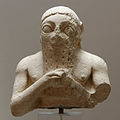 லுகல்-கிசால், உரூக் மன்னர்
 -
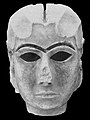 வர்காவின் முகமூடி
 -
![செம்தேத் நசிர் காலத்திய]] உரூக் நகர காளையின் சிற்பம், கிமு 3000](//upload.wikimedia.org/wikipedia/commons/thumb/5/57/Bull_Warka_Louvre_AO8218.jpg/120px-Bull_Warka_Louvre_AO8218.jpg) செம்தேத் நசிர் காலத்திய]] உரூக் நகர காளையின் சிற்பம், கிமு 3000
செம்தேத் நசிர் காலத்திய]] உரூக் நகர காளையின் சிற்பம், கிமு 3000 -
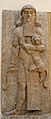 உரூக் நகர மன்னர் கில்கமெஷ் இடது கையில் சிங்கத்தையும், வலது கையில் பாம்பையும் ஏந்தியிருக்கும் சிற்பம்.
 -
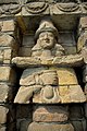
 இஷ்தர் கோயிலில் ஆண் தெய்வம், கிமு 1500, பெர்கமோன் அருங்காட்சியகம்
 -


![செம்தேத் நசிர் காலத்திய]] உரூக் நகர காளையின் சிற்பம், கிமு 3000](/wiki/%E0%AE%AA%E0%AE%9F%E0%AE%BF%E0%AE%AE%E0%AE%AE%E0%AF%8D:Bull_Warka_Louvre_AO8218.jpg)


இதனையும் காண்க[தொகு]
- ஹலாப் பண்பாடு
- உபைதுகள் காலம்
- உரூக் காலம்
- செம்தேத் நசிர் காலம்
- ஹலாப் பண்பாடு
- அசுன்னா பண்பாடு
- சமார்ரா பண்பாடு
- யாஸ் பண்பாடு
- மெசபடோமியா
- கில்கமெஷ்
- கில்கமெஷ் காப்பியம்
- பண்டைய அண்மை கிழக்கின் நகரங்கள்
அடிக்குறிப்புகள்[தொகு]
- ↑ Erech, ANCIENT CITY, IRAQ
- ↑ 2.0 2.1 Harmansah, 2007
- ↑ William Kennett Loftus (1857). Travels and researches in Chaldaea and Susiana: with an account of excavations at Warka, the "Erech" of Nimrod, and Shush, "Shushan the Palace" of Esther, in 1849-52. Robert Carter & Brothers. https://books.google.com/books?id=4ZiBAAAAIAAJ. "Of the primeval cities founded by Nimrod, the son of Gush, four are represented, in Genesis x. 10, as giving origin to the rest : — 'And the beginning of his kingdom was Babel, and Erech, and Accad, and Galneh, in the land of Shinar.' ...let us see if there be any site which will correspond with the biblical Erech — the second city of Nimrod. About 120 miles southeast of Babylon, are some enormous piles of mounds, which, from their name and importance, appear at once to justify their claim to consideration. The name of Warka is derivable from Erech without unnecessary contortion. The original Hebrew word 'Erk,' or 'Ark,' is transformed into 'Warka,' either by changing the aleph into vau, or by simply prefixing the vau for the sake of euphony, as is customary in the conversion of Hebrew names to Arabic. If any dependence can be placed upon the derivation of modern from ancient names, this is more worthy of credence than most others of like nature.... Sir Henry Rawlinson states his belief that Warka is Erech, and in this he is supported by concurrent testimony.... [Footnote: See page xvi. of the Twenty-ninth Annual Report of the Royal Asiatic Society, 1852 ; and Proceedings of the Royal Geogr. Society, vol. i., page 47]"
- ↑ While earlier scholars such as Jerome (4th century) had identified Erech with the Syrian city of Edessa (now within Turkey), the modern consensus is that it refers to the Sumerian city-state of Uruk in south Mesopotamia. See Warwick Ball, 2001, Rome in the East: the transformation of an empire, p. 89. Ball further speculates that the earlier traditions connecting Edessa (Orhai) with Erech might have arisen because the ancient Uruk was possibly 'transferred' to the more northerly location in the reign of Nabonidus of Babylon, 6th century BC.
மேற்கோள்கள்[தொகு]
- Baker, H.D.. The Urban Landscape in First Millennium BC Babylonia. University of Vienna.
- Paul-Alain Beaulieu (2003). The Pantheon of Uruk During the Neo-Babylonian Period. BRILL. பக். 424. பன்னாட்டுத் தரப்புத்தக எண்:90-04-13024-1. https://www.google.com/books?id=v-WRJhvfudIC.
- Charvát, Petr; Zainab Bahrani; Marc Van de Mieroop (2002). Mesopotamia Before History. London: Routledge. பக். 281. பன்னாட்டுத் தரப்புத்தக எண்:0-415-25104-4. https://books.google.com/?id=Ni6hWHO5HpIC.
- Crawford, Harriet E. W. (2004). Sumer and the Sumerians. Cambridge University Press. பக். 252. பன்னாட்டுத் தரப்புத்தக எண்:0-521-53338-4. https://books.google.com/?id=eX8y3yW04n4C.
- Fassbinder, J.W.E., and H. Becker, Magnetometry at Uruk (Iraq): The city of King Gilgamesh, Archaeologia Polona, vol. 41, pp. 122–124, 2003
- Harmansah, Ömür (2007-12-03). "The Archaeology of Mesopotamia: Ceremonial centers, urbanization and state formation in Southern Mesopotamia". Archived from the original on 2007-01-06. பார்க்கப்பட்ட நாள் 2011-08-28.
- Oppenheim, A. Leo; Erica Reiner (1977). Ancient Mesopotamia: Portrait of a Dead Civilization. Chicago: University of Chicago Press. பக். 445. பன்னாட்டுத் தரப்புத்தக எண்:0-226-63187-7. https://books.google.com/?id=u4pOhLAajE0C&dq=Ancient+Mesopotamia:+Portrait+of+a+Dead+Civilization.
மேலும் படிக்க[தொகு]
 "Erech". பிரித்தானிக்கா கலைக்களஞ்சியம் (11th) 9. (1911). Cambridge University Press. 734-735.
 - Green, MW (1984). "The Uruk Lament". Journal of the American Oriental Society 104 (2): 253–279. doi:10.2307/602171.
- Kuhrt, Amélie (1995). The Ancient Near East. London: Routledge. பக். 782. பன்னாட்டுத் தரப்புத்தக எண்:0-415-16763-9. https://books.google.com/?id=EGu_p23NaS8C.
- Liverani, Mario; Zainab Bahrani; Marc Van de Mieroop (2006). Uruk: The First City. London: Equinox Publishing. பக். 97. பன்னாட்டுத் தரப்புத்தக எண்:1-84553-191-4. https://books.google.com/?id=84FtQgAACAAJ.
- Lloyd, Seton (1955). Foundations in the Dust. New York, New York: Penguin Books. பக். 217. பன்னாட்டுத் தரப்புத்தக எண்:0-500-05038-4. https://books.google.com/?id=PW12jpEYPuEC&q=Foundations+in+the+Dust&dq=Foundations+in+the+Dust.
- Postgate, J.N. (1994). Early Mesopotamia, Society and Economy at the Dawn of History. New York, New York: Routledge Publishing. பக். 367. பன்னாட்டுத் தரப்புத்தக எண்:0-415-00843-3. https://books.google.com/?id=u50OAAAAQAAJ.
- Rothman, Mitchell S. (2001). Uruk, Mesopotamia & Its Neighbors. Santa Fe: School of American Research Press. பக். 556. பன்னாட்டுத் தரப்புத்தக எண்:1-930618-03-4. https://books.google.com/?id=vqtQlBH2wB4C&dq=Uruk,+Mesopotamia+%26+Its+Neighbors.
- Krystyna Szarzyńska, Observations on the Temple Precinct EŠ3 in Archaic Uruk, Journal of Cuneiform Studies, vol. 63, pp. 1–4, 2011
- Vos, Howard F. (1977). Archaeology in Bible Lands. Chicago, Illinois: Moody Press. பக். 399. பன்னாட்டுத் தரப்புத்தக எண்:978-0-8024-0293-6. https://archive.org/details/archaeologyinbib0000vosh_j0b7.
- Eva Strommenger, The Chronological Division of the Archaic Levels of Uruk-Eanna VI to III/II: Past and Present, American Journal of Archaeology, vol. 84, no. 4 , pp. 479–487, (Oct., 1980)
வெளி இணைப்புகள்[தொகு]
- Earliest evidence for large scale organized warfare in the Mesopotamian world (Hamoukar vs. Uruk?)
- Uruk at CDLI wiki
- Archaeological Expedition Mapping Ancient City Of Uruk in 2002
- Digital images of tablets from Uruk - CDLI
