சிந்து ஆறு
| சிந்து (دریائے سندھ) | |
| River
சிந்து ஆறு | |
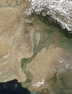
செய்மதியில் இருந்து படம்பிடிக்கப்பட்ட இந்தியா பாக்கித்தானில் உள்ள சிந்து ஆற்றின் வடி நிலம்.
| |
| நாடுகள் | |
|---|---|
| மாநிலம் | வடக்கு நிலங்கள், சம்மு காசுமீர் வடமேற்கு எல்லைப்புற மாகாணம், பஞ்சாப் சிந்து திபெத் |
| கிளையாறுகள் | |
| - இடம் | ஜான்ஸ்கர் ஆறு, சுரு ஆறு, சோன் ஆறு, ஜீலம் ஆறு, செனாப் ஆறு, ராவி ஆறு, பியாஸ் ஆறு, சத்லஜ் ஆறு, பஞ்ச்நாத் ஆறு |
| - வலம் | ஷியோக் ஆறு, ஹன்சா ஆறு, கில்ஜித் ஆறு, ஸ்வாட் ஆறு, குனார் ஆறு, காபூல் ஆறு, குருரம் ஆறு, கோமல் ஆறு, ஜொவ் ஆறு |
| நகரங்கள் | லே, ஸ்கார்டு, டாசு, பீஷம், தாகோட், தேரா இஸ்மாயில் கான், சுக்குர், ஐதராபாத் |
| Primary source | செங்ஜி ஸாங்க்போ |
| - அமைவிடம் | திபெத் பீடபூமி |
| Secondary source | கர் சாங்போ |
| Source confluence | |
| - location | ஷிங்குவாங்ஹி, நேரி ப்ரிபெக்சர், சீனா |
| - உயர்வு | 4,255 மீ (13,960 அடி) |
| கழிமுகம் | அரபிக் கடல் (முதன்மை), கட்ச் பாலைவனம் (இரண்டாம்) |
| - அமைவிடம் | சிந்து ஆற்று வடிநிலம் (முதன்மை), தார்ப் பாலைவனம் (இரண்டாம்), பாக்கித்தான் |
| - elevation | 0 மீ (0 அடி) |
| நீளம் | 3,610 கிமீ (Expression error: Unrecognized punctuation character ",". மைல்) |
| வடிநிலம் | 11,65,000 கிமீ² (4,49,809 ச.மைல்) |
| Discharge | for அரபிக்கடல் |
| - சராசரி | |
| - மிகக் கூடிய | |
| - மிகக் குறைந்த | |

சிந்து ஆறு (உருது: دریائے سندھ; இந்தி:सिंधु; எளிய சீனம்: 印度河) என்பது தெற்காசியாவில் தெற்கே பாய்ந்து செல்லும் ஒரு பெரிய ஆறு, இது சிந்து அல்லது அபாசியின் என்றும் அழைக்கப்படுகிறது. பாரதியின் சிந்து நதி மீதினிலே என்ற பாடலால் சிந்து நதி என்று பரவலாக அறியப்படுகிறது. இந்த ஆற்றின் மொத்த நீளம் 3,610 கிமீ (1,988 மைல்) ஆகும், இது ஆசியாவின் நீண்ட ஆறுகளில் ஒன்றாகவும், பாகிஸ்தானில் பாயும் முக்கியமான ஆறாகவும் உள்ளது. இவ்வாறு இமய மலைத் தொடரில் கயிலை மலையில் மானசரோவர் அருகே திபெத்தின் மேற்குப் பகுதியில் தோன்றும் இந்த ஆறு, லடாக் வழியாக பாய்ந்து, காஷ்மீர், மற்றும் பாகிஸ்தானின் வடக்கு நிலங்கள், வடமேற்கு எல்லைப்புற மாகாணம் வழியாகவும் பின் பஞ்சாப்பில் பாய்ந்து சென்று இறுதியில் சிந்து பகுதியின் தட்டா நகரத்திற்கு அருகில் அரபிக் கடலில் கலக்கிறது. இது பாக்கிஸ்தானின் மிக நீண்ட ஆறு மற்றும் தேசிய நதி ஆகும்.
இந்த ஆற்றின் மொத்த நீர் வடிகால் பகுதி 1,165,000 km2 (450,000 sq mi) ஆகும். இதன் மதிப்பிடப்பட்ட வருடாந்தர வெள்ள ஓட்டம் சுமார் 243 km3 (58 cu mi), இது நைல் நதியின் ஆண்டு வெள்ளத்தில் இருமடங்காகவும், டைகிரிஸ் மற்றும் யூபிரிடிஸ் ஆறுகள் ஆகியவற்றின் நீரில் மூன்று பங்கு கூடுதலாகவும் உள்ளது. இதில் ஆண்டுதோறும் பாயும் நீரின் அளவில் உலகில் இருபத்தோராவது பெரிய ஆறாக உள்ளது. ஜாதகர் என்பது லடாக்கில் அதன் இடது கிளை ஆறு ஆகும். சமவெளிப்பகுதிகளில், அதன் இடது கிளைதான் செனாப் ஆறு ஆகும், அவற்றில் நான்கு முக்கிய துணை நதிகள் உள்ளன அவை, ஜீலம், ரவி, பியாஸ், சட்லஜ் ஆகும். சிந்து ஆற்றின் வலது துணை ஆறுகளில் முதன்மையானவை ஷிக் ஆறு, கில்கிட் ஆறு, காபூல் ஆறு, கோமல் ஆறு, குராம் ஆறு ஆகியவை ஆகும். இமயமலையில் உள்ள பனிப்பாறைகள் மற்றும் ஆறுகள் கொண்ட மலையுச்சியிலிருந்து துவங்கி, இந்த ஆறு காடுகள், சமவெளிகள், வறண்ட கிராமப்புறங்களில் சூழல் மண்டலத்தை வளப்படுத்துகிறது.
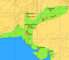
சப்த சிந்து என்று ரிக்வேதத்தில் குறிப்பிடப்பட்ட இன்றைய பாகிஸ்தானின் சிந்து வடிநிலத்தை சிந்து ஆறு உருவாக்குகிறது மற்றும் ஈரானின் செயிண்ட் அவெத்தா ஹிப்தா சிந்து (இரண்டு சொற்களின் பொருளும் "ஏழு ஆறுகள்") என அழைத்தது. சிந்து சமவெளி நாகரிகம் இவ்வாற்றுப் படுக்கையிலே தோன்றி வளர்ந்த பழம் பண்பாடு. சிந்து ஆற்றின் அமைவிடத்தை அடிப்படையாகக் கொண்டு இவ்வாற்றின் கிழக்குப் பகுதியின் பெருநிலத்தை இந்தியா என்றும், அப்பகுதி மக்களை இந்து என்றும் பண்டைய ஐரோப்பியர் அழைத்ததே இன்றைய இந்தியாவின் பெயர்க் காரணம் என்பது குறிப்பிடத்தக்கது. (இந்துகுஷ் மலையில் இருந்து வந்ததாகவும் கூறுவர்)
சொற்பிறப்பு மற்றும் பெயர்கள்[தொகு]
இந்த ஆறு பண்டைய ஈரானியர்களுக்கு அவெஸ்தாவில் குறிப்பிடப்பட்டுள்ளது, சமஸ்கிருதத்தில் சிந்து என்றும், அசிரியர்கள் (கி.மு.7 ஆம் நூற்றாண்டின் துவக்கத்தில்) சிந்தா என்றும், பாரசீகர்கள் அப்-இ-சிந்த் என்றும், கிரேக்கர்கள் இந்தோஸ் எனவும், ரோமானியர்கள் சிந்து என்றும், பஷ்தூன் அபாசிந்த் எனவும், அரேபியர்கள் அல்-சிந்து என்றும், சீனர்கள் சின்டோவை என்றும், ஜாவா மக்கள் சாத்ரி என்றும், பாளியில், சிந்து என்றால் "ஆறு, ஓடை" எனவும் குறிப்பாக சிந்து ஆற்றையும் குறிக்கிறது.[1]

சிந்து ஆற்றைக் குறிக்க ஆங்கிலத்தில் பயன்படுத்தும் சொல்லான இண்டஸ் (Indus) என்ற சொல் பண்டைய கிரேக்க ச்சொல்லான "Indós" (Ἰνδός) என்ற சொல்லின் உரோமானியமயமாக்களின் வடிவமாகும், இது பழைய பாரசீக வார்த்தையான "ஹிந்துஷ்" என்பதிலிருந்து கடன் பெறப்பட்டது, இது சமஸ்கிருத வார்த்தையான "சிந்து" விலிருந்து கடன் வாங்கப்பட்டது. மெகஸ்தினேசின் நூலான இண்டிகா என்ற பெயர், "Indós" (Ἰνδός) என்ற கிரேக்க சொல்லில் இருந்து வந்தது, மேலும் இதில் அலெக்சாந்தரின் படைகள் பெருவெள்ளம் கொண்ட இந்த ஆற்றை எவ்வாறு கடந்து சென்றது என்பது குறித்த சமகால வரலாற்றை விவரிக்கிறது. பண்டைய கிரேக்கர்கள் இந்தியர்களை (இன்றைய வடமேற்கு இந்தியா மற்றும் பாக்கிஸ்தான் மக்கள்) "Indói" (Ἰνδοί), என குறிப்பிட்டனர் இதற்கு "சிந்து மக்கள்" என்று பொருள். [2] இந்தியா மற்றும் பாக்கிஸ்தானின் சிந்து மாகாணமும் தங்கள் பெயரை இந்த ஆற்றின் பெயரிலிருந்தே பெற்றன. [3]
ரிக்வேதமும் சிந்துவும்[தொகு]
ரிக்வேதம் பல புராண ஆறுகளை விவரிக்கிறது, அதில் ஒன்று "சிந்து". ரிக்வேதத்தில் குறிப்பிப்பட்டுள்ள "சிந்து" என்பது இன்றைய சிந்து ஆறு என்று கருதப்படுகிறது, மேலும் அந்த நூலில் 176 முறை குறிப்பிடப்பட்டுள்ளது-பன்மையில் 95 முறை பன்மடங்கான அர்த்தத்தில் பயன்படுத்தப்படுகிறது. ரிக்வேதத்தில், குறிப்பிடத்தக்க பாடல்களில், நாடிஸ்டு சுக்மாவின் பாடலில் உள்ள ஆறுகளின் பட்டியலில், சிந்து ஆறு குறிப்பிடப்படுகிறது. ரிக்வேத பாடல்களில் குறிப்பிடப்பட்ட அனைத்து நதிகளுக்கும் பெண் பாலில் குறிப்பிடப்பட்டுள்ளது, ஆனால் "சிந்து" ஆற்றை ஆண்பாலாக குறிக்கிறது. சிந்து ஆறு ஒரு வலுவான வீரனாக கருதப்பட்டு மற்ற ஆறுகள் தேவதைகளாக பார்க்கப்பட்டும் பால், வெண்ணெய் ஆகியவற்றை விளைவிக்கும் பசுக்களுடன் ஒப்பிடப்பட்டுள்ளது.
பிற பெயர்கள்[தொகு]
இப்பகுதியில் உள்ள பிற மொழிகளில் இந்த ஆறானது, सिन्धु नद (சிந்த் நதி) என இந்தி மற்றும் நேபாளி மொழிகளிலும், سنڌو (சிந்து) சிந்தி மொழியிலும், سندھ (சிந்து) சாமுகி பஞ்சாபி, ਸਿੰਧ ਨਦੀ (சிந்த் நதி) குர்முகி பஞ்சாபி, اباسين (அபசின் லிட்டர் "ஆறுகளின் தந்தை") பஷ்தூ மொழியில், نهر السند (நஹார் அல்-சிந்து) அரபு மொழியில், སེང་གེ་གཙང་པོ། (சீங் ஜி கிட்சங் போ லிட். இதன் பொருள் "சிங்க ஆறு") திபெத்திய மொழி, 印度 (யிங்டு) சீன மொழியில், நிலாப் (Nilab) துருக்கிய மொழியில் என பல்வேறு மொழிகளில் அழைக்கப்படுகிறது.
விளக்கம்[தொகு]

சிந்து ஆறு பாக்கிஸ்தானின் பொருளாதாரத்துக்கு முதன்மையான நீர் ஆதாரங்களை வழங்குகிறது - குறிப்பாக நாட்டின் உணவுக் களஞ்சியமான பஞ்சாப் மாகாணத்தின் பெரும்பாலான விவசாய உற்பத்தியானது சிந்து ஆற்றை நம்பியுள்ளது. பஞ்சாப் என்ற சொல்லின் பொருள் "ஐந்து ஆறுகள் நிலம்" என்பதாகும், அந்த ஐந்து ஆறுகள் ஜீலம், செனாப், ராவி, பியாஸ், சத்லஜ் என்றும் அழைக்கப்படுகின்றன, இவை அனைத்தும் சிந்துவுடன் சேறுகின்றன. சிந்து ஆறானது பல கனரக தொழிற்சாலைகளுக்கு உதவியாக உள்ளது மற்றும் பாக்கிஸ்தானின் முதன்மை குடிநீர் ஆதாரமாகவும் உள்ளது.
சிந்துவின் முதன்மையான நீர் ஆதாரம் திபெத்தில் உள்ளது; திபெத்தில் தோன்றிய சிந்து ஆறு, பின்னர் லடாக் மற்றும் பால்டிஸ்த் வழியாக வடமேற்குப் பகுதியில் காரகோரம் மலைக்கு தெற்கே கில்கித் நோக்கி செல்கிறது. ஷியோக், ஷிகார், கில்கிட் ஆகிய ஆறுகள் ஆறுகள் பனி ஆறுகளோடு முதன்மை ஆற்றில் வந்து சேர்கின்றன. பின்னர் இது பெஷாவர் மற்றும் ராவல்பிண்டிக்கு இடையே உள்ள மலைகளில் இருந்து தெற்கே வளைந்து செல்கிறது. நங்க பர்வதத்துக்கு அருகே ஆழமான பள்ளத்தாக்குகளை சிந்து ஆறு 4,500-5,200 மீட்டர் (15,000-17,000 அடி) ஆழத்தில் கடந்து செல்கிறது. இது ஹசாரா முழுவதும் விரைவாக ஓடுகிறது, மற்றும் டார்பெலா அணையால் இதன் நீர் கட்டுப்படுத்தப்படுகிறது. காபுல் ஆறு அட்டாக் அருகே இதனுடன் இணைகிறது. கடலுக்கு செல்லும் மீதமுள்ள பாதையில் எஞ்சியுள்ள பஞ்சாப் மற்றும் சிந்து பகுதிகளில், நதியின் ஓட்டம் மெதுவாகவும், பல கால்வாய்களாக பிரிந்ததாகவும் இருக்கும். இது மித்தன்கோட் பகுதியில் பஞ்ச்நாத் ஆறு இணைகிறது. இச்சங்கமத்துக்கு அப்பால், இந்த ஆறு காபூல் நதி, சிந்து நதி, பஞ்சாப் ஆறுகள் ஆகியவற்றின் நீரை எடுத்துச் செல்வதால், சத்நாத் நதி (சாத்தி = "ஏழு", நடி = "நதி") என்ற பெரைப் பெறுகிறது. ஜாம்ஷோராவாலைக் கடந்து, இது தட்டாவுக்கு அருகில் கடலில் சேர்கிறது.
உலகின் சில நதிகளில் மட்டுமே காணப்படும் ஒன்றான கழிமுக அலைஏற்றம் சிந்து ஆற்றில் காணப்படுகிறது. இதன் நீராதாரமானது திபெத், இந்திய ஆளுகைக்கு உட்பட்ட ஜம்மு காஷ்மீர் மற்றும் இமாச்சல பிரதேசம் மற்றும் பாக்கிஸ்தானின் வடக்கு நிலங்கள் ஆகியபகுதிகளிலும், இமயமலை காரகோரம், இந்து குஷ் ஆகிய மலைகளில் உள்ள பனிக்கட்டி மற்றும் பனிப்பாறைகளால் இருந்து கிடைக்கிறது. ஆற்றின் நீர்பெருக்கானது பருவ காலத்துக்கு ஏற்ப மாறுபடுகிறது - குளிர்காலத்தில் நீர் பெரிதும் குறைந்து காணப்படும், சூலை முதல் செப்டம்பர் வரையிலான பருவ மழைக்காலத்தில் வெள்ளம் மிகுந்து காணப்படும். வரலாற்றுக்கு முந்தைய காலங்களில் இருந்து ஆற்றின் போக்கில் நிலையான மாற்றங்கள் ஏற்பட்டதற்கான சான்றுகள் உள்ளன - கட்ச் பாலைவனம் மற்றும் பன்னி புல்வெளிகளுக்கு அருகில் இருந்து மேற்கு நோக்கி திசைதிரும்பியது.[4][5]
இதனையும் காண்க[தொகு]
மேற்கோள்கள்[தொகு]
- ↑ G.P. Malalasekera 2003, ப. 1137.
- ↑ Kuiper 2010, ப. 86.
- ↑ Encyclopædia Britannica.
- ↑ 70% of cattle-breeders desert Banni; by Narandas Thacker, TNN, 14 February 2002; The Times of India
- ↑ "564 Charul Bharwada & Vinay Mahajan, Lost and forgotten: grasslands and pastoralists of Gujarat".
வெளி இணைப்புகள்[தொகு]
- Blankonthemap The Northern Kashmir Website
- Bibliography on Water Resources and International Law Peace Palace Library
- Northern Areas Development Gateway
- The Mountain Areas Conservancy Project
- Indus River watershed map (World Resources Institute) பரணிடப்பட்டது 2005-04-13 at the வந்தவழி இயந்திரம்
- Indus Treaty பரணிடப்பட்டது 2005-12-20 at the வந்தவழி இயந்திரம்
- Baglihar Dam issue பரணிடப்பட்டது 2005-06-17 at the வந்தவழி இயந்திரம்
- Indus
- Indus Wildlife at the வந்தவழி இயந்திரம் (பரணிடப்பட்டது 7 அக்டோபர் 2006)
- First raft and kayak descents of the Indus headwaters in Tibet பரணிடப்பட்டது 2015-05-25 at the வந்தவழி இயந்திரம்
- Pulitzer Center on Crisis Reporting's project on water issues in South Asia பரணிடப்பட்டது 2009-07-23 at the வந்தவழி இயந்திரம்


