
படிமம்:India-states-numbered.svg

மூலக்கோப்பு (SVG கோப்பு, பெயரளவில் 1,594 × 1,868 பிக்சல்கள், கோப்பு அளவு: 306 KB)
| இது விக்கிமீடியா பொதுக்கோப்பகத்தில் இருக்கும் ஒரு கோப்பாகும். இக்கோப்பைக் குறித்து அங்கே காணப்படும் படிம விளக்கப் பக்கத்தை இங்கே கீழே காணலாம்.
|
சுருக்கம்
| விளக்கம் |
English: States of India, numbered.
Norsk nynorsk: Indiske statar og territorium |
| நாள் | See file history below. |
| மூலம் | Based on Planemad's w:Image:India map en.svg |
| ஆசிரியர் | See file history below. |
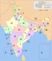
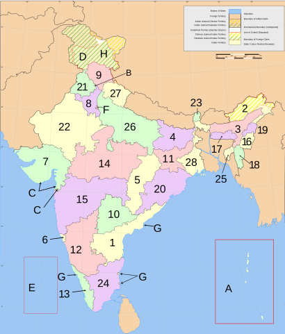
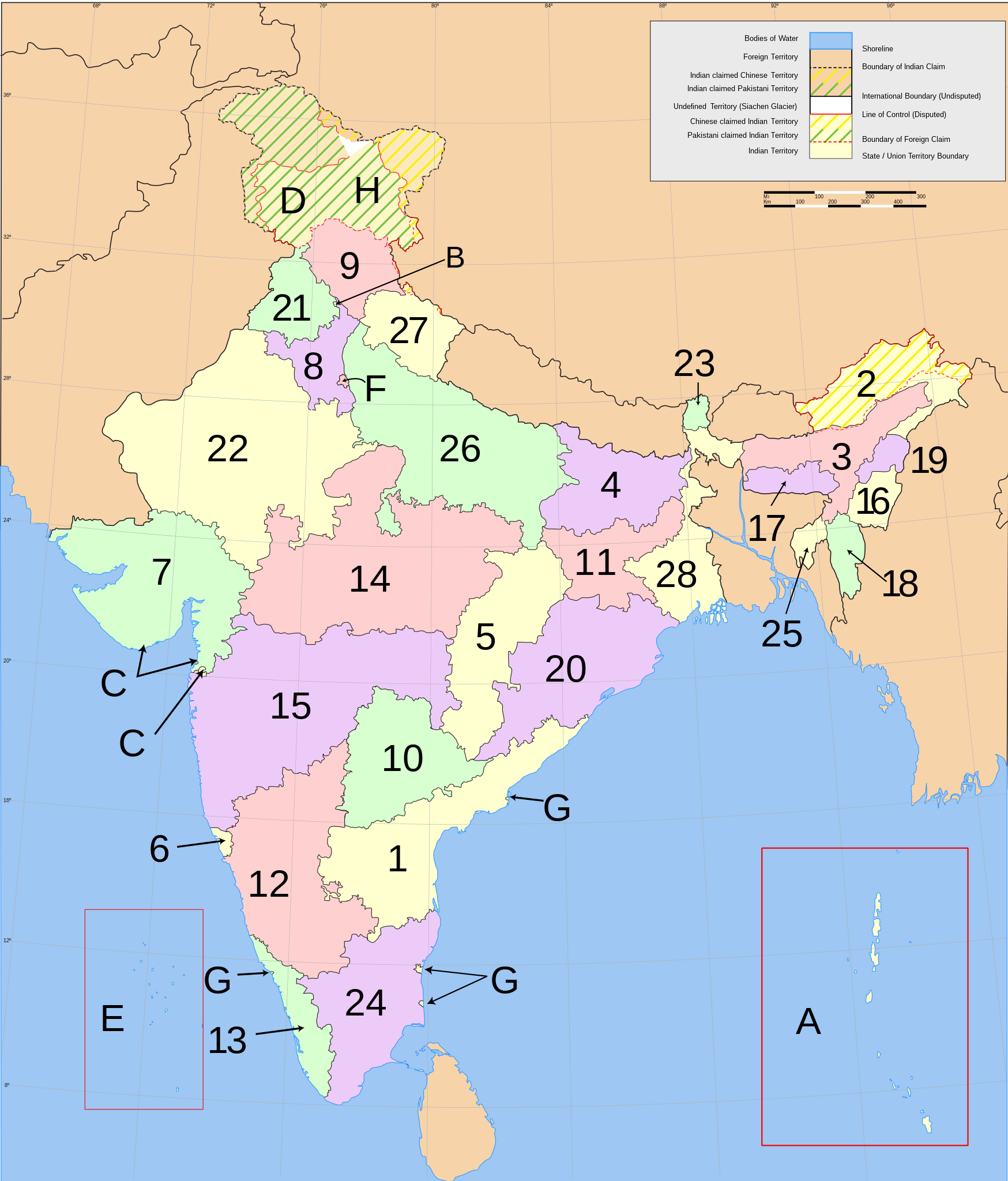
English: Main administrative divisions of india
India consists of 28 states and eight union territories. All states, and the three union territories of Jammu and Kashmir, Puducherry and Delhi, have elected legislatures and governments patterned on the Westminster model. The other five union territories are directly ruled by the Central government through appointed administrators. In 1956, under the States Reorganisation Act, states were formed on a linguistic basis.[1] Since then, this structure has remained largely unchanged.
Each state or union territory is further divided into administrative districts.[2] The districts in turn are further divided into:
- in rural areas: (named tehsils / taluks / mandals / subdivisions / circles / communes depending of the state or territory), local councils (gram panchayats), and eventually into villages and wards (gram sabhas), or
- in large urban areas: metropoles (comparable to subdistricts but with more autonomy), municipalities (or municipal corporations), and eventually into civic zones and civic wards.
For interstate cooperation and planning, the 28 states and 8 union territories are also grouped into 6 zones.
- States
- Andhra Pradesh
- Arunachal Pradesh
- Assam
- Bihar
- Chhattisgarh
- Goa
- Gujarat
- Haryana
- Himachal Pradesh
- Telangana
- Jharkhand
- Karnataka
- Kerala
- Madhya Pradesh
- Maharashtra
- Manipur
- Meghalaya
- Mizoram
- Nagaland
- Orissa
- Punjab
- Rajasthan
- Sikkim
- Tamil Nadu
- Tripura
- Uttar Pradesh
- Uttarakhand
- West Bengal
- Union territories
Esperanto: Subŝtatoj kaj teritorioj de Barato
- Subŝtatoj
- Andra-Pradeŝo
- Arunaĉal-Pradeŝo
- Asamo
- Biharo
- Ĉatisgaro
- Goao
- Guĝarato
- Harjano
- Himaĉal-Pradeŝo
- Ĝamuo kaj Kaŝmiro
- Ĝarkhando
- Karnatako
- Keralao
- Madhja-Pradeŝo
- Maharaŝtro
- Manipuro
- Meghalajo
- Mizoramo
- Nagalando
- Oriso
- Panĝabo
- Raĝastano
- Sikimo
- Tamilnado
- Tripuro
- Utar-Pradeŝo
- Utarakando
- Okcidenta Bengalio
- Telangano
- Uniaj teritorioj
Norsk nynorsk: Indiske statar og territorium
- Statas
- Andhra Pradesh
- Arunachal Pradesh
- Assam
- Bihar
- Chhattisgarh
- Goa
- Gujarat
- Haryana
- Himachal Pradesh
- Jammu og Kashmir
- Jharkhand
- Karnataka
- Kerala
- Madhya Pradesh
- Maharashtra
- Manipur
- Meghalaya
- Mizoram
- Nagaland
- Orissa
- Punjab|
- Rajasthan
- Sikkim
- Tamil Nadu
- Tripura
- Uttar Pradesh
- Uttarakhand
- Vest-Bengal
- Telangana
- Unionsterritorium
References
- ↑ States Reorganisation Act, 1956. Constitution of India. Commonwealth Legal Information Institute. Archived from the original on 2008-05-16. Retrieved on 31 October 2007.; See also: Political integration of India.
- ↑ Districts of India. Government of India. National Informatics Centre (NIC). Retrieved on 25 November 2007.
அனுமதி

|
GNU Free Documentation License விதிமுறைகளின் கீழ் இந்த ஆவணத்தை நகலெடுக்க, விநியோகிக்க மற்றும்/அல்லது மாற்றுவதற்கு அனுமதி வழங்கப்பட்டுள்ளது, Free Software Foundation;ஆல் வெளியிடப்பட்ட பதிப்பு 1.2 அல்லது அதற்குப் பிந்தைய பதிப்பு, மாற்றமில்லாத பிரிவுகள், முன் அட்டை உரைகள் மற்றும் பின் அட்டை உரைகள் இல்லாமல் வெளியிடப்பட்டது. GNU Free Documentation License என்ற தலைப்பில் உரிமத்தின் நகல் சேர்க்கப்பட்டுள்ளது. |
| இந்த கோப்பு Creative Commons Attribution-Share Alike 3.0 Unported உரிமத்தின் கீழ் உள்ளது. | ||
| ||
| This licensing tag was added to this file as part of the GFDL licensing update. |
- நீங்கள் சுதந்திரமாக:
- பகிர்ந்து கொள்ள – வேலையை நகலெடுக்க, விநியோகிக்க மற்றும் அனுப்ப
- மீண்டும் கலக்க – வேலைக்கு பழகிக்கொள்ள.
- கீழ்க்காணும் விதிகளுக்கு ஏற்ப,
- பண்புக்கூறுகள் – நீங்கள் பொருத்தமான உரிமையை வழங்க வேண்டும், உரிமத்திற்கான இணைப்பை வழங்க வேண்டும் மற்றும் மாற்றங்கள் செய்யப்பட்டிருந்தால் குறிப்பிட வேண்டும். நீங்கள் ஏற்புடைய எந்த முறையிலும் அவ்வாறு செய்யலாம், ஆனால் எந்த வகையிலும் உரிமதாரர் உங்களை அல்லது உங்கள் பயன்பாட்டிற்கு ஒப்புதல் அளிக்கும் படி பரிந்துரைக்க கூடாது.
கோப்பின் வரலாறு
குறித்த நேரத்தில் இருந்த படிமத்தைப் பார்க்க அந்நேரத்தின் மீது சொடுக்கவும்.
| நாள்/நேரம் | நகம் அளவு சிறுபடம் | அளவுகள் | பயனர் | கருத்து | |
|---|---|---|---|---|---|
| தற்போதைய | 18:08, 10 சனவரி 2021 | | 1,594 × 1,868 (306 KB) | Sbb1413 | Updated further. |
| 12:24, 25 சனவரி 2016 |  | 1,594 × 1,868 (309 KB) | Csyogi | Telangana State update | |
| 04:35, 3 திசம்பர் 2011 |  | 1,594 × 1,868 (297 KB) | Kmusser | Re-size Goa label | |
| 18:38, 24 நவம்பர் 2011 |  | 1,594 × 1,868 (276 KB) | Fred the Oyster | Tidy up, use Arial font as more 'universal' | |
| 15:34, 5 அக்டோபர் 2011 |  | 1,594 × 1,868 (298 KB) | Citypeek | changed font from Sans to DejaVu Sans. | |
| 07:51, 5 மார்ச்சு 2007 |  | 1,594 × 1,868 (304 KB) | Nichalp | Swapping Pondicherry NCT | |
| 05:59, 4 மார்ச்சு 2007 |  | 1,594 × 1,868 (304 KB) | Nichalp | Correction in the numbering scheme according to MoS | |
| 15:58, 15 பெப்பிரவரி 2007 |  | 1,594 × 1,868 (304 KB) | Nichalp | Reverted to earlier revision | |
| 00:39, 12 பெப்பிரவரி 2007 |  | 1,594 × 1,868 (304 KB) | Abecedare | Reverted to earlier revision | |
| 06:07, 25 நவம்பர் 2006 |  | 1,594 × 1,868 (304 KB) | Nichalp | Reverted to earlier revision |
கோப்பு பயன்பாடு
பின்வரும் 5 பக்கங்கள் இணைப்பு இப் படிமத்துக்கு இணைக்கபட்டுள்ளது(ளன):
கோப்பின் முழுமையான பயன்பாடு
கீழ்கண்ட மற்ற விக்கிகள் இந்த கோப்பை பயன்படுத்துகின்றன:
- ang.wikipedia.org-திட்டத்தில் இதன் பயன்பாடு
- an.wikipedia.org-திட்டத்தில் இதன் பயன்பாடு
- ast.wikipedia.org-திட்டத்தில் இதன் பயன்பாடு
- as.wikipedia.org-திட்டத்தில் இதன் பயன்பாடு
- ban.wikipedia.org-திட்டத்தில் இதன் பயன்பாடு
- be-tarask.wikipedia.org-திட்டத்தில் இதன் பயன்பாடு
- be.wikipedia.org-திட்டத்தில் இதன் பயன்பாடு
- bg.wikipedia.org-திட்டத்தில் இதன் பயன்பாடு
- bh.wikipedia.org-திட்டத்தில் இதன் பயன்பாடு
- blk.wikipedia.org-திட்டத்தில் இதன் பயன்பாடு
- bn.wikipedia.org-திட்டத்தில் இதன் பயன்பாடு
- bpy.wikipedia.org-திட்டத்தில் இதன் பயன்பாடு
- br.wikipedia.org-திட்டத்தில் இதன் பயன்பாடு
- bs.wikipedia.org-திட்டத்தில் இதன் பயன்பாடு
- ca.wikipedia.org-திட்டத்தில் இதன் பயன்பாடு
- da.wikipedia.org-திட்டத்தில் இதன் பயன்பாடு
- diq.wikipedia.org-திட்டத்தில் இதன் பயன்பாடு
- dv.wikipedia.org-திட்டத்தில் இதன் பயன்பாடு
- el.wikipedia.org-திட்டத்தில் இதன் பயன்பாடு
- en.wikipedia.org-திட்டத்தில் இதன் பயன்பாடு
- File talk:India-locator-map-blank.svg
- User:Jonny-mt/Gallery of current first-level administrative country subdivisions maps
- Template talk:Christianity in India sidebar
- Talk:Serbia/Archive 4
- File:India-states.svg
- File:Indiastates.jpg
- Talk:India/Archive 28
- Wikipedia:Graphics Lab/Map workshop/Archive/Dec 2011
- Talk:China/Archive 15
- User:Gufranazmi
- User:Ibsind
- Wikipedia:Graphics Lab/Map workshop/Archive/Mar 2018
- en.wiktionary.org-திட்டத்தில் இதன் பயன்பாடு
- es.wikipedia.org-திட்டத்தில் இதன் பயன்பாடு
சிறப்பு பக்கம்-மொத்த பயன்பாடு - இதன் மூலம் இந்த கோப்பின் மொத்த பயன்பாட்டை அறிய முடியும்