
படிமம்:Sub-Saharan Africa definition UN.png
இதைவிட அளவில் பெரிய படிமம் இல்லை.
Sub-Saharan_Africa_definition_UN.png (362 × 340 படவணுக்கள், கோப்பின் அளவு: 6 KB, MIME வகை: image/png)
| இது விக்கிமீடியா பொதுக்கோப்பகத்தில் இருக்கும் ஒரு கோப்பாகும். இக்கோப்பைக் குறித்து அங்கே காணப்படும் படிம விளக்கப் பக்கத்தை இங்கே கீழே காணலாம்.
|

|
This map image could be re-created using vector graphics as an SVG file. This has several advantages; see Commons:Media for cleanup for more information. If an SVG form of this image is available, please upload it and afterwards replace this template with
{{vector version available|new image name}}.
It is recommended to name the SVG file “Sub-Saharan Africa definition UN.svg”—then the template Vector version available (or Vva) does not need the new image name parameter. |
| விளக்கம் |
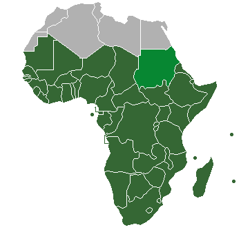
Definition of "Sub-Saharan Africa" as used in the statistics of many the UN institutions. Sudan is also classified as North Africa by the United Nations. |
| நாள் | (UTC) |
| மூலம் | |
| ஆசிரியர் |
| இது ஒரு திருத்தப்பட்ட படிமமாகும், அதாவது இதன் மூல வடிவத்திலிருந்து கணினி மூலம் இதில் மாற்றங்கள் செய்யப்பட்டுள்ளது. திருத்தங்கள்: binary colouring of countries. மூலக்கோப்பை இங்கு காணலாம்: HDImap spectrum2006 Africa.png. திருத்தங்களைச் செய்தவர் Jcherlet.
|
இந்த ஆக்கத்தின் காப்புரிமையாளரான நான் இதனைப் பின்வரும் உரிமத்தின் கீழ் வெளியிடுகின்றேன்:
| I, the copyright holder of this work, release this work into the public domain. This applies worldwide. சில நாடுகளில் இது சாத்தியமில்லாது போகலாம். அவ்வாறாயின் : I grant anyone the right to use this work for any purpose, without any conditions, unless such conditions are required by law. |
Original upload log
This image is a derivative work of the following images:
- File:HDImap_spectrum2006_Africa.png licensed with PD-self
- 2007-03-09T10:43:40Z Dbachmann 356x344 (7521 Bytes) == Summary == Detail of [[:Image:HDImap spectrum2006.png]]. [[:en:United Natiows|UN]] [[:en:Human Development Index|Human Development Index (HDI)]] for 2004, derived from 2006 UN HDI report. An HDI below 0.5 is considered to
Uploaded with derivativeFX
கோப்பின் வரலாறு
குறித்த நேரத்தில் இருந்த படிமத்தைப் பார்க்க அந்நேரத்தின் மீது சொடுக்கவும்.
| நாள்/நேரம் | நகம் அளவு சிறுபடம் | அளவுகள் | பயனர் | கருத்து | |
|---|---|---|---|---|---|
| தற்போதைய | 20:47, 19 சூலை 2013 | | 362 × 340 (6 KB) | Maproom | Reshaded South Sudan, which the UN now regards as in East Africa, not North Africa: see http://unstats.un.org/unsd/methods/m49/m49regin.htm |
| 13:27, 12 ஏப்பிரல் 2012 |  | 362 × 340 (9 KB) | Hazhk | Adding different shading for Sudan & S. Sudan because they're also classified as being part of North Africa by the UN | |
| 22:02, 9 சூலை 2011 |  | 356 × 344 (11 KB) | Maphobbyist | South Sudan has become independent on July 9, 2011. Sudan and South Sudan are shown with the new international border between them. | |
| 06:46, 31 மார்ச்சு 2011 |  | 356 × 344 (10 KB) | Hoshie | added Cabinda (Angola) to map | |
| 11:18, 15 திசம்பர் 2010 |  | 356 × 344 (6 KB) | Jcherlet | {{Information |Description=Definition of Sub-Saharan Africa, according to the United Nations institutions |Source=*File:HDImap_spectrum2006_Africa.png |Date=2010-12-15 11:13 (UTC) |Author=*Jcherlet: '''Jcherlet''' *derivative work: |
கோப்பு பயன்பாடு
பின்வரும் 2 பக்கங்கள் இணைப்பு இப் படிமத்துக்கு இணைக்கபட்டுள்ளது(ளன):
கோப்பின் முழுமையான பயன்பாடு
கீழ்கண்ட மற்ற விக்கிகள் இந்த கோப்பை பயன்படுத்துகின்றன:
- ast.wikipedia.org-திட்டத்தில் இதன் பயன்பாடு
- ca.wikipedia.org-திட்டத்தில் இதன் பயன்பாடு
- ckb.wikipedia.org-திட்டத்தில் இதன் பயன்பாடு
- cs.wikipedia.org-திட்டத்தில் இதன் பயன்பாடு
- de.wikipedia.org-திட்டத்தில் இதன் பயன்பாடு
- en.wikipedia.org-திட்டத்தில் இதன் பயன்பாடு
- Sub-Saharan Africa
- Water supply and sanitation in sub-Saharan Africa
- Wikipedia:Reference desk/Archives/Humanities/2013 October 5
- Category:Birds of Sub-Saharan Africa
- Category:Fauna of Sub-Saharan Africa
- Category:Biota of Sub-Saharan Africa
- Category:Mammals of Sub-Saharan Africa
- User:DexDor/Categorization of organisms by geography
- Category:Moths of Sub-Saharan Africa
- Category:Amphibians of Sub-Saharan Africa
- et.wikipedia.org-திட்டத்தில் இதன் பயன்பாடு
- ha.wikipedia.org-திட்டத்தில் இதன் பயன்பாடு
- he.wikipedia.org-திட்டத்தில் இதன் பயன்பாடு
- id.wikipedia.org-திட்டத்தில் இதன் பயன்பாடு
- ig.wikipedia.org-திட்டத்தில் இதன் பயன்பாடு
- ilo.wikipedia.org-திட்டத்தில் இதன் பயன்பாடு
- it.wikipedia.org-திட்டத்தில் இதன் பயன்பாடு
- ja.wikipedia.org-திட்டத்தில் இதன் பயன்பாடு
- ka.wikipedia.org-திட்டத்தில் இதன் பயன்பாடு
- ko.wikipedia.org-திட்டத்தில் இதன் பயன்பாடு
- lt.wikipedia.org-திட்டத்தில் இதன் பயன்பாடு
- pa.wikipedia.org-திட்டத்தில் இதன் பயன்பாடு
- pnb.wikipedia.org-திட்டத்தில் இதன் பயன்பாடு
- ro.wikipedia.org-திட்டத்தில் இதன் பயன்பாடு
- simple.wikipedia.org-திட்டத்தில் இதன் பயன்பாடு
- sr.wikipedia.org-திட்டத்தில் இதன் பயன்பாடு
- sv.wikipedia.org-திட்டத்தில் இதன் பயன்பாடு
- th.wikipedia.org-திட்டத்தில் இதன் பயன்பாடு
- tn.wikipedia.org-திட்டத்தில் இதன் பயன்பாடு
- tr.wikipedia.org-திட்டத்தில் இதன் பயன்பாடு
- ur.wikipedia.org-திட்டத்தில் இதன் பயன்பாடு
- vi.wikipedia.org-திட்டத்தில் இதன் பயன்பாடு
சிறப்பு பக்கம்-மொத்த பயன்பாடு - இதன் மூலம் இந்த கோப்பின் மொத்த பயன்பாட்டை அறிய முடியும்