
படிமம்:Alluvial fan in Iran.jpg
இந்த முன்னோட்டத்தின் அளவு: 800 × 568 படப்புள்ளிகள் . மற்ற பிரிதிறன்கள்: 320 × 227 படப்புள்ளிகள் | 640 × 455 படப்புள்ளிகள் | 1,024 × 728 படப்புள்ளிகள் | 1,280 × 909 படப்புள்ளிகள் | 1,451 × 1,031 படப்புள்ளிகள் .
மூலக்கோப்பு (1,451 × 1,031 படவணுக்கள், கோப்பின் அளவு: 704 KB, MIME வகை: image/jpeg)
| இது விக்கிமீடியா பொதுக்கோப்பகத்தில் இருக்கும் ஒரு கோப்பாகும். இக்கோப்பைக் குறித்து அங்கே காணப்படும் படிம விளக்கப் பக்கத்தை இங்கே கீழே காணலாம்.
|
சுருக்கம்
| விளக்கம் |
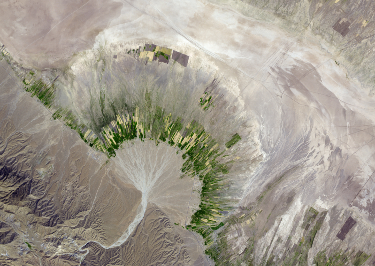
English: Seasonally dry salt lakes and the traces of ephemeral streams occupy many of the valleys of the Zagros Mountains in southern Iran. Much of the time, the rivers and lakes are dry above ground, but subterranean water flows along the same pathways. Where these subterranean streams flow out of the mountains, the water table comes closer to the surface, and it is more readily accessible through wells.
This simulated natural-color image of southeastern Fars province in southern Iran shows a dry river channel carving through arid mountains toward the northeast. The dry river spreads out across the valley floor in a silvery fan. A broad belt of lush agricultural land follows the curve of the fan and stretches out along a road that runs parallel to the ridgeline. The valley-ward margin of the intensely green agricultural belt fades to dull green along streams (or irrigation canals). The image was captured by the Advanced Spaceborne Thermal Emission and Reflection Radiometer (ASTER) on NASA’s Terra satellite on October 12, 2004. |
| நாள் | |
| மூலம் | http://earthobservatory.nasa.gov/IOTD/view.php?id=36041 |
| ஆசிரியர் | NASA image created by Jesse Allen, using data from NASA/GSFC/METI/ERSDAC/JAROS, and the U.S./Japan ASTER Science Team. Caption by Rebecca Lindsey, based on interpretation provided on the ASTER Project Science Imagery Gallery Website. |
அனுமதி
| This file is in the public domain in the United States because it was solely created by NASA. NASA copyright policy states that "NASA material is not protected by copyright unless noted". (See Template:PD-USGov, NASA copyright policy page or JPL Image Use Policy.) | ||
 |
Warnings:
|
கோப்பின் வரலாறு
குறித்த நேரத்தில் இருந்த படிமத்தைப் பார்க்க அந்நேரத்தின் மீது சொடுக்கவும்.
| நாள்/நேரம் | நகம் அளவு சிறுபடம் | அளவுகள் | பயனர் | கருத்து | |
|---|---|---|---|---|---|
| தற்போதைய | 19:38, 2 திசம்பர் 2018 | | 1,451 × 1,031 (704 KB) | Ariadacapo | Cropped 52 % horizontally, 57 % vertically using CropTool with lossless mode. |
| 19:36, 2 திசம்பர் 2018 |  | 3,000 × 2,400 (3.22 MB) | Ariadacapo | Full-size original from source | |
| 00:27, 17 பெப்பிரவரி 2010 |  | 720 × 480 (300 KB) | File Upload Bot (Magnus Manske) | {{BotMoveToCommons|en.wikipedia|year={{subst:CURRENTYEAR}}|month={{subst:CURRENTMONTHNAME}}|day={{subst:CURRENTDAY}}}} {{Information |Description={{en|Alluvial Fan in Southern Iran NASA image created by Jesse Allen, using data from NASA/GSFC/METI/ERSDAC |
கோப்பு பயன்பாடு
பின்வரும் 2 பக்கங்கள் இணைப்பு இப் படிமத்துக்கு இணைக்கபட்டுள்ளது(ளன):
கோப்பின் முழுமையான பயன்பாடு
கீழ்கண்ட மற்ற விக்கிகள் இந்த கோப்பை பயன்படுத்துகின்றன:
- bs.wikipedia.org-திட்டத்தில் இதன் பயன்பாடு
- ca.wikipedia.org-திட்டத்தில் இதன் பயன்பாடு
- en.wikipedia.org-திட்டத்தில் இதன் பயன்பாடு
- en.wikibooks.org-திட்டத்தில் இதன் பயன்பாடு
- fa.wikipedia.org-திட்டத்தில் இதன் பயன்பாடு
- gl.wikipedia.org-திட்டத்தில் இதன் பயன்பாடு
- he.wikipedia.org-திட்டத்தில் இதன் பயன்பாடு
- hr.wikipedia.org-திட்டத்தில் இதன் பயன்பாடு
- hu.wikipedia.org-திட்டத்தில் இதன் பயன்பாடு
- it.wikibooks.org-திட்டத்தில் இதன் பயன்பாடு
- it.wikiversity.org-திட்டத்தில் இதன் பயன்பாடு
- nl.wikipedia.org-திட்டத்தில் இதன் பயன்பாடு
- ru.wikipedia.org-திட்டத்தில் இதன் பயன்பாடு
- sh.wikipedia.org-திட்டத்தில் இதன் பயன்பாடு
- simple.wikipedia.org-திட்டத்தில் இதன் பயன்பாடு
- sl.wikipedia.org-திட்டத்தில் இதன் பயன்பாடு
- sr.wikipedia.org-திட்டத்தில் இதன் பயன்பாடு
- th.wikipedia.org-திட்டத்தில் இதன் பயன்பாடு
- tr.wikipedia.org-திட்டத்தில் இதன் பயன்பாடு