
படிமம்:9 dotted line.png

இந்த முன்னோட்டத்தின் அளவு: 487 × 600 படப்புள்ளிகள் . மற்ற பிரிதிறன்கள்: 195 × 240 படப்புள்ளிகள் | 390 × 480 படப்புள்ளிகள் | 979 × 1,206 படப்புள்ளிகள் .
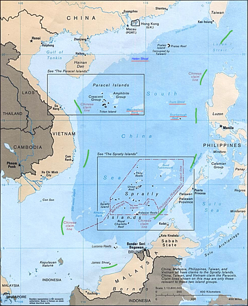
மூலக்கோப்பு (979 × 1,206 படவணுக்கள், கோப்பின் அளவு: 1.79 MB, MIME வகை: image/png)
| இது விக்கிமீடியா பொதுக்கோப்பகத்தில் இருக்கும் ஒரு கோப்பாகும். இக்கோப்பைக் குறித்து அங்கே காணப்படும் படிம விளக்கப் பக்கத்தை இங்கே கீழே காணலாம்.
|
சுருக்கம்
| விளக்கம் |
English: Map of the South China Sea, with 9-dotted line highlighted in green |
| நாள் | |
| மூலம் | Asia Maps — Perry-Castañeda Map Collection: South China Sea (Islands) 1988 |
| ஆசிரியர் | U.S. Central Intelligence Agency |
| ஒத்தக்கோப்பு | file:Schina_sea_88.png |
அனுமதி
| This image is a work of a Central Intelligence Agency employee, taken or made as part of that person's official duties. As a Work of the United States Government, this image or media is in the public domain in the United States.
|

|
Original upload log
The original description page was here. All following user names refer to en.wikipedia.
- 2011-10-20 18:05 JasonAQuest 979×1206× (1880133 bytes) {{Information |Description=Map of the South China Sea, with 9-dotted line highlighted in green |Source=[http://www.lib.utexas.edu/maps/asia.html Asia Maps — Perry-Castañeda Map Collection]: South China Sea (Islands) 1988 |Date=1988 |Author=U.S. Central Intelligence Agency |Permission={{PD-USGov-CIA}} |other_versions=Schina sea 88.png }} [[Category:South China Sea]] [[Category:Spratly Islands]] [[Category:Paracel Islands]]
கோப்பின் வரலாறு
குறித்த நேரத்தில் இருந்த படிமத்தைப் பார்க்க அந்நேரத்தின் மீது சொடுக்கவும்.
| நாள்/நேரம் | நகம் அளவு சிறுபடம் | அளவுகள் | பயனர் | கருத்து | |
|---|---|---|---|---|---|
| தற்போதைய | 22:29, 21 அக்டோபர் 2011 | | 979 × 1,206 (1.79 MB) | Cantons-de-l'Est | {{Information |Description={{en|Map of the South China Sea, with 9-dotted line highlighted in green<br/> en:Category:South China Sea en:Category:Spratly Islands en:Category:Paracel Islands}} |Source=Transferred from [http://en.wikipedia. |
கோப்பு பயன்பாடு
பின்வரும் பக்க இணைப்புகள் இப் படிமத்துக்கு இணைக்கபட்டுள்ளது(ளன):
கோப்பின் முழுமையான பயன்பாடு
கீழ்கண்ட மற்ற விக்கிகள் இந்த கோப்பை பயன்படுத்துகின்றன:
- ar.wikipedia.org-திட்டத்தில் இதன் பயன்பாடு
- az.wikipedia.org-திட்டத்தில் இதன் பயன்பாடு
- ca.wikipedia.org-திட்டத்தில் இதன் பயன்பாடு
- cs.wikipedia.org-திட்டத்தில் இதன் பயன்பாடு
- de.wikipedia.org-திட்டத்தில் இதன் பயன்பாடு
- en.wikipedia.org-திட்டத்தில் இதன் பயன்பாடு
- es.wikipedia.org-திட்டத்தில் இதன் பயன்பாடு
- it.wikipedia.org-திட்டத்தில் இதன் பயன்பாடு
- ja.wikipedia.org-திட்டத்தில் இதன் பயன்பாடு
- ko.wikipedia.org-திட்டத்தில் இதன் பயன்பாடு
- no.wikipedia.org-திட்டத்தில் இதன் பயன்பாடு
- pl.wikipedia.org-திட்டத்தில் இதன் பயன்பாடு
- pt.wikipedia.org-திட்டத்தில் இதன் பயன்பாடு
- ru.wikipedia.org-திட்டத்தில் இதன் பயன்பாடு
- sv.wikipedia.org-திட்டத்தில் இதன் பயன்பாடு
- th.wikipedia.org-திட்டத்தில் இதன் பயன்பாடு
- tr.wikipedia.org-திட்டத்தில் இதன் பயன்பாடு
- uk.wikipedia.org-திட்டத்தில் இதன் பயன்பாடு
- www.wikidata.org-திட்டத்தில் இதன் பயன்பாடு
- zh.wikipedia.org-திட்டத்தில் இதன் பயன்பாடு
- zh.wikinews.org-திட்டத்தில் இதன் பயன்பாடு