உள்ளடக்கத்துக்குச் செல்

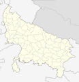
படிமம்:India Uttar Pradesh districts 2012.svg

மற்ற மொழிகளில் ஆதரிக்கப்படாத பக்க உள்ளடக்கம்.
கட்டற்ற கலைக்களஞ்சியமான விக்கிப்பீடியாவில் இருந்து.

மூலக்கோப்பு(SVG கோப்பு, பெயரளவில் 2,379 × 2,466 பிக்சல்கள், கோப்பு அளவு: 128 KB)

இது விக்கிமீடியா பொதுக்கோப்பகத்தில் இருக்கும் ஒரு கோப்பாகும். இக்கோப்பைக் குறித்து அங்கே காணப்படும் படிம விளக்கப் பக்கத்தை இங்கே கீழே காணலாம்.
பொதுக்கோப்பகம் ஒரு கட்டற்ற கோப்புகளின் சேமிப்பகமாகும். நீங்களும் உதவலாம்.

சுருக்கம்

விளக்கம்
English: Locator map of the districts of Uttar Pradesh, India. Based on File:India Uttar Pradesh districts 2010.svg
நாள் (UTC)
மூலம் This file was derived from : India Uttar Pradesh districts 2010.svg
ஆசிரியர்


இது ஒரு திருத்தப்பட்ட படிமமாகும், அதாவது இதன் மூல வடிவத்திலிருந்து கணினி மூலம் இதில் மாற்றங்கள் செய்யப்பட்டுள்ளது. திருத்தங்கள்: update 2012. மூலக்கோப்பை இங்கு காணலாம்: India Uttar Pradesh districts 2010.svg. திருத்தங்களைச் செய்தவர் NordNordWest.

அனுமதி

இந்த ஆக்கத்தின் காப்புரிமையாளரான நான் இதனைப் பின்வரும் உரிமத்தின் கீழ் வெளியிடுகின்றேன்:
This work has been released into the public domain by its author, Example, at the [[::|ஆங்கிலம் விக்கிப்பீடியா]] project. This applies worldwide.

In case this is not legally possible:
Example grants anyone the right to use this work for any purpose, without any conditions, unless such conditions are required by law.

Original upload log

This image is a derivative work of the following images:

  • File:India_Uttar_Pradesh_districts_2010.svg licensed with PD-user-w
    • 2010-11-14T12:46:21Z Pitichinaccio 2379x2466 (127533 Bytes) small corr.
    • 2010-11-13T23:57:32Z Pitichinaccio 2379x2466 (127171 Bytes) {{Information |Description={{en|Locator map of the districts of Uttar Pradesh, India. Based on [[:File:Uttar Pradesh locator map.svg]]}} |Source=*[[:File:India_Uttar_Pradesh_districts.svg|]] |Date=2010-11-13 23:56 (UTC) |Auth

Captions

Add a one-line explanation of what this file represents

கோப்பின் வரலாறு

குறித்த நேரத்தில் இருந்த படிமத்தைப் பார்க்க அந்நேரத்தின் மீது சொடுக்கவும்.

நாள்/நேரம்நகம் அளவு சிறுபடம்அளவுகள்பயனர்கருத்து
தற்போதைய17:53, 4 மே 201217:53, 4 மே 2012 இலிருந்த பதிப்புக்கான சிறு தோற்றம்2,379 × 2,466 (128 KB)NordNordWestc
17:11, 4 மே 201217:11, 4 மே 2012 இலிருந்த பதிப்புக்கான சிறு தோற்றம்2,379 × 2,466 (99 KB)NordNordWest== {{int:filedesc}} == {{Information |Description={{en|Locator map of the districts of Uttar Pradesh, India. Based on File:Uttar Pradesh districts 2010.svg}} |Source={{Derived from|India_Uttar_Pradesh_districts_2010.svg|display=50}} |Date=2012-05-...

இப் படிமத்துக்கு இணைக்கப்பட்டுள்ள பக்கங்கள் எதுவும் இல்லை.

கோப்பின் முழுமையான பயன்பாடு

கீழ்கண்ட மற்ற விக்கிகள் இந்த கோப்பை பயன்படுத்துகின்றன:

"https://ta.wikipedia.org/wiki/படிமம்:India_Uttar_Pradesh_districts_2012.svg" இலிருந்து மீள்விக்கப்பட்டது