
படிமம்:Map of the Crimea.png

இந்த முன்னோட்டத்தின் அளவு: 800 × 520 படப்புள்ளிகள் . மற்ற பிரிதிறன்கள்: 320 × 208 படப்புள்ளிகள் | 640 × 416 படப்புள்ளிகள் | 1,024 × 666 படப்புள்ளிகள் | 1,280 × 833 படப்புள்ளிகள் | 2,283 × 1,485 படப்புள்ளிகள் .
மூலக்கோப்பு (2,283 × 1,485 படவணுக்கள், கோப்பின் அளவு: 984 KB, MIME வகை: image/png)
| இது விக்கிமீடியா பொதுக்கோப்பகத்தில் இருக்கும் ஒரு கோப்பாகும். இக்கோப்பைக் குறித்து அங்கே காணப்படும் படிம விளக்கப் பக்கத்தை இங்கே கீழே காணலாம்.
|
சுருக்கம்

|
This map image could be re-created using vector graphics as an SVG file. This has several advantages; see Commons:Media for cleanup for more information. If an SVG form of this image is available, please upload it and afterwards replace this template with
{{vector version available|new image name}}.
It is recommended to name the SVG file “Map of the Crimea.svg”—then the template Vector version available (or Vva) does not need the new image name parameter. |
| விளக்கம் |
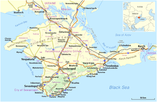
Deutsch: Karte der Krim, 2014
English: Map of the Crimea, 2014 |
|||
| நாள் | see file history | |||
| மூலம் |
சொந்த முயற்சி, using
|
|||
| ஆசிரியர் | Maximilian Dörrbecker (Chumwa) | |||
| அனுமதி (இக்கோப்பை மீண்டும் பயன்படுத்துதல்) |
This file is licensed under the Creative Commons Attribution-Share Alike 2.0 Generic license.
Sie dürfen das Bild zu den folgenden Bedingungen nutzen:
|
|||
| ஒத்தக்கோப்பு |
|


கோப்பின் வரலாறு
குறித்த நேரத்தில் இருந்த படிமத்தைப் பார்க்க அந்நேரத்தின் மீது சொடுக்கவும்.
| நாள்/நேரம் | நகம் அளவு சிறுபடம் | அளவுகள் | பயனர் | கருத்து | |
|---|---|---|---|---|---|
| தற்போதைய | 06:20, 22 மார்ச்சு 2014 | | 2,283 × 1,485 (984 KB) | Chumwa | == {{int:filedesc}} == {{Information |Description = {{de|1=Karte der Krim}} {{en|1=Map of the Crimea}} |Source={{own}}, using * OpenStreetMap data * this file for the orientation map inset |Date = see fil... |
கோப்பு பயன்பாடு
பின்வரும் பக்க இணைப்புகள் இப் படிமத்துக்கு இணைக்கபட்டுள்ளது(ளன):
கோப்பின் முழுமையான பயன்பாடு
கீழ்கண்ட மற்ற விக்கிகள் இந்த கோப்பை பயன்படுத்துகின்றன:
- az.wikipedia.org-திட்டத்தில் இதன் பயன்பாடு
- be.wikipedia.org-திட்டத்தில் இதன் பயன்பாடு
- bg.wikipedia.org-திட்டத்தில் இதன் பயன்பாடு
- ce.wikipedia.org-திட்டத்தில் இதன் பயன்பாடு
- cs.wikipedia.org-திட்டத்தில் இதன் பயன்பாடு
- da.wikipedia.org-திட்டத்தில் இதன் பயன்பாடு
- en.wikipedia.org-திட்டத்தில் இதன் பயன்பாடு
- Crimea
- Transfer of Crimea in the Soviet Union
- International reactions to the annexation of Crimea by the Russian Federation
- Autonomous Republic of Crimea
- Template:Annexation of Crimea in 2014 sidebar
- Partition Treaty on the Status and Conditions of the Black Sea Fleet
- Annexation of Crimea by the Russian Federation
- Crimean speech of Vladimir Putin
- User:MyMoloboaccount/Crimea
- Russian–Ukrainian Friendship Treaty
- en.wiktionary.org-திட்டத்தில் இதன் பயன்பாடு
- eo.wikipedia.org-திட்டத்தில் இதன் பயன்பாடு
- es.wikipedia.org-திட்டத்தில் இதன் பயன்பாடு
- et.wikipedia.org-திட்டத்தில் இதன் பயன்பாடு
- fr.wikipedia.org-திட்டத்தில் இதன் பயன்பாடு
- hy.wikipedia.org-திட்டத்தில் இதன் பயன்பாடு
- hyw.wikipedia.org-திட்டத்தில் இதன் பயன்பாடு
- id.wikipedia.org-திட்டத்தில் இதன் பயன்பாடு
- it.wikipedia.org-திட்டத்தில் இதன் பயன்பாடு
- kk.wikipedia.org-திட்டத்தில் இதன் பயன்பாடு
- ku.wikipedia.org-திட்டத்தில் இதன் பயன்பாடு
- lfn.wikipedia.org-திட்டத்தில் இதன் பயன்பாடு
- lo.wikipedia.org-திட்டத்தில் இதன் பயன்பாடு
- mk.wikipedia.org-திட்டத்தில் இதன் பயன்பாடு
- ml.wikipedia.org-திட்டத்தில் இதன் பயன்பாடு
- ms.wikipedia.org-திட்டத்தில் இதன் பயன்பாடு
- nds.wikipedia.org-திட்டத்தில் இதன் பயன்பாடு
- no.wikipedia.org-திட்டத்தில் இதன் பயன்பாடு
- nso.wikipedia.org-திட்டத்தில் இதன் பயன்பாடு
- pt.wikipedia.org-திட்டத்தில் இதன் பயன்பாடு
- ro.wikipedia.org-திட்டத்தில் இதன் பயன்பாடு
- ru.wikipedia.org-திட்டத்தில் இதன் பயன்பாடு
- scn.wikipedia.org-திட்டத்தில் இதன் பயன்பாடு
- sd.wikipedia.org-திட்டத்தில் இதன் பயன்பாடு
- sh.wikipedia.org-திட்டத்தில் இதன் பயன்பாடு
- sl.wikipedia.org-திட்டத்தில் இதன் பயன்பாடு
- tr.wikipedia.org-திட்டத்தில் இதன் பயன்பாடு
- uk.wikipedia.org-திட்டத்தில் இதன் பயன்பாடு
சிறப்பு பக்கம்-மொத்த பயன்பாடு - இதன் மூலம் இந்த கோப்பின் மொத்த பயன்பாட்டை அறிய முடியும்