
படிமம்:Map of Russia - Far Eastern Federal District (2018 composition).svg

Size of this PNG preview of this SVG file: 800 × 462 படப்புள்ளிகள். மற்ற பிரிதிறன்கள்: 320 × 185 படப்புள்ளிகள் | 640 × 369 படப்புள்ளிகள் | 1,024 × 591 படப்புள்ளிகள் | 1,280 × 738 படப்புள்ளிகள் | 2,560 × 1,477 படப்புள்ளிகள் | 1,092 × 630 படப்புள்ளிகள் .
மூலக்கோப்பு (SVG கோப்பு, பெயரளவில் 1,092 × 630 பிக்சல்கள், கோப்பு அளவு: 61 KB)
| இது விக்கிமீடியா பொதுக்கோப்பகத்தில் இருக்கும் ஒரு கோப்பாகும். இக்கோப்பைக் குறித்து அங்கே காணப்படும் படிம விளக்கப் பக்கத்தை இங்கே கீழே காணலாம்.
|
.svg)

|
The boundaries on this map show the de facto situation. This is just one of several different views on the subject (see COM:NPOV). |
சுருக்கம்
| விளக்கம் |
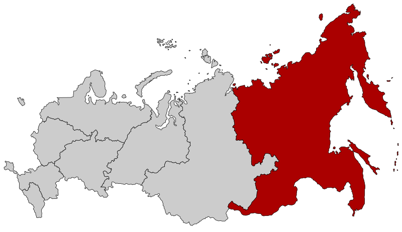
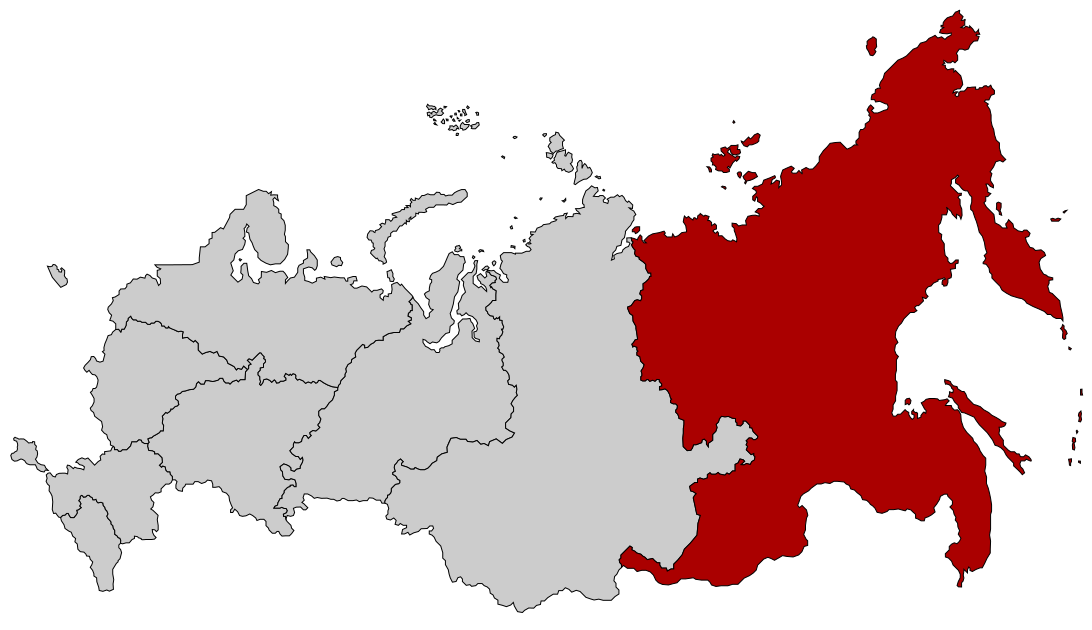
English: Map Russia highlighting the Far Eastern Federal district as of 2018-11-03. Español: Ubicación del Distrito Federal de Lejano Oriente en la Federación Rusa Русский: Дальневосточный федеральный округ |
| நாள் | (UTC) |
| மூலம் |
This file was derived from: |
| ஆசிரியர் |
| இது ஒரு திருத்தப்பட்ட படிமமாகும், அதாவது இதன் மூல வடிவத்திலிருந்து கணினி மூலம் இதில் மாற்றங்கள் செய்யப்பட்டுள்ளது. திருத்தங்கள்: Added Buryatia and Zabaykalsky Krai. மூலக்கோப்பை இங்கு காணலாம்: Map of Russia - Far Eastern Federal District.svg. திருத்தங்களைச் செய்தவர் Seryo93.
|
அனுமதி
This file is licensed under the Creative Commons Attribution-Share Alike 2.5 Generic license.
- நீங்கள் சுதந்திரமாக:
- பகிர்ந்து கொள்ள – வேலையை நகலெடுக்க, விநியோகிக்க மற்றும் அனுப்ப
- மீண்டும் கலக்க – வேலைக்கு பழகிக்கொள்ள.
- கீழ்க்காணும் விதிகளுக்கு ஏற்ப,
- பண்புக்கூறுகள் – நீங்கள் பொருத்தமான உரிமையை வழங்க வேண்டும், உரிமத்திற்கான இணைப்பை வழங்க வேண்டும் மற்றும் மாற்றங்கள் செய்யப்பட்டிருந்தால் குறிப்பிட வேண்டும். நீங்கள் ஏற்புடைய எந்த முறையிலும் அவ்வாறு செய்யலாம், ஆனால் எந்த வகையிலும் உரிமதாரர் உங்களை அல்லது உங்கள் பயன்பாட்டிற்கு ஒப்புதல் அளிக்கும் படி பரிந்துரைக்க கூடாது.
- அதே மாதிரி பகிர் – நீங்கள் ரீமிக்ஸ் செய்தாலோ, உருமாற்றம் செய்தாலோ அல்லது பொருளை உருவாக்கினாலோ, உங்கள் பங்களிப்புகளை அல்லது இணக்கமான உரிமம் கீழ் அசலாக விநியோகிக்க வேண்டும்.
Original upload log
This image is a derivative work of the following images:
- File:Map of Russia - Far Eastern Federal District.svg licensed with Cc-by-sa-2.5
- 2018-11-04T19:12:00Z Seryo93 1092x630 (97483 Bytes) Reverted to version as of 14:21, 10 March 2015 (UTC): will upload separately
- 2018-11-04T19:11:17Z Seryo93 1092x630 (62312 Bytes) cleanup
- 2018-11-04T19:04:20Z Seryo93 1092x630 (287327 Bytes) Update from [[:File:Map_of_Russian_districts,_2018-11-04.svg]]
- 2015-03-10T14:21:00Z Knyaz-1988 1092x630 (97483 Bytes) Reverted to version as of 22:12, 3 November 2014
- 2014-11-04T01:32:51Z Fry1989 1092x630 (120531 Bytes) NPOV issue.
- 2014-11-03T22:12:44Z Knyaz-1988 1092x630 (97483 Bytes) New version
- 2010-01-22T20:29:49Z Denhud 1092x630 (120531 Bytes) On 2010-01-19 Southern Federal District split in two, with its former southern territories forming new North Caucasian Federal District.
- 2010-01-21T22:25:25Z Denhud 1092x630 (120531 Bytes) On 2010-01-19 Southern Federal District split in two, with its former southern territories forming new North Caucasian Federal District.
- 2008-03-03T23:36:42Z Lokal Profil 1092x630 (114976 Bytes) {{Information |Description=Map Russia highlighting the Far Eastern [[:en:Federal districts of Russia|Federal districts]]. |Source=Based on [[:Image:Map of Russian subjects, 2008-03-01.svg|Map of Russian subjects, 2008-03-01.s
- File:Map of Russian districts, 2018-11-04.svg licensed with Cc-by-sa-2.5
Uploaded with derivativeFX
கோப்பின் வரலாறு
குறித்த நேரத்தில் இருந்த படிமத்தைப் பார்க்க அந்நேரத்தின் மீது சொடுக்கவும்.
| நாள்/நேரம் | நகம் அளவு சிறுபடம் | அளவுகள் | பயனர் | கருத்து | |
|---|---|---|---|---|---|
| தற்போதைய | 19:15, 4 நவம்பர் 2018 | | 1,092 × 630 (61 KB) | Seryo93 | == {{int:filedesc}} == {{Information |Description={{en|Map Russia highlighting the '''Far Eastern Federal district''' as of 2018-11-03.}} {{es|Ubicación del Distrito Federal de Lejano Oriente en la Federación Rusa}} {{Ru|Дальневосточный федеральный округ}} |Source={{Derived from|Map of Russia - Far Eastern Federal District.svg|Map of Russian districts, 2018-11-04.svg|display=50}} |Date=2018-11-04 19:14 (UTC) |Author=* [[:File:Map of Russia - Far Eastern Fed... |
கோப்பு பயன்பாடு
பின்வரும் பக்க இணைப்புகள் இப் படிமத்துக்கு இணைக்கபட்டுள்ளது(ளன):
கோப்பின் முழுமையான பயன்பாடு
கீழ்கண்ட மற்ற விக்கிகள் இந்த கோப்பை பயன்படுத்துகின்றன:
- ar.wikipedia.org-திட்டத்தில் இதன் பயன்பாடு
- ast.wikipedia.org-திட்டத்தில் இதன் பயன்பாடு
- az.wikipedia.org-திட்டத்தில் இதன் பயன்பாடு
- be-tarask.wikipedia.org-திட்டத்தில் இதன் பயன்பாடு
- ca.wikipedia.org-திட்டத்தில் இதன் பயன்பாடு
- cs.wikipedia.org-திட்டத்தில் இதன் பயன்பாடு
- cv.wikipedia.org-திட்டத்தில் இதன் பயன்பாடு
- el.wikipedia.org-திட்டத்தில் இதன் பயன்பாடு
- en.wikipedia.org-திட்டத்தில் இதன் பயன்பாடு
- Russian Far East
- Far Eastern Federal District
- Category:Russian Far East
- User:Paukrus
- User:Paukrus/Userbox
- User:Paukrus/Userbox/Russian Far East
- User:Profwill
- User:Glucke
- Category:Geography of the Russian Far East
- Category:Landforms of the Russian Far East
- User:Antanaklasis
- Category:Far Eastern Federal District
- User:Weneedwikipedia
- Wikipedia:Userboxes/Location/Russia
- User:Dikivan2000
- en.wikinews.org-திட்டத்தில் இதன் பயன்பாடு
- eo.wikipedia.org-திட்டத்தில் இதன் பயன்பாடு
- et.wikipedia.org-திட்டத்தில் இதன் பயன்பாடு
- fi.wikipedia.org-திட்டத்தில் இதன் பயன்பாடு
சிறப்பு பக்கம்-மொத்த பயன்பாடு - இதன் மூலம் இந்த கோப்பின் மொத்த பயன்பாட்டை அறிய முடியும்
.svg)
.svg)