
படிமம்:Map Canada political 2.png

இந்த முன்னோட்டத்தின் அளவு: 693 × 599 படப்புள்ளிகள் . மற்ற பிரிதிறன்கள்: 278 × 240 படப்புள்ளிகள் | 555 × 480 படப்புள்ளிகள் | 888 × 768 படப்புள்ளிகள் | 1,184 × 1,024 படப்புள்ளிகள் | 1,280 × 1,107 படப்புள்ளிகள் .
மூலக்கோப்பு (1,280 × 1,107 படவணுக்கள், கோப்பின் அளவு: 387 KB, MIME வகை: image/png)
| இது விக்கிமீடியா பொதுக்கோப்பகத்தில் இருக்கும் ஒரு கோப்பாகும். இக்கோப்பைக் குறித்து அங்கே காணப்படும் படிம விளக்கப் பக்கத்தை இங்கே கீழே காணலாம்.
|
| விளக்கம் |
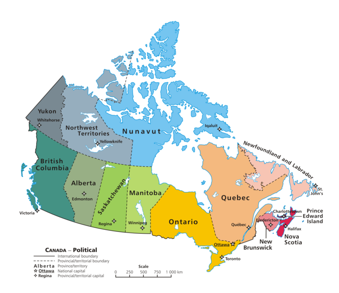
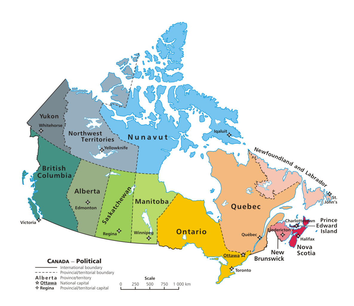
English: A map of Canada exhibiting its ten provinces and three territories, and their capitals. |
| நாள் | (UTC) |
| மூலம் | |
| ஆசிரியர் |
|
| இது ஒரு திருத்தப்பட்ட படிமமாகும், அதாவது இதன் மூல வடிவத்திலிருந்து கணினி மூலம் இதில் மாற்றங்கள் செய்யப்பட்டுள்ளது. திருத்தங்கள்: + PNG transparency outline. மூலக்கோப்பை இங்கு காணலாம்: Map Canada political.png. திருத்தங்களைச் செய்தவர் GIMP.
|
இந்த ஆக்கத்தின் காப்புரிமையாளரான நான் இதனைப் பின்வரும் உரிமத்தின் கீழ் வெளியிடுகின்றேன்:
| |
This work has been released into the public domain by its author, Example, at the [[::|ஆங்கிலம் விக்கிப்பீடியா]] project. This applies worldwide. In case this is not legally possible: |
Original upload log
This image is a derivative work of the following images:
- File:Map_Canada_political.png licensed with PD-user-w
- 2007-06-13T02:50:40Z Andrew pmk 1280x1107 (250520 Bytes) optimize png
- 2007-06-06T01:38:46Z Andrew pmk 1280x1107 (250520 Bytes) optimize png
- 2006-06-06T09:35:23Z Kaveh 1280x1107 (302665 Bytes) == Summary == [[Canada]]: political map – depicting |provinces/territories and capital cities. Drawn and adapted by [[:en:User:E Pluribus Anthony|E Pluribus Anthony]] from [http://atlas.gc.ca/site/english/maps/reference/n
Uploaded with derivativeFX
கோப்பின் வரலாறு
குறித்த நேரத்தில் இருந்த படிமத்தைப் பார்க்க அந்நேரத்தின் மீது சொடுக்கவும்.
| நாள்/நேரம் | நகம் அளவு சிறுபடம் | அளவுகள் | பயனர் | கருத்து | |
|---|---|---|---|---|---|
| தற்போதைய | 03:08, 7 பெப்பிரவரி 2010 | | 1,280 × 1,107 (387 KB) | Merosonox~commonswiki | {{Information |Description={{en|1=A map of Canada exhibiting its ten provinces and three territories, and their capitals.}} |Source=*File:Map_Canada_political.png |Date=2010-02-07 03:06 (UTC) |Author=*File:Map_Canada_political.png: [[:en:User: |
கோப்பு பயன்பாடு
பின்வரும் பக்க இணைப்புகள் இப் படிமத்துக்கு இணைக்கபட்டுள்ளது(ளன):
கோப்பின் முழுமையான பயன்பாடு
கீழ்கண்ட மற்ற விக்கிகள் இந்த கோப்பை பயன்படுத்துகின்றன:
- diq.wikipedia.org-திட்டத்தில் இதன் பயன்பாடு
- tr.wikipedia.org-திட்டத்தில் இதன் பயன்பாடு
- Kanada
- Şablon:Kanada'nın eyaletleri ve bölgeleri
- Manitoba
- Saskatchewan
- Ontario
- Kategori:Kanada'nın eyaletleri
- Prens Edward Adası
- New Brunswick
- Québec
- Alberta
- Yeni İskoçya
- Newfoundland ve Labrador
- Yukon
- Kuzeybatı Toprakları
- Nunavut
- Kanada'nın eyaletleri ve bölgeleri
- Kategori:Kanada'nın eyaletleri ve bölgeleri
- Kategori:Kanada'nın bölgeleri
- Banks Adası
- Britanya Kolumbiyası
- Saint-Maurice—Laflèche