
படிமம்:Map Canada political-geo.png

இந்த முன்னோட்டத்தின் அளவு: 680 × 599 படப்புள்ளிகள் . மற்ற பிரிதிறன்கள்: 272 × 240 படப்புள்ளிகள் | 545 × 480 படப்புள்ளிகள் | 872 × 768 படப்புள்ளிகள் | 1,162 × 1,024 படப்புள்ளிகள் | 1,280 × 1,128 படப்புள்ளிகள் .
மூலக்கோப்பு (1,280 × 1,128 படவணுக்கள், கோப்பின் அளவு: 492 KB, MIME வகை: image/png)
| இது விக்கிமீடியா பொதுக்கோப்பகத்தில் இருக்கும் ஒரு கோப்பாகும். இக்கோப்பைக் குறித்து அங்கே காணப்படும் படிம விளக்கப் பக்கத்தை இங்கே கீழே காணலாம்.
|
சுருக்கம்
| விளக்கம் |
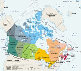
Map: Canada – geopolitical Drawn and adapted by E Pluribus Anthony from Atlas of Canada Edited by en:User:Heqs/en:User:Cogito ergo sumo to show disputed nature of Canada's marine international boundary claims; see en:Canada-United_States_border#Remaining_boundary_disputes; further edited by Bosonic dressing to reflect agreed maritime boundary between Canada and Greenland/Denmark: see http://www.dur.ac.uk/resources/ibru/arctic.pdf |
| நாள் | 11 மார்ச்சு 2006 (original upload date) |
| மூலம் | Originally from en.wikipedia; description page is/was here. |
| ஆசிரியர் |
Original uploader was E Pluribus Anthony at en.wikipedia Later versions were uploaded by AThing, Heqs, Cogito ergo sumo at en.wikipedia. |
| அனுமதி (இக்கோப்பை மீண்டும் பயன்படுத்துதல்) |
Released into the public domain (by the author). |
| ஒத்தக்கோப்பு | Derivative works of this file: Map Canada political-geo-be-x-old.png |
அனுமதி
| |
This work has been released into the public domain by its author, E Pluribus Anthony, at the ஆங்கிலம் விக்கிப்பீடியா project. This applies worldwide. In case this is not legally possible: |
கோப்பின் வரலாறு
குறித்த நேரத்தில் இருந்த படிமத்தைப் பார்க்க அந்நேரத்தின் மீது சொடுக்கவும்.
| நாள்/நேரம் | நகம் அளவு சிறுபடம் | அளவுகள் | பயனர் | கருத்து | |
|---|---|---|---|---|---|
| தற்போதைய | 07:37, 8 நவம்பர் 2008 | | 1,280 × 1,128 (492 KB) | Bosonic dressing | {{Information |Description=Map of Canada, revised to reflect agreed border with Greenland/Denmark, per http://www.dur.ac.uk/resources/ibru/arctic.pdf |Source= |Date=8 November 2008 |Author=E Pluribus Anthony, et al |Permission= |other_versions= }} |
| 07:33, 8 நவம்பர் 2008 |  | 1,280 × 1,297 (529 KB) | Bosonic dressing | {{Information |Description=Map of Canada, revised to reflect agreed border with Greenland/Denamrk, per http://www.dur.ac.uk/resources/ibru/arctic.pdf |Source= |Date=8 November 2008 |Author=E Pluribus Anthony, et al |Permission= |other_versions= }} | |
| 19:54, 15 சூன் 2007 |  | 1,280 × 1,128 (496 KB) | PMG | {{Information |Description=Map: en:Canada – geopolitical Drawn and adapted by E Pluribus Anthony from [http://atlas.gc.ca/site/english/maps/reference/national/can_political_e Atlas of Canada] Edited by [[:en:User:H |
கோப்பு பயன்பாடு
இப் படிமத்துக்கு இணைக்கப்பட்டுள்ள பக்கங்கள் எதுவும் இல்லை.
கோப்பின் முழுமையான பயன்பாடு
கீழ்கண்ட மற்ற விக்கிகள் இந்த கோப்பை பயன்படுத்துகின்றன:
- ace.wikipedia.org-திட்டத்தில் இதன் பயன்பாடு
- ar.wikipedia.org-திட்டத்தில் இதன் பயன்பாடு
- cu.wikipedia.org-திட்டத்தில் இதன் பயன்பாடு
- cy.wikipedia.org-திட்டத்தில் இதன் பயன்பாடு
- da.wikipedia.org-திட்டத்தில் இதன் பயன்பாடு
- de.wikipedia.org-திட்டத்தில் இதன் பயன்பாடு
- de.wikivoyage.org-திட்டத்தில் இதன் பயன்பாடு
- en.wikipedia.org-திட்டத்தில் இதன் பயன்பாடு
- Talk:Ottawa
- Talk:Montreal
- Talk:Toronto
- Talk:Whatì
- Talk:Brampton
- Talk:Emerald Park, Saskatchewan
- Wikipedia talk:WikiProject Toronto
- Talk:St. John's, Newfoundland and Labrador
- Talk:North Bay, Ontario
- Talk:List of communities in Quebec
- Talk:Saguenay, Quebec
- Talk:List of cities in Canada
- Talk:Carleton Place
- Talk:London, Ontario
- Talk:St. Catharines
- Talk:Etobicoke
- Talk:Inuvik
- Talk:Tulita
- Talk:Surrey, British Columbia
- Talk:Montreal, Quebec
- Talk:100 Mile House
- Talk:Timmins
- Talk:Mississauga/Archive 2
- Talk:King, Ontario
- Talk:Medicine Hat
- Talk:Bramalea, Ontario
- Talk:Elliot Lake
- Index of Canada-related articles
- Talk:List of unincorporated communities in Ontario
- Talk:Vancouver
- Talk:Coquitlam
- Talk:Regent Park
- Talk:The Peanut
- Talk:List of the largest municipalities in Canada by population
- Talk:Thornhill, Ontario
- Talk:Kitchener, Ontario
சிறப்பு பக்கம்-மொத்த பயன்பாடு - இதன் மூலம் இந்த கோப்பின் மொத்த பயன்பாட்டை அறிய முடியும்