
படிமம்:Mao Kun map - Singapore.png

இந்த முன்னோட்டத்தின் அளவு: 799 × 344 படப்புள்ளிகள் . மற்ற பிரிதிறன்கள்: 320 × 138 படப்புள்ளிகள் | 640 × 276 படப்புள்ளிகள் | 1,289 × 555 படப்புள்ளிகள் .
மூலக்கோப்பு (1,289 × 555 படவணுக்கள், கோப்பின் அளவு: 473 KB, MIME வகை: image/png)
| இது விக்கிமீடியா பொதுக்கோப்பகத்தில் இருக்கும் ஒரு கோப்பாகும். இக்கோப்பைக் குறித்து அங்கே காணப்படும் படிம விளக்கப் பக்கத்தை இங்கே கீழே காணலாம்.
|
சுருக்கம்
| விளக்கம் |
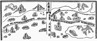
English: A Mao Kun map showing Singapore and part of the east coast of the Malay peninsula. Temasek (early Singapore; " 淡馬錫 ) is marked at the top left corner, others identified by Wheatley are Pulau Brani (琵琶嶼), Blakang Mati (長腰嶼, Sentosa), Pedra Branca (白礁), Pulau Tinggi (將軍帽), Pulau Aur (東竹山 and 西竹山), Pahang River estuary (彭杭港), and Pulau Tioman (苧麻山). Long Ya Men (龍牙門) on the map is said to mark the entrance to Keppel Harbour. Note that different sources may identify the islands differently, especially the islands of Singapore. J. V. G. Mills for example identified 長腰嶼 as Pulau Satumu and 琵琶嶼 as Pulau Sakijang Pelepah. |
| நாள் | 17 century |
| மூலம் | Scanned from Paul Wheatley (1961) The Golden Khersonese: Studies in the Historical Geography of the Malay Peninsula before A.D. 1500, கோலாலம்பூர்: University of Malaya Press OCLC: 504030596. Originally from the Wubei Zhi (Treatise on Armament Technology), a 17th century work with maps based on material dated to the voyages of Zheng He (early 15th century). |
| ஆசிரியர் | Mao Yuanyi (1594–1640?), editor of the Wubei Zhi; and an unknown cartographer. |
அனுமதி
|
This is a faithful photographic reproduction of a two-dimensional, public domain work of art. The work of art itself is in the public domain for the following reason:
The official position taken by the Wikimedia Foundation is that "faithful reproductions of two-dimensional public domain works of art are public domain".
This photographic reproduction is therefore also considered to be in the public domain in the United States. In other jurisdictions, re-use of this content may be restricted; see Reuse of PD-Art photographs for details. | ||||
கோப்பின் வரலாறு
குறித்த நேரத்தில் இருந்த படிமத்தைப் பார்க்க அந்நேரத்தின் மீது சொடுக்கவும்.
| நாள்/நேரம் | நகம் அளவு சிறுபடம் | அளவுகள் | பயனர் | கருத்து | |
|---|---|---|---|---|---|
| தற்போதைய | 14:42, 30 சூலை 2015 | | 1,289 × 555 (473 KB) | Hzh | User created page with UploadWizard |
கோப்பு பயன்பாடு
பின்வரும் 2 பக்கங்கள் இணைப்பு இப் படிமத்துக்கு இணைக்கபட்டுள்ளது(ளன):
கோப்பின் முழுமையான பயன்பாடு
கீழ்கண்ட மற்ற விக்கிகள் இந்த கோப்பை பயன்படுத்துகின்றன:
- cs.wikipedia.org-திட்டத்தில் இதன் பயன்பாடு
- en.wikipedia.org-திட்டத்தில் இதன் பயன்பாடு
- id.wikipedia.org-திட்டத்தில் இதன் பயன்பாடு
- it.wikipedia.org-திட்டத்தில் இதன் பயன்பாடு
- ko.wikipedia.org-திட்டத்தில் இதன் பயன்பாடு
- ms.wikipedia.org-திட்டத்தில் இதன் பயன்பாடு
- ru.wikipedia.org-திட்டத்தில் இதன் பயன்பாடு
- th.wikipedia.org-திட்டத்தில் இதன் பயன்பாடு
- tl.wikipedia.org-திட்டத்தில் இதன் பயன்பாடு
- uk.wikipedia.org-திட்டத்தில் இதன் பயன்பாடு
- zh.wikipedia.org-திட்டத்தில் இதன் பயன்பாடு