
படிமம்:Delian League Campaign Map.png
இதைவிட அளவில் பெரிய படிமம் இல்லை.
Delian_League_Campaign_Map.png (500 × 500 படவணுக்கள், கோப்பின் அளவு: 526 KB, MIME வகை: image/png)
| இது விக்கிமீடியா பொதுக்கோப்பகத்தில் இருக்கும் ஒரு கோப்பாகும். இக்கோப்பைக் குறித்து அங்கே காணப்படும் படிம விளக்கப் பக்கத்தை இங்கே கீழே காணலாம்.
|
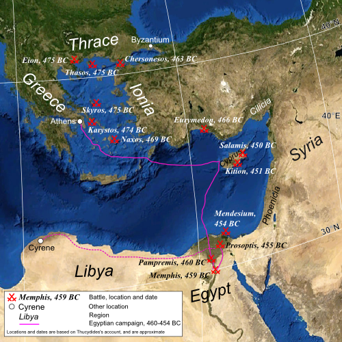
| விளக்கம் | Map of the eastern Mediterranean, showing the location of battles fought by the Delian League, 477–450 BC |
| நாள் | (UTC) |
| மூலம் | |
| ஆசிரியர் |
|
| ஒத்தக்கோப்பு | Derivative works of this file: Mapa de campanya de la Lliga de Delos.jpg |
| இது ஒரு திருத்தப்பட்ட படிமமாகும், அதாவது இதன் மூல வடிவத்திலிருந்து கணினி மூலம் இதில் மாற்றங்கள் செய்யப்பட்டுள்ளது. மூலக்கோப்பை இங்கு காணலாம்: Mediterranean Sea political map-blank.svg. திருத்தங்களைச் செய்தவர் MinisterForBadTimes.
|
| This image is in the public domain because it is a screenshot from NASA’s globe software World Wind using a public domain layer, such as Blue Marble, MODIS, Landsat, SRTM, USGS or GLOBE.
|
 |
| This work was previously under Public Domain, or a Free License. It has been digitally enhanced and/or modified. This derivative work has been (or is hereby) released into the public domain by its author, [[:{{{1}}}:User:{{{3}}}|{{{3}}}]] at the [[:{{{1}}}:|{{{2}}}]] project. This applies worldwide. In some countries this is not legally possible; if so:
|
Original upload log
This image is a derivative work of the following images:
- File:Mediterranean_Sea_political_map-blank.svg licensed with PD-WorldWind, PD-retouched-user-w
- 2008-05-19T16:14:51Z Sting 2046x1496 (1109412 Bytes) "Tropic of Cancer" label correction
- 2007-06-21T01:07:02Z Sting 2046x1496 (1109639 Bytes) {{Information |Description=Blank map of the [[:en:Mediterranean Sea|Mediterranean Sea]], with the State borders. |Source=Own work ;Background map : screenshot from NASA World Wind (Public Domain) |Date=June 2007 |Author=Eric
Uploaded with derivativeFX
கோப்பின் வரலாறு
குறித்த நேரத்தில் இருந்த படிமத்தைப் பார்க்க அந்நேரத்தின் மீது சொடுக்கவும்.
| நாள்/நேரம் | நகம் அளவு சிறுபடம் | அளவுகள் | பயனர் | கருத்து | |
|---|---|---|---|---|---|
| தற்போதைய | 20:39, 22 சூலை 2009 | | 500 × 500 (526 KB) | MinisterForBadTimes | Some rearrangements |
| 20:30, 22 சூலை 2009 |  | 500 × 500 (525 KB) | MinisterForBadTimes | Re-sized and shaped | |
| 06:56, 29 சூன் 2009 |  | 1,000 × 731 (1.27 MB) | MinisterForBadTimes | {{Information |Description=Map of the eastern Mediterranean, showing the location of battles fought by the Delian League, 477–450 BC |Source=*File:Mediterranean_Sea_political_map-blank.svg |Date=2009-06-29 07:51 (UTC) |Author=*[[:File:Mediterr |
கோப்பு பயன்பாடு
பின்வரும் பக்க இணைப்புகள் இப் படிமத்துக்கு இணைக்கபட்டுள்ளது(ளன):
கோப்பின் முழுமையான பயன்பாடு
கீழ்கண்ட மற்ற விக்கிகள் இந்த கோப்பை பயன்படுத்துகின்றன:
- af.wikipedia.org-திட்டத்தில் இதன் பயன்பாடு
- azb.wikipedia.org-திட்டத்தில் இதன் பயன்பாடு
- ca.wikipedia.org-திட்டத்தில் இதன் பயன்பாடு
- el.wikipedia.org-திட்டத்தில் இதன் பயன்பாடு
- en.wikipedia.org-திட்டத்தில் இதன் பயன்பாடு
- es.wikipedia.org-திட்டத்தில் இதன் பயன்பாடு
- eu.wikipedia.org-திட்டத்தில் இதன் பயன்பாடு
- fa.wikipedia.org-திட்டத்தில் இதன் பயன்பாடு
- hr.wikipedia.org-திட்டத்தில் இதன் பயன்பாடு
- hu.wikipedia.org-திட்டத்தில் இதன் பயன்பாடு
- id.wikipedia.org-திட்டத்தில் இதன் பயன்பாடு
- it.wikipedia.org-திட்டத்தில் இதன் பயன்பாடு
- it.wikiversity.org-திட்டத்தில் இதன் பயன்பாடு
- pl.wikipedia.org-திட்டத்தில் இதன் பயன்பாடு
- pnb.wikipedia.org-திட்டத்தில் இதன் பயன்பாடு
- pt.wikipedia.org-திட்டத்தில் இதன் பயன்பாடு
- ru.wikipedia.org-திட்டத்தில் இதன் பயன்பாடு
- sh.wikipedia.org-திட்டத்தில் இதன் பயன்பாடு
- ur.wikipedia.org-திட்டத்தில் இதன் பயன்பாடு