
படிமம்:Daedelus comparison, remote sensing in precision farming.jpg
இந்த முன்னோட்டத்தின் அளவு: 366 × 598 படப்புள்ளிகள் . மற்ற பிரிதிறன்கள்: 147 × 240 படப்புள்ளிகள் | 540 × 883 படப்புள்ளிகள் .
மூலக்கோப்பு (540 × 883 படவணுக்கள், கோப்பின் அளவு: 143 KB, MIME வகை: image/jpeg)
| இது விக்கிமீடியா பொதுக்கோப்பகத்தில் இருக்கும் ஒரு கோப்பாகும். இக்கோப்பைக் குறித்து அங்கே காணப்படும் படிம விளக்கப் பக்கத்தை இங்கே கீழே காணலாம்.
|
| விளக்கம் |
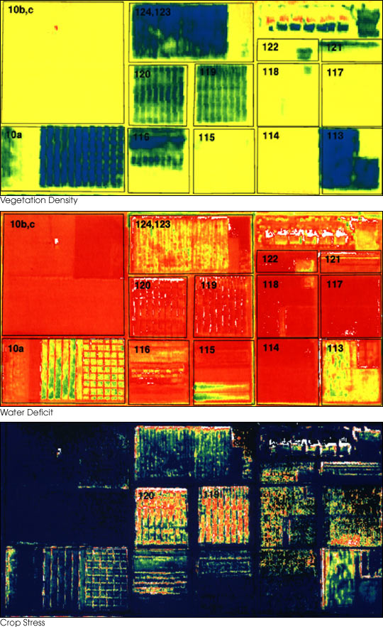
English: These three false-color images demonstrate some of the applications of remote sensing in precision farming. The goal of precision farming is to improve farmers’ profits and harvest yields while reducing the negative impacts of farming on the environment that come from over-application of chemicals. The images were acquired by the Daedalus sensor aboard a NASA aircraft flying over the Maricopa Agricultural Center in Arizona.
|
|||||
| நாள் | before 30 சனவரி 2001 | |||||
| மூலம் | earthobservatory.nasa.gov (NASA Earth Observatory, Image of the Day 2001-01-30 "Precision Farming") | |||||
| ஆசிரியர் | Susan Moran, Landsat 7 Science Team and USDA Agricultural Research Service (U.S. Government work) | |||||
| அனுமதி (இக்கோப்பை மீண்டும் பயன்படுத்துதல்) |
|
|||||
| ஒத்தக்கோப்பு |
.jpg) |

கோப்பின் வரலாறு
குறித்த நேரத்தில் இருந்த படிமத்தைப் பார்க்க அந்நேரத்தின் மீது சொடுக்கவும்.
| நாள்/நேரம் | நகம் அளவு சிறுபடம் | அளவுகள் | பயனர் | கருத்து | |
|---|---|---|---|---|---|
| தற்போதைய | 01:10, 28 சூன் 2010 | | 540 × 883 (143 KB) | Bdk | {{Information |Description={{en|These three false-color images demonstrate some of the applications of remote sensing in precision farming. The goal of precision farming is to improve farmers’ profits and harvest yields whi |
கோப்பு பயன்பாடு
பின்வரும் பக்க இணைப்புகள் இப் படிமத்துக்கு இணைக்கபட்டுள்ளது(ளன):
கோப்பின் முழுமையான பயன்பாடு
கீழ்கண்ட மற்ற விக்கிகள் இந்த கோப்பை பயன்படுத்துகின்றன:
- ar.wikipedia.org-திட்டத்தில் இதன் பயன்பாடு
- en.wikipedia.org-திட்டத்தில் இதன் பயன்பாடு
- en.wikiversity.org-திட்டத்தில் இதன் பயன்பாடு
- eu.wikipedia.org-திட்டத்தில் இதன் பயன்பாடு
- fr.wikipedia.org-திட்டத்தில் இதன் பயன்பாடு
- id.wikipedia.org-திட்டத்தில் இதன் பயன்பாடு
- it.wikipedia.org-திட்டத்தில் இதன் பயன்பாடு
- ja.wikipedia.org-திட்டத்தில் இதன் பயன்பாடு
- ko.wikipedia.org-திட்டத்தில் இதன் பயன்பாடு
- ms.wikipedia.org-திட்டத்தில் இதன் பயன்பாடு
- oc.wikipedia.org-திட்டத்தில் இதன் பயன்பாடு
- ru.wikipedia.org-திட்டத்தில் இதன் பயன்பாடு
- tr.wikipedia.org-திட்டத்தில் இதன் பயன்பாடு
- uk.wikipedia.org-திட்டத்தில் இதன் பயன்பாடு
- www.wikidata.org-திட்டத்தில் இதன் பயன்பாடு