
படிமம்:CPLPmap2.png
இந்த முன்னோட்டத்தின் அளவு: 800 × 338 படப்புள்ளிகள் . மற்ற பிரிதிறன்கள்: 320 × 135 படப்புள்ளிகள் | 640 × 270 படப்புள்ளிகள் | 1,480 × 625 படப்புள்ளிகள் .
மூலக்கோப்பு (1,480 × 625 படவணுக்கள், கோப்பின் அளவு: 72 KB, MIME வகை: image/png)
| இது விக்கிமீடியா பொதுக்கோப்பகத்தில் இருக்கும் ஒரு கோப்பாகும். இக்கோப்பைக் குறித்து அங்கே காணப்படும் படிம விளக்கப் பக்கத்தை இங்கே கீழே காணலாம்.
|

|
This organization map image could be re-created using vector graphics as an SVG file. This has several advantages; see Commons:Media for cleanup for more information. If an SVG form of this image is available, please upload it and afterwards replace this template with
{{vector version available|new image name}}.
It is recommended to name the SVG file “CPLPmap2.svg”—then the template Vector version available (or Vva) does not need the new image name parameter. |
| விளக்கம் |
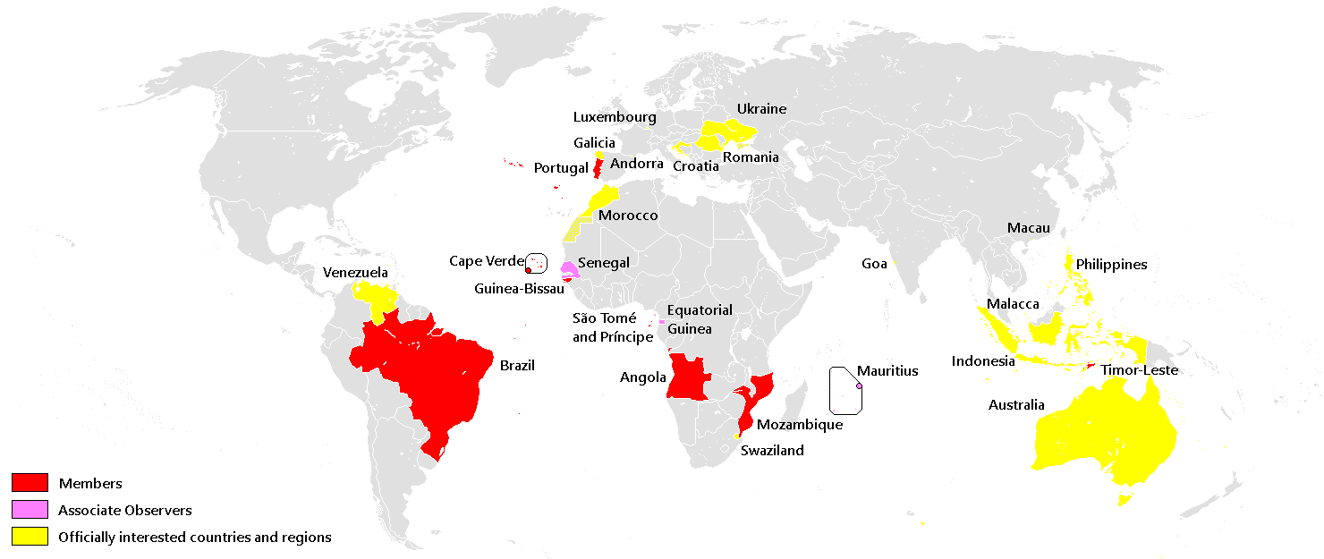
English: Edited map from Ceha, updated officially interested countries and regions as of 24/08/2010 |
| நாள் | (UTC) |
| மூலம் | |
| ஆசிரியர் |
|
| இது ஒரு திருத்தப்பட்ட படிமமாகும், அதாவது இதன் மூல வடிவத்திலிருந்து கணினி மூலம் இதில் மாற்றங்கள் செய்யப்பட்டுள்ளது. திருத்தங்கள்: updated "officially interested countries and regions". மூலக்கோப்பை இங்கு காணலாம்: CPLPmap1.png. திருத்தங்களைச் செய்தவர் Jonaspv.
|
இந்த ஆக்கத்தின் காப்புரிமையாளரான நான் இதனைப் பின்வரும் உரிமத்தின் கீழ் வெளியிடுகின்றேன்:
| இந்த கோப்பு Creative Commons Attribution-Share Alike 3.0 Unported உரிமத்தின் கீழ் உள்ளது. | ||
| ||
| This licensing tag was added to this file as part of the GFDL licensing update. |

|
GNU Free Documentation License விதிமுறைகளின் கீழ் இந்த ஆவணத்தை நகலெடுக்க, விநியோகிக்க மற்றும்/அல்லது மாற்றுவதற்கு அனுமதி வழங்கப்பட்டுள்ளது, Free Software Foundation;ஆல் வெளியிடப்பட்ட பதிப்பு 1.2 அல்லது அதற்குப் பிந்தைய பதிப்பு, மாற்றமில்லாத பிரிவுகள், முன் அட்டை உரைகள் மற்றும் பின் அட்டை உரைகள் இல்லாமல் வெளியிடப்பட்டது. GNU Free Documentation License என்ற தலைப்பில் உரிமத்தின் நகல் சேர்க்கப்பட்டுள்ளது. |
நீர் உமக்கு விருப்பமான உரிமத்தை தேர்ந்தெடுக்கலாம்.
Original upload log
This image is a derivative work of the following images:
- File:CPLPmap1.png licensed with Cc-by-sa-3.0-migrated, GFDL
- 2009-02-10T09:59:21Z Ceha 1357x628 (51057 Bytes) {{Information |Description={{en|1=Edited map from Felipe Fontoura, added Officially interested countries and regions }} {{hr|1=Uredio zemljovid od Felpe Fontoure, dodao službeno zainteresirane zemlje i regije}} |Source=http:
Uploaded with derivativeFX
கோப்பின் வரலாறு
குறித்த நேரத்தில் இருந்த படிமத்தைப் பார்க்க அந்நேரத்தின் மீது சொடுக்கவும்.
| நாள்/நேரம் | நகம் அளவு சிறுபடம் | அளவுகள் | பயனர் | கருத்து | |
|---|---|---|---|---|---|
| தற்போதைய | 10:51, 30 சூலை 2014 | | 1,480 × 625 (72 KB) | Nicolay Sidorov | Western Sahara and Crimea are disputed |
| 02:52, 23 செப்டெம்பர் 2013 |  | 1,480 × 625 (55 KB) | Spesh531 | easily editable, and added venezuela, changed rio de oro to sahrawi (rio de oro is not a termed used today) | |
| 02:06, 3 மே 2013 |  | 800 × 370 (118 KB) | GeoMauri | +correction | |
| 02:02, 3 மே 2013 |  | 800 × 370 (118 KB) | GeoMauri | +correction | |
| 16:17, 24 சூலை 2010 |  | 1,357 × 628 (51 KB) | Jonaspv | {{Information |Description={{en|1=Edited map from Ceha, updated officially interested countries and regions as of 24/08/2010}} |Source=*File:CPLPmap1.png |Date=2010-07-24 16:15 (UTC) |Author=*File:CPLPmap1.png: Ceha *derivative work: ~~~ |Perm |
கோப்பு பயன்பாடு
பின்வரும் பக்க இணைப்புகள் இப் படிமத்துக்கு இணைக்கபட்டுள்ளது(ளன):
கோப்பின் முழுமையான பயன்பாடு
கீழ்கண்ட மற்ற விக்கிகள் இந்த கோப்பை பயன்படுத்துகின்றன:
- fa.wikipedia.org-திட்டத்தில் இதன் பயன்பாடு
- hu.wikipedia.org-திட்டத்தில் இதன் பயன்பாடு
- kn.wikipedia.org-திட்டத்தில் இதன் பயன்பாடு
- mzn.wikipedia.org-திட்டத்தில் இதன் பயன்பாடு
- nl.wikipedia.org-திட்டத்தில் இதன் பயன்பாடு
- pl.wikipedia.org-திட்டத்தில் இதன் பயன்பாடு
- sw.wikipedia.org-திட்டத்தில் இதன் பயன்பாடு