
படிமம்:Satellite image of Bangladesh in October 2001.jpg

இந்த முன்னோட்டத்தின் அளவு: 554 × 599 படப்புள்ளிகள் . மற்ற பிரிதிறன்கள்: 222 × 240 படப்புள்ளிகள் | 444 × 480 படப்புள்ளிகள் | 710 × 768 படப்புள்ளிகள் | 947 × 1,024 படப்புள்ளிகள் | 2,214 × 2,394 படப்புள்ளிகள் .
மூலக்கோப்பு (2,214 × 2,394 படவணுக்கள், கோப்பின் அளவு: 674 KB, MIME வகை: image/jpeg)
| இது விக்கிமீடியா பொதுக்கோப்பகத்தில் இருக்கும் ஒரு கோப்பாகும். இக்கோப்பைக் குறித்து அங்கே காணப்படும் படிம விளக்கப் பக்கத்தை இங்கே கீழே காணலாம்.
|
| விளக்கம் |
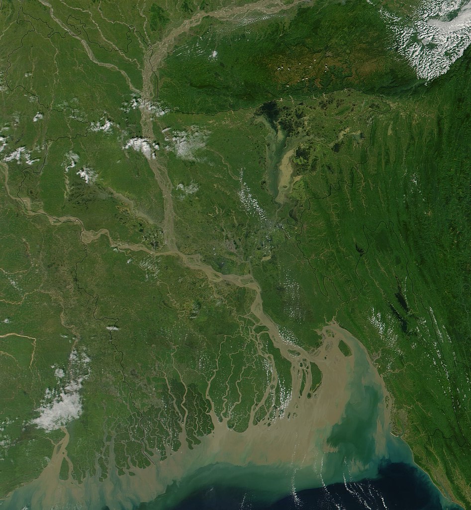
Satellite image of Bangladesh in October 2001 True-color MODIS image from October 23, 2001. Lush with vegetation to the south, numerous rivers, brown with churned up sediment, flow into the valley of the Brahmaputra River in Assam, India. The Brahmaputra turns southward at the border of Bangladesh and is soon joined by the Ganges River, flowing in from image left. The mighty river splits into numerous channels as it runs out toward the Bay of Bengal, giving the region the name "Mouths of the Ganges." Vast amounts of sediment are being emptied into the Bay by the river, and greenish blue swirls could be a mixture of sediment and phytoplankton. |
| நாள் | |
| மூலம் | Cropped from Visible Earth |
| ஆசிரியர் | Jacques Descloitres, MODIS Land Rapid Response Team, NASA/GSFC |
| This file is in the public domain in the United States because it was solely created by NASA. NASA copyright policy states that "NASA material is not protected by copyright unless noted". (See Template:PD-USGov, NASA copyright policy page or JPL Image Use Policy.) | ||
 |
Warnings:
|
கோப்பின் வரலாறு
குறித்த நேரத்தில் இருந்த படிமத்தைப் பார்க்க அந்நேரத்தின் மீது சொடுக்கவும்.
| நாள்/நேரம் | நகம் அளவு சிறுபடம் | அளவுகள் | பயனர் | கருத்து | |
|---|---|---|---|---|---|
| தற்போதைய | 15:38, 18 திசம்பர் 2004 | | 2,214 × 2,394 (674 KB) | Hautala | {{PD-USGov-NASA}} Satellite image of Bangladesh in October 2001. Original image taken from NASA's Visible Earth http://visibleearth.nasa.gov/cgi-bin/viewrecord?10722 |
கோப்பு பயன்பாடு
பின்வரும் பக்க இணைப்புகள் இப் படிமத்துக்கு இணைக்கபட்டுள்ளது(ளன):
கோப்பின் முழுமையான பயன்பாடு
கீழ்கண்ட மற்ற விக்கிகள் இந்த கோப்பை பயன்படுத்துகின்றன:
- af.wikipedia.org-திட்டத்தில் இதன் பயன்பாடு
- ar.wikipedia.org-திட்டத்தில் இதன் பயன்பாடு
- ast.wikipedia.org-திட்டத்தில் இதன் பயன்பாடு
- as.wikipedia.org-திட்டத்தில் இதன் பயன்பாடு
- ba.wikipedia.org-திட்டத்தில் இதன் பயன்பாடு
- be-tarask.wikipedia.org-திட்டத்தில் இதன் பயன்பாடு
- bg.wikipedia.org-திட்டத்தில் இதன் பயன்பாடு
- bm.wikipedia.org-திட்டத்தில் இதன் பயன்பாடு
- bn.wikipedia.org-திட்டத்தில் இதன் பயன்பாடு
- bs.wikipedia.org-திட்டத்தில் இதன் பயன்பாடு
- ca.wikipedia.org-திட்டத்தில் இதன் பயன்பாடு
- cs.wikipedia.org-திட்டத்தில் இதன் பயன்பாடு
- de.wikipedia.org-திட்டத்தில் இதன் பயன்பாடு
- en.wikipedia.org-திட்டத்தில் இதன் பயன்பாடு
- en.wikiquote.org-திட்டத்தில் இதன் பயன்பாடு
- es.wikipedia.org-திட்டத்தில் இதன் பயன்பாடு
- fi.wikipedia.org-திட்டத்தில் இதன் பயன்பாடு
- frr.wikipedia.org-திட்டத்தில் இதன் பயன்பாடு
- id.wikipedia.org-திட்டத்தில் இதன் பயன்பாடு
- it.wikipedia.org-திட்டத்தில் இதன் பயன்பாடு
- jv.wikipedia.org-திட்டத்தில் இதன் பயன்பாடு
- lt.wikipedia.org-திட்டத்தில் இதன் பயன்பாடு
- new.wikipedia.org-திட்டத்தில் இதன் பயன்பாடு
- nl.wikipedia.org-திட்டத்தில் இதன் பயன்பாடு
- no.wikipedia.org-திட்டத்தில் இதன் பயன்பாடு
- pl.wikipedia.org-திட்டத்தில் இதன் பயன்பாடு
- pt.wikipedia.org-திட்டத்தில் இதன் பயன்பாடு
- roa-tara.wikipedia.org-திட்டத்தில் இதன் பயன்பாடு
- ru.wikipedia.org-திட்டத்தில் இதன் பயன்பாடு
- sh.wikipedia.org-திட்டத்தில் இதன் பயன்பாடு
- sr.wikipedia.org-திட்டத்தில் இதன் பயன்பாடு
- te.wikipedia.org-திட்டத்தில் இதன் பயன்பாடு
- tg.wikipedia.org-திட்டத்தில் இதன் பயன்பாடு
- th.wikipedia.org-திட்டத்தில் இதன் பயன்பாடு
- uk.wikipedia.org-திட்டத்தில் இதன் பயன்பாடு
சிறப்பு பக்கம்-மொத்த பயன்பாடு - இதன் மூலம் இந்த கோப்பின் மொத்த பயன்பாட்டை அறிய முடியும்