
படிமம்:New York Harbor Waterfront 1727 panorama map.jpg

இந்த முன்னோட்டத்தின் அளவு: 800 × 390 படப்புள்ளிகள் . மற்ற பிரிதிறன்கள்: 320 × 156 படப்புள்ளிகள் | 640 × 312 படப்புள்ளிகள் | 1,024 × 499 படப்புள்ளிகள் | 1,280 × 623 படப்புள்ளிகள் | 2,560 × 1,247 படப்புள்ளிகள் | 5,600 × 2,727 படப்புள்ளிகள் .
மூலக்கோப்பு (5,600 × 2,727 படவணுக்கள், கோப்பின் அளவு: 4.76 MB, MIME வகை: image/jpeg)
| இது விக்கிமீடியா பொதுக்கோப்பகத்தில் இருக்கும் ஒரு கோப்பாகும். இக்கோப்பைக் குறித்து அங்கே காணப்படும் படிம விளக்கப் பக்கத்தை இங்கே கீழே காணலாம்.
|
சுருக்கம்
| விளக்கம் |
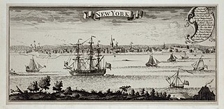
English: A panoramic view of the New York Harbor waterfront seen from Long Island in 1727. This is an inset from A Map of the British Empire in America with the French and Spanish Settlements adjacent thereto, by Henry Popple. It was originally engraved by Willm. Henry Toms (who also signed it) & R.W. Seale, issued in 1733.[1]
|
||
| நாள் | |||
| மூலம் |
|
||
| ஆசிரியர் | It was originally engraved by Willm. Henry Toms & R.W. Seale, issued in 1733. The view date is 1727. |
அனுமதி
|
This work is in the public domain in its country of origin and other countries and areas where the copyright term is the author's life plus 100 years or fewer. | |
| This file has been identified as being free of known restrictions under copyright law, including all related and neighboring rights. | |
- ↑ New York City Waterfront - 1727. Geographic Guide. Archived from the original on January 22, 2024. Retrieved on January 22, 2024.
கோப்பின் வரலாறு
குறித்த நேரத்தில் இருந்த படிமத்தைப் பார்க்க அந்நேரத்தின் மீது சொடுக்கவும்.
| நாள்/நேரம் | நகம் அளவு சிறுபடம் | அளவுகள் | பயனர் | கருத்து | |
|---|---|---|---|---|---|
| தற்போதைய | 18:47, 22 சனவரி 2024 | | 5,600 × 2,727 (4.76 MB) | Artanisen | Uploaded a work by It was originally engraved by Willm. Henry Toms & R.W. Seale, issued in 1733. from The New York Public Library - https://digitalcollections.nypl.org/items/510d47da-f334-a3d9-e040-e00a18064a99 with UploadWizard |
கோப்பு பயன்பாடு
பின்வரும் பக்க இணைப்புகள் இப் படிமத்துக்கு இணைக்கபட்டுள்ளது(ளன):
கோப்பின் முழுமையான பயன்பாடு
கீழ்கண்ட மற்ற விக்கிகள் இந்த கோப்பை பயன்படுத்துகின்றன:
- en.wikipedia.org-திட்டத்தில் இதன் பயன்பாடு
- es.wikipedia.org-திட்டத்தில் இதன் பயன்பாடு
- id.wikipedia.org-திட்டத்தில் இதன் பயன்பாடு
- it.wikipedia.org-திட்டத்தில் இதன் பயன்பாடு
- ko.wikipedia.org-திட்டத்தில் இதன் பயன்பாடு