
படிமம்:MongolEmpireDivisions1300.png
இந்த முன்னோட்டத்தின் அளவு: 800 × 467 படப்புள்ளிகள் . மற்ற பிரிதிறன்கள்: 320 × 187 படப்புள்ளிகள் | 640 × 373 படப்புள்ளிகள் | 1,024 × 597 படப்புள்ளிகள் | 1,644 × 959 படப்புள்ளிகள் .
மூலக்கோப்பு (1,644 × 959 படவணுக்கள், கோப்பின் அளவு: 37 KB, MIME வகை: image/png)
| இது விக்கிமீடியா பொதுக்கோப்பகத்தில் இருக்கும் ஒரு கோப்பாகும். இக்கோப்பைக் குறித்து அங்கே காணப்படும் படிம விளக்கப் பக்கத்தை இங்கே கீழே காணலாம்.
|
சுருக்கம்
| விளக்கம் |
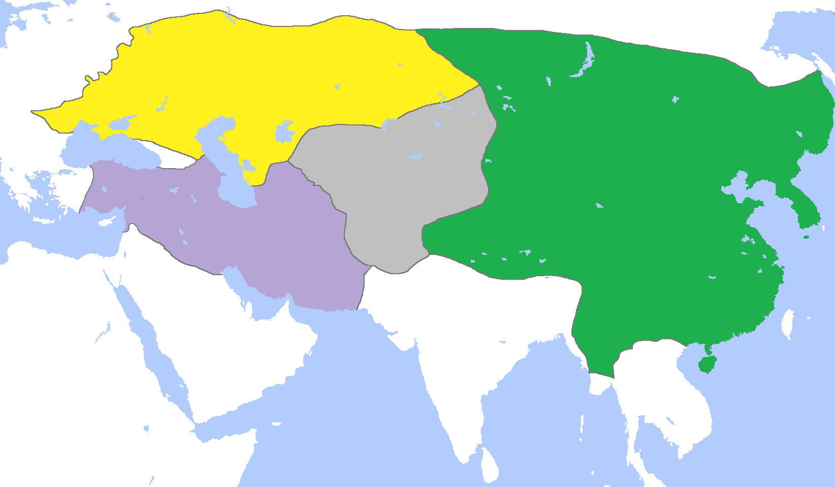
English: Map of the Mongol Empire c. 1300, after its four subdivisions into the:
Français : Carte des Divisions de l'Empire mongol vers 1300 :
|
| நாள் | |
| மூலம் | சொந்த முயற்சி |
| ஆசிரியர் | Gabagool |
அனுமதி
இந்த ஆக்கத்தின் காப்புரிமையாளரான நான் இதனைப் பின்வரும் உரிமத்தின் கீழ் வெளியிடுகின்றேன்:
This file is licensed under the Creative Commons Attribution 3.0 Unported license.
- நீங்கள் சுதந்திரமாக:
- பகிர்ந்து கொள்ள – வேலையை நகலெடுக்க, விநியோகிக்க மற்றும் அனுப்ப
- மீண்டும் கலக்க – வேலைக்கு பழகிக்கொள்ள.
- கீழ்க்காணும் விதிகளுக்கு ஏற்ப,
- பண்புக்கூறுகள் – நீங்கள் பொருத்தமான உரிமையை வழங்க வேண்டும், உரிமத்திற்கான இணைப்பை வழங்க வேண்டும் மற்றும் மாற்றங்கள் செய்யப்பட்டிருந்தால் குறிப்பிட வேண்டும். நீங்கள் ஏற்புடைய எந்த முறையிலும் அவ்வாறு செய்யலாம், ஆனால் எந்த வகையிலும் உரிமதாரர் உங்களை அல்லது உங்கள் பயன்பாட்டிற்கு ஒப்புதல் அளிக்கும் படி பரிந்துரைக்க கூடாது.
கோப்பின் வரலாறு
குறித்த நேரத்தில் இருந்த படிமத்தைப் பார்க்க அந்நேரத்தின் மீது சொடுக்கவும்.
| நாள்/நேரம் | நகம் அளவு சிறுபடம் | அளவுகள் | பயனர் | கருத்து | |
|---|---|---|---|---|---|
| தற்போதைய | 15:40, 26 ஆகத்து 2023 | | 1,644 × 959 (37 KB) | Ecthelion83 | Tsushima was never under Mongol control and was never a vassal state to the Mongols |
| 15:59, 16 நவம்பர் 2022 |  | 1,644 × 959 (48 KB) | Gyalu22 | Reverted to version as of 01:33, 29 July 2015 (UTC) | |
| 12:02, 4 சூன் 2018 |  | 1,644 × 959 (29 KB) | Julieta39 | No Golden Horde rule on the Theodoro principality (South Crimea) | |
| 11:35, 4 சூன் 2018 |  | 1,644 × 959 (29 KB) | Julieta39 | Shorelines, no modern dam lakes, Galicia and Hungary out of the Golden Horde rule, Trebizond Empire out of the Ilkhans rule. | |
| 01:33, 29 சூலை 2015 |  | 1,644 × 959 (48 KB) | History of Persia | The ilkhans controlled anatolia | |
| 01:44, 5 ஆகத்து 2014 |  | 1,644 × 959 (61 KB) | Tm | Reverted to version as of 11:52, 6 June 2013 reverting persistent vandalism. As you were told before upload your version under a new filename | |
| 00:51, 5 ஆகத்து 2014 |  | 1,644 × 959 (38 KB) | Flamarial~commonswiki | As vassal states are not included in territories due to widespread cartographic convention, reverted to an earlier version to account for this. The Kingdom of Goryeo was instead a compulsory ally and vassal state of the Mongol Empire, not directly anne... | |
| 00:47, 5 ஆகத்து 2014 |  | 1,644 × 959 (61 KB) | Tm | Reverted to version as of 11:52, 6 June 2013 | |
| 16:49, 4 ஆகத்து 2014 |  | 1,644 × 959 (38 KB) | Flamarial~commonswiki | As vassal states are not included in territories due to widespread cartographic convention, reverted to an earlier version to account for this. The Kingdom of Goryeo was a compulsory ally and vassal state of the Mongol Empire, but it was not directly a... | |
| 11:52, 6 சூன் 2013 |  | 1,644 × 959 (61 KB) | Tm | Reverted to version as of 18:40, 5 June 2013 Please read : http://commons.wikimedia.org/w/index.php?title=Commons:Village_pump&diff=33196237&oldid=33196194 and https://secure.wikimedia.org/wikipedia/commons/wiki/Commons:Village_pump#Edit_warring_ove |
கோப்பு பயன்பாடு
பின்வரும் 4 பக்கங்கள் இணைப்பு இப் படிமத்துக்கு இணைக்கபட்டுள்ளது(ளன):
கோப்பின் முழுமையான பயன்பாடு
கீழ்கண்ட மற்ற விக்கிகள் இந்த கோப்பை பயன்படுத்துகின்றன:
- af.wikipedia.org-திட்டத்தில் இதன் பயன்பாடு
- ar.wikipedia.org-திட்டத்தில் இதன் பயன்பாடு
- ast.wikipedia.org-திட்டத்தில் இதன் பயன்பாடு
- azb.wikipedia.org-திட்டத்தில் இதன் பயன்பாடு
- be-tarask.wikipedia.org-திட்டத்தில் இதன் பயன்பாடு
- bn.wikipedia.org-திட்டத்தில் இதன் பயன்பாடு
- ckb.wikipedia.org-திட்டத்தில் இதன் பயன்பாடு
- en.wikipedia.org-திட்டத்தில் இதன் பயன்பாடு
- Golden Horde
- Cumans
- Chagatai Khanate
- Jayaatu Khan Tugh Temür
- Külüg Khan
- Borjigin
- Duwa
- Toqta
- History of Xinjiang
- History of Mongolia
- Yuan dynasty in Inner Asia
- Kaidu–Kublai war
- Esen Buqa–Ayurbarwada war
- History of the western steppe
- History of the central steppe
- User:Falcaorib
- Template:Mongol Empire in 1300
- en.wikivoyage.org-திட்டத்தில் இதன் பயன்பாடு
- eo.wikipedia.org-திட்டத்தில் இதன் பயன்பாடு
- es.wikipedia.org-திட்டத்தில் இதன் பயன்பாடு
- et.wikipedia.org-திட்டத்தில் இதன் பயன்பாடு
- eu.wikipedia.org-திட்டத்தில் இதன் பயன்பாடு
- fa.wikipedia.org-திட்டத்தில் இதன் பயன்பாடு
- fr.wikipedia.org-திட்டத்தில் இதன் பயன்பாடு
- id.wikipedia.org-திட்டத்தில் இதன் பயன்பாடு
சிறப்பு பக்கம்-மொத்த பயன்பாடு - இதன் மூலம் இந்த கோப்பின் மொத்த பயன்பாட்டை அறிய முடியும்