
படிமம்:Celtic Sea and Bay of Biscay bathymetric map-fr.svg

Size of this PNG preview of this SVG file: 548 × 599 படப்புள்ளிகள். மற்ற பிரிதிறன்கள்: 219 × 240 படப்புள்ளிகள் | 439 × 480 படப்புள்ளிகள் | 702 × 768 படப்புள்ளிகள் | 936 × 1,024 படப்புள்ளிகள் | 1,872 × 2,048 படப்புள்ளிகள் | 3,478 × 3,804 படப்புள்ளிகள் .
மூலக்கோப்பு (SVG கோப்பு, பெயரளவில் 3,478 × 3,804 பிக்சல்கள், கோப்பு அளவு: 4.93 MB)
| இது விக்கிமீடியா பொதுக்கோப்பகத்தில் இருக்கும் ஒரு கோப்பாகும். இக்கோப்பைக் குறித்து அங்கே காணப்படும் படிம விளக்கப் பக்கத்தை இங்கே கீழே காணலாம்.
|
சுருக்கம்
| விளக்கம் |
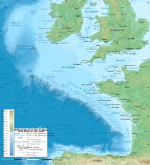
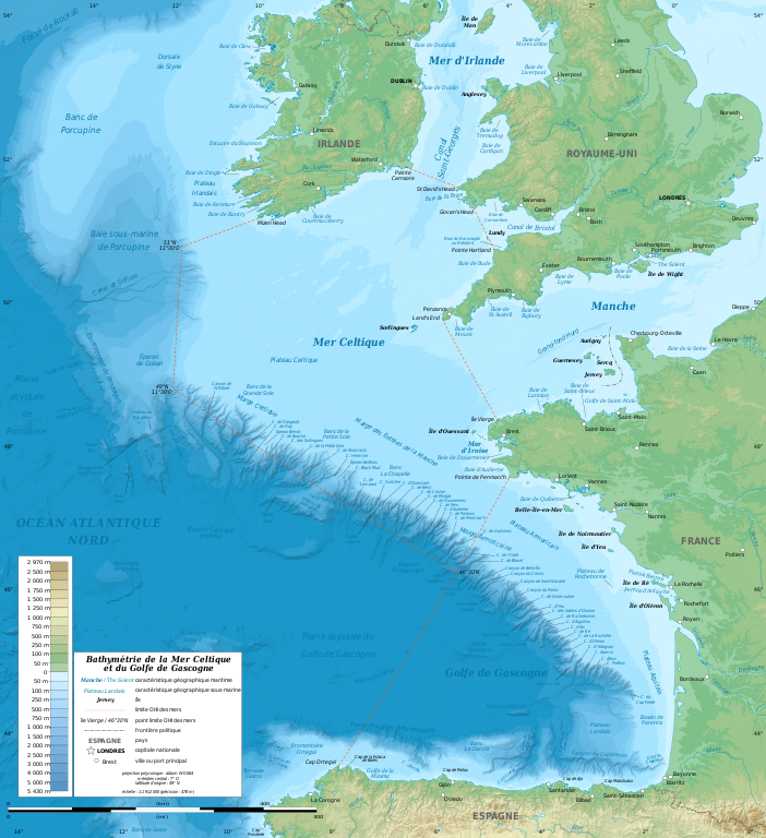
English: Bathymetric map in French of the Celtic Sea and the Bay of Biscay. Limits of the seas as specified by the International Hydrographic Organization.
Note: the background map is a raster image embedded in the SVG file. Français : Carte bathymétrique en français de la Mer Celtique et du Golfe de Gascogne. Limites des mers telles que définies par l'Organisation Hydrographique Internationale. Note : le fond de carte est une image bitmap embarquée dans le fichier SVG.
|
||
| நாள் | சனவரி 2011, upgraded 2019-10 | ||
| மூலம் |
சொந்த முயற்சி
|
||
| ஆசிரியர் | Eric Gaba (Sting - fr:Sting) | ||
| அனுமதி (இக்கோப்பை மீண்டும் பயன்படுத்துதல்) |
|
||
| ஒத்தக்கோப்பு |
[]
|
||
| SVG genesis |


| Camera location | | View this and other nearby images on: OpenStreetMap |
|---|
அனுமதி
இந்த ஆக்கத்தின் காப்புரிமையாளரான Eric Gaba (Wikimedia Commons user Sting) எனும் நான் இதனைப் பின்வரும் உரிமத்தின் கீழ் வெளியிடுகின்றேன்:
இந்த கோப்பு Creative Commons Attribution-Share Alike 3.0 Unported உரிமத்தின் கீழ் உள்ளது.
பண்புக்கூறுகள்: Eric Gaba (Wikimedia Commons user Sting)
- நீங்கள் சுதந்திரமாக:
- பகிர்ந்து கொள்ள – வேலையை நகலெடுக்க, விநியோகிக்க மற்றும் அனுப்ப
- மீண்டும் கலக்க – வேலைக்கு பழகிக்கொள்ள.
- கீழ்க்காணும் விதிகளுக்கு ஏற்ப,
- பண்புக்கூறுகள் – நீங்கள் பொருத்தமான உரிமையை வழங்க வேண்டும், உரிமத்திற்கான இணைப்பை வழங்க வேண்டும் மற்றும் மாற்றங்கள் செய்யப்பட்டிருந்தால் குறிப்பிட வேண்டும். நீங்கள் ஏற்புடைய எந்த முறையிலும் அவ்வாறு செய்யலாம், ஆனால் எந்த வகையிலும் உரிமதாரர் உங்களை அல்லது உங்கள் பயன்பாட்டிற்கு ஒப்புதல் அளிக்கும் படி பரிந்துரைக்க கூடாது.
- அதே மாதிரி பகிர் – நீங்கள் ரீமிக்ஸ் செய்தாலோ, உருமாற்றம் செய்தாலோ அல்லது பொருளை உருவாக்கினாலோ, உங்கள் பங்களிப்புகளை அல்லது இணக்கமான உரிமம் கீழ் அசலாக விநியோகிக்க வேண்டும்.
கோப்பின் வரலாறு
குறித்த நேரத்தில் இருந்த படிமத்தைப் பார்க்க அந்நேரத்தின் மீது சொடுக்கவும்.
| நாள்/நேரம் | நகம் அளவு சிறுபடம் | அளவுகள் | பயனர் | கருத்து | |
|---|---|---|---|---|---|
| தற்போதைய | 13:11, 4 நவம்பர் 2019 | | 3,478 × 3,804 (4.93 MB) | Sting | Correction of a name |
| 20:56, 28 அக்டோபர் 2019 |  | 3,478 × 3,804 (4.92 MB) | Sting | New map using GEBCO 15 Sec topographic data ; rivers from ECRINS ; added names | |
| 18:15, 24 சனவரி 2011 |  | 1,749 × 1,913 (613 KB) | Sting | A few more names | |
| 16:54, 23 சனவரி 2011 |  | 1,749 × 1,913 (610 KB) | Sting | Added maritim features names | |
| 03:26, 23 சனவரி 2011 |  | 1,749 × 1,913 (559 KB) | Sting | == {{int:filedesc}} == {{Information |Description={{en|Bathymetric map in French of the Celtic Sea and the Bay of Biscay.<br/> ''Note: the background map is a raster image embedded in the SVG file.''}} {{fr|Carte b |
கோப்பு பயன்பாடு
பின்வரும் பக்க இணைப்புகள் இப் படிமத்துக்கு இணைக்கபட்டுள்ளது(ளன):
கோப்பின் முழுமையான பயன்பாடு
கீழ்கண்ட மற்ற விக்கிகள் இந்த கோப்பை பயன்படுத்துகின்றன:
- ar.wikipedia.org-திட்டத்தில் இதன் பயன்பாடு
- bs.wikipedia.org-திட்டத்தில் இதன் பயன்பாடு
- cs.wikipedia.org-திட்டத்தில் இதன் பயன்பாடு
- de.wikipedia.org-திட்டத்தில் இதன் பயன்பாடு
- eo.wikipedia.org-திட்டத்தில் இதன் பயன்பாடு
- fr.wikipedia.org-திட்டத்தில் இதன் பயன்பாடு
- gv.wikipedia.org-திட்டத்தில் இதன் பயன்பாடு
- hr.wikipedia.org-திட்டத்தில் இதன் பயன்பாடு
- mr.wikipedia.org-திட்டத்தில் இதன் பயன்பாடு
- oc.wikipedia.org-திட்டத்தில் இதன் பயன்பாடு
- pl.wiktionary.org-திட்டத்தில் இதன் பயன்பாடு
- sh.wikipedia.org-திட்டத்தில் இதன் பயன்பாடு
- sr.wikipedia.org-திட்டத்தில் இதன் பயன்பாடு
- sv.wikipedia.org-திட்டத்தில் இதன் பயன்பாடு
- th.wikipedia.org-திட்டத்தில் இதன் பயன்பாடு
- ur.wikipedia.org-திட்டத்தில் இதன் பயன்பாடு
- www.wikidata.org-திட்டத்தில் இதன் பயன்பாடு