
படிமம்:AfricaMap2.jpg

இந்த முன்னோட்டத்தின் அளவு: 800 × 307 படப்புள்ளிகள் . மற்ற பிரிதிறன்கள்: 320 × 123 படப்புள்ளிகள் | 640 × 245 படப்புள்ளிகள் | 1,781 × 683 படப்புள்ளிகள் .
மூலக்கோப்பு (1,781 × 683 படவணுக்கள், கோப்பின் அளவு: 225 KB, MIME வகை: image/jpeg)
| இது விக்கிமீடியா பொதுக்கோப்பகத்தில் இருக்கும் ஒரு கோப்பாகும். இக்கோப்பைக் குறித்து அங்கே காணப்படும் படிம விளக்கப் பக்கத்தை இங்கே கீழே காணலாம்.
|
சுருக்கம்
| விளக்கம் |
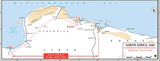
English: Axis movements are depicted in red, and Allied positions are denoted by blue lines. Key dates are shown in boxes. |
| நாள் | |
| மூலம் |
Archive link to original website used for the map and the archive link to the map source page. Current link to map, and link to map source page. |
| ஆசிரியர் | The History Department of the United States Military Academy |
| அனுமதி (இக்கோப்பை மீண்டும் பயன்படுத்துதல்) |
US Government document |


அனுமதி
This file is a work of a U.S. Army soldier or employee, taken or made as part of that person's official duties. As a work of the U.S. federal government, it is in the public domain in the United States.
|
 |
Original upload log
The original description page was here. All following user names refer to en.wikipedia.
- 2004-08-20 12:42 GeneralPatton 1202×446×8 (107723 bytes) Rommel's first offensive -- [[March 24]], [[1941]] - [[June 15]], [[1941]]
கோப்பின் வரலாறு
குறித்த நேரத்தில் இருந்த படிமத்தைப் பார்க்க அந்நேரத்தின் மீது சொடுக்கவும்.
| நாள்/நேரம் | நகம் அளவு சிறுபடம் | அளவுகள் | பயனர் | கருத்து | |
|---|---|---|---|---|---|
| தற்போதைய | 01:31, 2 ஏப்பிரல் 2021 | 1,781 × 683 (225 KB) | EnigmaMcmxc | hi rez version and meta data fix | |
| 15:04, 8 சனவரி 2021 | 951 × 364 (93 KB) | EnigmaMcmxc | Updated version of the map from the sourced website | ||
| 21:04, 29 ஆகத்து 2010 | 1,202 × 446 (119 KB) | Hohum | Cleaned | ||
| 19:16, 28 ஏப்பிரல் 2007 | 1,202 × 446 (105 KB) | Kameraad Pjotr | {{Information |Description=Rommel's first offensive <br/>US ARMY <br/>License: US Government document. Printed by the Government printing office. |Source=Originally from [http://en.wikipedia.org en.wikipedia]; description page is/was [http://en.wikipedi |
கோப்பு பயன்பாடு
இப் படிமத்துக்கு இணைக்கப்பட்டுள்ள பக்கங்கள் எதுவும் இல்லை.
கோப்பின் முழுமையான பயன்பாடு
கீழ்கண்ட மற்ற விக்கிகள் இந்த கோப்பை பயன்படுத்துகின்றன:
- en.wikipedia.org-திட்டத்தில் இதன் பயன்பாடு
- nl.wikipedia.org-திட்டத்தில் இதன் பயன்பாடு
- ro.wikipedia.org-திட்டத்தில் இதன் பயன்பாடு
- th.wikipedia.org-திட்டத்தில் இதன் பயன்பாடு