
பிந்தர் ஆறு: திருத்தங்களுக்கு இடையிலான வேறுபாடு
"{{Infobox river | name = பிந்தர் ஆ..."-இப்பெயரில் புதிய பக்கம் உருவாக்கப்பட்டுள்ளது |
(வேறுபாடு ஏதுமில்லை)
|
11:13, 9 சூலை 2020 இல் நிலவும் திருத்தம்
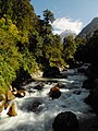
{{Infobox river | name = பிந்தர் ஆறு | name_native = | name_native_lang = | name_other = | name_etymology = | image = Pindari river 2, Uttarakhand, India.jpg | image_size = 300px | image_caption = செப்டம்பர் 2011-இல் பிந்தர் ஆறு | map = HeadwatersGanges1.jpg | map_size = | map_caption = வலது தொலைவில் பாயும் பிந்தர் ஆறு Pinder | pushpin_map = | pushpin_map_size = | pushpin_map_caption= | subdivision_type1 = நாடு | subdivision_name1 = இந்தியா | subdivision_type2 = மாநிலம் | subdivision_name2 = உத்தராகண்ட் | subdivision_type3 = பிரதேசம் | subdivision_name3 = குமாவுன் கோட்டம் | subdivision_type4 = மாவட்டம் | subdivision_name4 = பாகேஸ்வர் மாவட்டம் மற்றும் சமோலி மாவட்டம் | subdivision_type5 = | subdivision_name5 = | length = 105 km (65 mi) | width_min = | width_avg = | width_max = | depth_min = | depth_avg = | depth_max = | discharge1_location= | discharge1_min = | discharge1_avg = | discharge1_max = | source1 = பிந்தர் பனிக் கொடுமுடி | source1_location = | source1_coordinates= 30°17′N 80°01′E / 30.283°N 80.017°E | source1_elevation = 3,820 m (12,530 அடி) | source2 = | source2_location = | source2_coordinates= | source2_elevation = | mouth = அலக்நந்தா ஆறு | mouth_location = கர்ணபிரயாகை, உத்தராகண்ட் | mouth_coordinates = 30°15′49″N 79°13′00″E / 30.26361°N 79.21667°E | mouth_elevation = 1,450 m (4,760 அடி) | progression = | river_system = | basin_size = | tributaries_left = | tributaries_right =[[சாராதா ஆறு] | custom_label = | custom_data = | extra = }}
பிந்தர் ஆறு (Pindar River) இந்தியாவின் உத்தராகண்ட் மாநிலத்தின் குமாவுன் கோட்டத்தில் உள்ள பாகேஸ்வர் மாவட்டத்தின் இமயமலையில் 3,820 மீட்டர் உயரத்தில் உள்ள பிந்தர் பனிக்கொடுமுடிகளில்[1] உற்பத்தி ஆகும் பிந்தர் ஆறு, பாகேஸ்வர் மாவட்டம் மற்றும் சமோலி மாவட்டம்[2]
படக்காட்சிகள்
-
 உத்தராகண்டின் பிந்தர் பனிக்கொடிமுடிகளில் தோன்றும் பிந்தர் ஆறு
 -
 Pindari
 -
![கர்ணபிரயாகையில் ஒன்று கூடும் அலக்நந்தா ஆறு (மேல்), பிந்தர் ஆறு (கீழ்)]]](//upload.wikimedia.org/wikipedia/commons/thumb/2/25/Karnprayag.jpg/120px-Karnprayag.jpg) கர்ணபிரயாகையில் ஒன்று கூடும் அலக்நந்தா ஆறு (மேல்), பிந்தர் ஆறு (கீழ்)]]
கர்ணபிரயாகையில் ஒன்று கூடும் அலக்நந்தா ஆறு (மேல்), பிந்தர் ஆறு (கீழ்)]] -
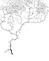 Pinder River (far right) in the map showing The Himalayan headwaters of the Ganges river in Uttarakhand


![கர்ணபிரயாகையில் ஒன்று கூடும் அலக்நந்தா ஆறு (மேல்), பிந்தர் ஆறு (கீழ்)]]](/wiki/%E0%AE%AA%E0%AE%9F%E0%AE%BF%E0%AE%AE%E0%AE%AE%E0%AF%8D:Karnprayag.jpg)

இதனையும் காண்க
மேற்கோள்கள்
- ↑ "Pindari Glacier". பார்க்கப்பட்ட நாள் 5 July 2019.
- ↑ "Pindar river in Uttarakhand". பார்க்கப்பட்ட நாள் 5 July 2019.