
படிமம்:RussiaContourMap.png
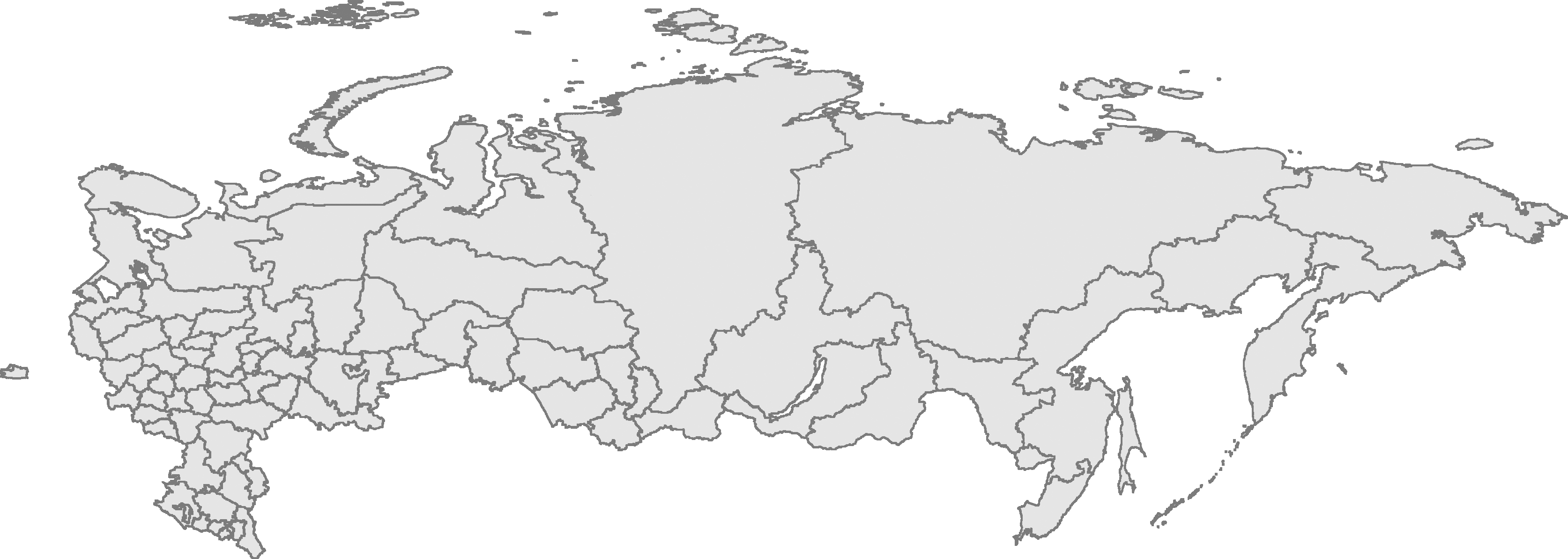
இந்த முன்னோட்டத்தின் அளவு: 800 × 285 படப்புள்ளிகள் . மற்ற பிரிதிறன்கள்: 320 × 114 படப்புள்ளிகள் | 640 × 228 படப்புள்ளிகள் | 1,024 × 365 படப்புள்ளிகள் | 1,280 × 456 படப்புள்ளிகள் | 3,347 × 1,193 படப்புள்ளிகள் .
மூலக்கோப்பு (3,347 × 1,193 படவணுக்கள், கோப்பின் அளவு: 305 KB, MIME வகை: image/png)
| இது விக்கிமீடியா பொதுக்கோப்பகத்தில் இருக்கும் ஒரு கோப்பாகும். இக்கோப்பைக் குறித்து அங்கே காணப்படும் படிம விளக்கப் பக்கத்தை இங்கே கீழே காணலாம்.
|
| விளக்கம் | Russian Federation contour map, based on Image:Russia-equirectang*1,5.png | ||
| நாள் | |||
| மூலம் | சொந்த முயற்சி | ||
| ஆசிரியர் | User:Kalan | ||
| அனுமதி (இக்கோப்பை மீண்டும் பயன்படுத்துதல்) |
|

|
This map image could be re-created using vector graphics as an SVG file. This has several advantages; see Commons:Media for cleanup for more information. If an SVG form of this image is available, please upload it and afterwards replace this template with
{{vector version available|new image name}}.
It is recommended to name the SVG file “RussiaContourMap.svg”—then the template Vector version available (or Vva) does not need the new image name parameter. |
கோப்பின் வரலாறு
குறித்த நேரத்தில் இருந்த படிமத்தைப் பார்க்க அந்நேரத்தின் மீது சொடுக்கவும்.
| நாள்/நேரம் | நகம் அளவு சிறுபடம் | அளவுகள் | பயனர் | கருத்து | |
|---|---|---|---|---|---|
| தற்போதைய | 23:56, 10 சனவரி 2009 | 3,347 × 1,193 (305 KB) | Чръный человек | {{Information |Description= |Source= |Date= |Author= |Permission= |other_versions= }} | |
| 23:12, 29 பெப்பிரவரி 2008 | 3,347 × 1,193 (95 KB) | Sasha Krotov | Забайкальский край | ||
| 17:01, 1 சனவரி 2008 | 3,347 × 1,193 (95 KB) | Sasha Krotov | Усть-Ордынский Бурятский автономный округ удалён | ||
| 16:38, 28 திசம்பர் 2007 | 3,347 × 1,193 (96 KB) | Sasha Krotov | Kamchatka fix | ||
| 20:28, 25 ஏப்பிரல் 2007 | 3,347 × 1,193 (88 KB) | Obersachse | {{Information |Description=Russian Federation contour map, based on Image:Russia-equirectang*1,5.png |Source={{{source|Own work}}} |Date={{{date|17 03 2007}}} |Author=User:Kalan |Permission={{PD-self}} |other_versions={{{otherversio | ||
| 10:15, 23 மார்ச்சு 2007 | 6,694 × 2,387 (191 KB) | Kalan | map is now up to date; enhanced borders | ||
| 09:29, 17 மார்ச்சு 2007 | 6,694 × 2,387 (163 KB) | Kalan | {{subst:User:Kalan/Me-PD|description=Russian Federation contour map, based on Image:Russia-equirectang*1,5.png}} Category:Russia Category:Maps |
கோப்பு பயன்பாடு
இப் படிமத்துக்கு இணைக்கப்பட்டுள்ள பக்கங்கள் எதுவும் இல்லை.
கோப்பின் முழுமையான பயன்பாடு
கீழ்கண்ட மற்ற விக்கிகள் இந்த கோப்பை பயன்படுத்துகின்றன:
- ba.wikipedia.org-திட்டத்தில் இதன் பயன்பாடு
- bg.wikipedia.org-திட்டத்தில் இதன் பயன்பாடு
- de.wikipedia.org-திட்டத்தில் இதன் பயன்பாடு
- en.wikisource.org-திட்டத்தில் இதன் பயன்பாடு
- es.wikipedia.org-திட்டத்தில் இதன் பயன்பாடு
- mk.wikipedia.org-திட்டத்தில் இதன் பயன்பாடு
- nl.wikipedia.org-திட்டத்தில் இதன் பயன்பாடு
- ro.wikipedia.org-திட்டத்தில் இதன் பயன்பாடு
- ru.wikipedia.org-திட்டத்தில் இதன் பயன்பாடு
- szl.wikipedia.org-திட்டத்தில் இதன் பயன்பாடு
- Kalińingrad
- Moskwa
- Uljanowsk
- Pejtersburg
- Kamyszin
- Murmańsk
- Władywostok
- Smoleńsk
- Kondopoga
- Taganrog
- Czelabińsk
- Puszkin (mjasto)
- Tambow
- Saratow
- Nieriungri
- Jekaterinburg
- Brjańsk
- Machaczkala
- Kazań
- Samara
- Ńiżńij Nowgorod
- Elista
- Ułan-Ude
- Ufa
- Gorno-Ałtajsk
- Nalczik
- Czerkesk
- Jakuck
- Kyzył
- Abakan
- Czeboksary
- Rostow na Donu
- Ńagań
- Iżewsk
- Soczi
- Jarosław (mjasto we Rusyji)
- Rossosz (Rusyjo)
சிறப்பு பக்கம்-மொத்த பயன்பாடு - இதன் மூலம் இந்த கோப்பின் மொத்த பயன்பாட்டை அறிய முடியும்