
படிமம்:PIA19606-Ceres-Dawn-GlobalMap-MtnCrop-20150728.jpg

PIA19606-Ceres-Dawn-GlobalMap-MtnCrop-20150728.jpg (158 × 156 படவணுக்கள், கோப்பின் அளவு: 5 KB, MIME வகை: image/jpeg)
| இது விக்கிமீடியா பொதுக்கோப்பகத்தில் இருக்கும் ஒரு கோப்பாகும். இக்கோப்பைக் குறித்து அங்கே காணப்படும் படிம விளக்கப் பக்கத்தை இங்கே கீழே காணலாம்.
|
சுருக்கம்
| விளக்கம் |
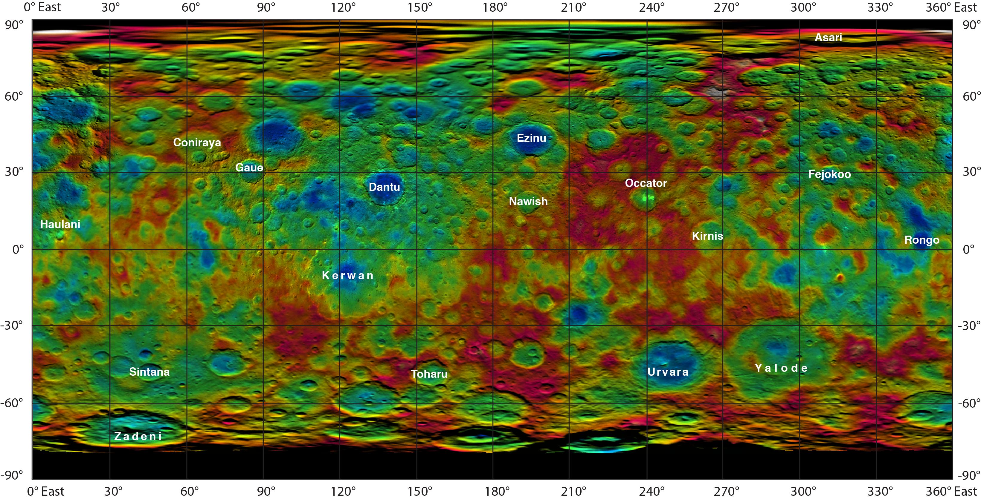
English: PIA19606: Topographic Ceres Map With Crater Names
CROP - PYRAMID-SHAPED MOUNTAIN ON CERES. http://photojournal.jpl.nasa.gov/catalog/PIA19606 http://photojournal.jpl.nasa.gov/jpeg/PIA19606.jpg => Annotated map version
This color-coded map from NASA's Dawn mission shows the highs and lows of topography on the surface of dwarf planet Ceres. It is labeled with names of features approved by the International Astronomical Union. Occator, the mysterious crater containing Ceres' mysterious bright spots, is named after the Roman agriculture deity of harrowing, a method of leveling soil. They retain their bright appearance in this map, although they are color-coded in the same green elevation of the crater floor in which they sit. The color scale extends about 5 miles (7.5 kilometers) below the surface in indigo to 5 miles (7.5 kilometers) above the surface in white. The topographic map was constructed from analyzing images from Dawn's framing camera taken from varying sun and viewing angles. The map was combined with an image mosaic of Ceres and projected as an simple cylindrical projection. Note: The elevation scale used for this topographic map product differs slightly from the scale used to create PIA19605. These are preliminary data products; the Dawn science team may revisit the data to standardize the scale at a later date. Dawn's mission is managed by JPL for NASA's Science Mission Directorate in Washington. Dawn is a project of the directorate's Discovery Program, managed by NASA's Marshall Space Flight Center in Huntsville, Alabama. UCLA is responsible for overall Dawn mission science. Orbital ATK, Inc., in Dulles, Virginia, designed and built the spacecraft. The German Aerospace Center, the Max Planck Institute for Solar System Research, the Italian Space Agency and the Italian National Astrophysical Institute are international partners on the mission team. For a complete list of acknowledgments, see http://dawn.jpl.nasa.gov/mission. For more information about the Dawn mission, visit http://dawn.jpl.nasa.gov. |
| நாள் | |
| மூலம் | http://photojournal.jpl.nasa.gov/figures/PIA19606_fig1.jpg |
| ஆசிரியர் | NASA/JPL-Caltech/UCLA/MPS/DLR/IDA |
| ஒத்தக்கோப்பு |
|


அனுமதி
| This file is in the public domain in the United States because it was solely created by NASA. NASA copyright policy states that "NASA material is not protected by copyright unless noted". (See Template:PD-USGov, NASA copyright policy page or JPL Image Use Policy.) | ||
 |
Warnings:
|
கோப்பின் வரலாறு
குறித்த நேரத்தில் இருந்த படிமத்தைப் பார்க்க அந்நேரத்தின் மீது சொடுக்கவும்.
| நாள்/நேரம் | நகம் அளவு சிறுபடம் | அளவுகள் | பயனர் | கருத்து | |
|---|---|---|---|---|---|
| தற்போதைய | 11:13, 28 ஆகத்து 2015 | | 158 × 156 (5 KB) | Tomruen | Reverted to version as of 01:24, 29 July 2015 |
| 01:27, 29 சூலை 2015 |  | 640 × 632 (30 KB) | Drbogdan | enlarged from 158x156/4.84KB to 640x632/29.6KB - via JASC Paint Shop Pro v6.02 | |
| 01:24, 29 சூலை 2015 |  | 158 × 156 (5 KB) | Drbogdan | User created page with UploadWizard |
கோப்பு பயன்பாடு
பின்வரும் பக்க இணைப்புகள் இப் படிமத்துக்கு இணைக்கபட்டுள்ளது(ளன):
கோப்பின் முழுமையான பயன்பாடு
கீழ்கண்ட மற்ற விக்கிகள் இந்த கோப்பை பயன்படுத்துகின்றன:
- fr.wikipedia.org-திட்டத்தில் இதன் பயன்பாடு
- zh.wikipedia.org-திட்டத்தில் இதன் பயன்பாடு