
படிமம்:Near East 1400 BCE.png

இந்த முன்னோட்டத்தின் அளவு: 750 × 600 படப்புள்ளிகள் . மற்ற பிரிதிறன்கள்: 300 × 240 படப்புள்ளிகள் | 600 × 480 படப்புள்ளிகள் | 785 × 628 படப்புள்ளிகள் .
மூலக்கோப்பு (785 × 628 படவணுக்கள், கோப்பின் அளவு: 146 KB, MIME வகை: image/png)
| இது விக்கிமீடியா பொதுக்கோப்பகத்தில் இருக்கும் ஒரு கோப்பாகும். இக்கோப்பைக் குறித்து அங்கே காணப்படும் படிம விளக்கப் பக்கத்தை இங்கே கீழே காணலாம்.
|

|
This historical map image could be re-created using vector graphics as an SVG file. This has several advantages; see Commons:Media for cleanup for more information. If an SVG form of this image is available, please upload it and afterwards replace this template with
{{vector version available|new image name}}.
It is recommended to name the SVG file “Near East 1400 BCE.svg”—then the template Vector version available (or Vva) does not need the new image name parameter. |
சுருக்கம்
| விளக்கம் |
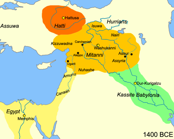
English: Map of the near east circa 1400 BCE.
עברית: מפת אזור המזרח הקרוב חלוקה לאימפריות בשנת 1400 לפנה"ס |
| நாள் | |
| மூலம் |
சொந்த முயற்சி
|
| ஆசிரியர் | Javierfv1212 |
| ஒத்தக்கோப்பு |
[]
|


அனுமதி
| This work has been released into the public domain by its author, Javierfv1212 at ஆங்கிலம் விக்கிப்பீடியா. This applies worldwide. சில நாடுகளில் இது சாத்தியமில்லாது போகலாம். அவ்வாறாயின் : Javierfv1212 grants anyone the right to use this work for any purpose, without any conditions, unless such conditions are required by law. |
Original upload log
The original description page was here. All following user names refer to en.wikipedia.
- 2010-03-21 22:10 Javierfv1212 785×628× (149438 bytes) {{Information |Description = Map of the near east circa 1400 BCE. |Source = I (~~~) created this work entirely by myself. Source: Cambridge Ancient History Vol II Middle East & Aegean Region 1800-1300. I. E. S. EDWARDS (Ed) et al. |Date
கோப்பின் வரலாறு
குறித்த நேரத்தில் இருந்த படிமத்தைப் பார்க்க அந்நேரத்தின் மீது சொடுக்கவும்.
| நாள்/நேரம் | நகம் அளவு சிறுபடம் | அளவுகள் | பயனர் | கருத்து | |
|---|---|---|---|---|---|
| தற்போதைய | 15:41, 3 சூலை 2010 | | 785 × 628 (146 KB) | Hanay | {{Information |Description={{en|1=Map of the near east circa 1400 BCE. }} {{he|1=מפת אזור המזרח הקרוב חלוקה לאימפריות בשנת 1400 לפנה"ס}} |Source=http://en.wikipedia.org/wiki/File:Near_East_1400_BCE.png |Author=[[Use |
கோப்பு பயன்பாடு
பின்வரும் 3 பக்கங்கள் இணைப்பு இப் படிமத்துக்கு இணைக்கபட்டுள்ளது(ளன):
கோப்பின் முழுமையான பயன்பாடு
கீழ்கண்ட மற்ற விக்கிகள் இந்த கோப்பை பயன்படுத்துகின்றன:
- af.wikipedia.org-திட்டத்தில் இதன் பயன்பாடு
- ast.wikipedia.org-திட்டத்தில் இதன் பயன்பாடு
- azb.wikipedia.org-திட்டத்தில் இதன் பயன்பாடு
- az.wikipedia.org-திட்டத்தில் இதன் பயன்பாடு
- be-tarask.wikipedia.org-திட்டத்தில் இதன் பயன்பாடு
- bg.wikipedia.org-திட்டத்தில் இதன் பயன்பாடு
- bn.wikipedia.org-திட்டத்தில் இதன் பயன்பாடு
- ca.wikipedia.org-திட்டத்தில் இதன் பயன்பாடு
- ceb.wikipedia.org-திட்டத்தில் இதன் பயன்பாடு
- cs.wikipedia.org-திட்டத்தில் இதன் பயன்பாடு
- cv.wikipedia.org-திட்டத்தில் இதன் பயன்பாடு
- da.wikipedia.org-திட்டத்தில் இதன் பயன்பாடு
- el.wikipedia.org-திட்டத்தில் இதன் பயன்பாடு
- en.wikipedia.org-திட்டத்தில் இதன் பயன்பாடு
- en.wiktionary.org-திட்டத்தில் இதன் பயன்பாடு
- et.wikipedia.org-திட்டத்தில் இதன் பயன்பாடு
- fa.wikipedia.org-திட்டத்தில் இதன் பயன்பாடு
- fr.wikipedia.org-திட்டத்தில் இதன் பயன்பாடு
- he.wikipedia.org-திட்டத்தில் இதன் பயன்பாடு
- hr.wikipedia.org-திட்டத்தில் இதன் பயன்பாடு
- hy.wikipedia.org-திட்டத்தில் இதன் பயன்பாடு
- hyw.wikipedia.org-திட்டத்தில் இதன் பயன்பாடு
- incubator.wikimedia.org-திட்டத்தில் இதன் பயன்பாடு
- it.wikipedia.org-திட்டத்தில் இதன் பயன்பாடு
சிறப்பு பக்கம்-மொத்த பயன்பாடு - இதன் மூலம் இந்த கோப்பின் மொத்த பயன்பாட்டை அறிய முடியும்