
படிமம்:Nansen Greenland Crossing Map.png

இந்த முன்னோட்டத்தின் அளவு: 550 × 599 படப்புள்ளிகள் . மற்ற பிரிதிறன்கள்: 220 × 240 படப்புள்ளிகள் | 626 × 682 படப்புள்ளிகள் .
மூலக்கோப்பு (626 × 682 படவணுக்கள், கோப்பின் அளவு: 55 KB, MIME வகை: image/png)
| இது விக்கிமீடியா பொதுக்கோப்பகத்தில் இருக்கும் ஒரு கோப்பாகும். இக்கோப்பைக் குறித்து அங்கே காணப்படும் படிம விளக்கப் பக்கத்தை இங்கே கீழே காணலாம்.
|
சுருக்கம்
| விளக்கம் |
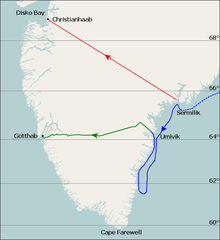
English: Map of Fridtjof Nansen's 1888 route across Greenland, the first crossing of the island.
Dotted line is the ship Jason's journey from Iceland to near Sermilik fjord (now known as Sermiligaaq), continuous blue line is the journey made by Nansen and his companions in two small boats trying to reach the coast. Planned journey from Sermilik northwest to Christianhaab (today known as Qasigiannguit). Nansen's actual journey across Greenland from Umivik fjord to Gothaab (today known as Nuuk). Deutsch: Die gepunktete Linie zeigt die Fahrt der Jason bis zum 17. Juli. Die durchgezogene Linie zeigt die Eisdrift bis zum 29. Juli und die Küstenwanderung bis zum 11. August. Die ursprünglich geplante Route von Sermilik nach Christianshåb. Die wirkliche Route vom 15. August bis 3. Oktober. |
| நாள் | |
| மூலம் | Base map is File:Location map Greenland Southern.png, sea (blue) and land (green) journey lines based on File:NansenGreenlandrevisedMap.jpg, published 1888. Latitude lines based on Google Earth sateliite photos. |
| ஆசிரியர் | Base map is from OpenStreetMap by User:Dr. Blofeld, labels, latitude lines, and journey lines added by Ruhrfisch (talk) |
| அனுமதி (இக்கோப்பை மீண்டும் பயன்படுத்துதல்) |
GFDL, CC-BY-SA |
| ஒத்தக்கோப்பு |
 |
அனுமதி
இந்த ஆக்கத்தின் காப்புரிமையாளரான நான் இதனைப் பின்வரும் உரிமத்தின் கீழ் வெளியிடுகின்றேன்:

|
GNU Free Documentation License விதிமுறைகளின் கீழ் இந்த ஆவணத்தை நகலெடுக்க, விநியோகிக்க மற்றும்/அல்லது மாற்றுவதற்கு அனுமதி வழங்கப்பட்டுள்ளது, Free Software Foundation;ஆல் வெளியிடப்பட்ட பதிப்பு 1.2 அல்லது அதற்குப் பிந்தைய பதிப்பு, மாற்றமில்லாத பிரிவுகள், முன் அட்டை உரைகள் மற்றும் பின் அட்டை உரைகள் இல்லாமல் வெளியிடப்பட்டது. GNU Free Documentation License என்ற தலைப்பில் உரிமத்தின் நகல் சேர்க்கப்பட்டுள்ளது. |
This file is licensed under the Creative Commons Attribution-Share Alike 4.0 International, 3.0 Unported, 2.5 Generic, 2.0 Generic and 1.0 Generic license.
- நீங்கள் சுதந்திரமாக:
- பகிர்ந்து கொள்ள – வேலையை நகலெடுக்க, விநியோகிக்க மற்றும் அனுப்ப
- மீண்டும் கலக்க – வேலைக்கு பழகிக்கொள்ள.
- கீழ்க்காணும் விதிகளுக்கு ஏற்ப,
- பண்புக்கூறுகள் – நீங்கள் பொருத்தமான உரிமையை வழங்க வேண்டும், உரிமத்திற்கான இணைப்பை வழங்க வேண்டும் மற்றும் மாற்றங்கள் செய்யப்பட்டிருந்தால் குறிப்பிட வேண்டும். நீங்கள் ஏற்புடைய எந்த முறையிலும் அவ்வாறு செய்யலாம், ஆனால் எந்த வகையிலும் உரிமதாரர் உங்களை அல்லது உங்கள் பயன்பாட்டிற்கு ஒப்புதல் அளிக்கும் படி பரிந்துரைக்க கூடாது.
- அதே மாதிரி பகிர் – நீங்கள் ரீமிக்ஸ் செய்தாலோ, உருமாற்றம் செய்தாலோ அல்லது பொருளை உருவாக்கினாலோ, உங்கள் பங்களிப்புகளை அல்லது இணக்கமான உரிமம் கீழ் அசலாக விநியோகிக்க வேண்டும்.
நீர் உமக்கு விருப்பமான உரிமத்தை தேர்ந்தெடுக்கலாம்.
கோப்பின் வரலாறு
குறித்த நேரத்தில் இருந்த படிமத்தைப் பார்க்க அந்நேரத்தின் மீது சொடுக்கவும்.
| நாள்/நேரம் | நகம் அளவு சிறுபடம் | அளவுகள் | பயனர் | கருத்து | |
|---|---|---|---|---|---|
| தற்போதைய | 21:08, 7 ஆகத்து 2010 | | 626 × 682 (55 KB) | Ruhrfisch | Extend green line along fjord to Godthab, make blue line dotted at first. All other information is the same. |
| 14:54, 7 ஆகத்து 2010 |  | 626 × 682 (55 KB) | Ruhrfisch | {{Information |Description= Map of Fridtjof Nansen's 1888 route across Greenland, the first crosing of the island. Ocean journey is blue, land journey is green, proposed original journey route is red. |Source= Base map is [[:File:Location map Greenland So |
கோப்பு பயன்பாடு
பின்வரும் பக்க இணைப்புகள் இப் படிமத்துக்கு இணைக்கபட்டுள்ளது(ளன):
கோப்பின் முழுமையான பயன்பாடு
கீழ்கண்ட மற்ற விக்கிகள் இந்த கோப்பை பயன்படுத்துகின்றன:
- ba.wikipedia.org-திட்டத்தில் இதன் பயன்பாடு
- be.wikipedia.org-திட்டத்தில் இதன் பயன்பாடு
- bg.wikipedia.org-திட்டத்தில் இதன் பயன்பாடு
- de.wikipedia.org-திட்டத்தில் இதன் பயன்பாடு
- en.wikipedia.org-திட்டத்தில் இதன் பயன்பாடு
- eo.wikipedia.org-திட்டத்தில் இதன் பயன்பாடு
- es.wikipedia.org-திட்டத்தில் இதன் பயன்பாடு
- fr.wikipedia.org-திட்டத்தில் இதன் பயன்பாடு
- he.wikipedia.org-திட்டத்தில் இதன் பயன்பாடு
- hr.wikipedia.org-திட்டத்தில் இதன் பயன்பாடு
- hy.wikipedia.org-திட்டத்தில் இதன் பயன்பாடு
- id.wikipedia.org-திட்டத்தில் இதன் பயன்பாடு
- nn.wikipedia.org-திட்டத்தில் இதன் பயன்பாடு
- pt.wikipedia.org-திட்டத்தில் இதன் பயன்பாடு
- ro.wikipedia.org-திட்டத்தில் இதன் பயன்பாடு
- rue.wikipedia.org-திட்டத்தில் இதன் பயன்பாடு
- ru.wikipedia.org-திட்டத்தில் இதன் பயன்பாடு
- sl.wikipedia.org-திட்டத்தில் இதன் பயன்பாடு
- uk.wikipedia.org-திட்டத்தில் இதன் பயன்பாடு