படிமம்:Mayamap.png

இந்த முன்னோட்டத்தின் அளவு: 800 × 588 படப்புள்ளிகள் . மற்ற பிரிதிறன்கள்: 320 × 235 படப்புள்ளிகள் | 640 × 470 படப்புள்ளிகள் | 1,024 × 752 படப்புள்ளிகள் | 1,074 × 789 படப்புள்ளிகள் .
மூலக்கோப்பு (1,074 × 789 படவணுக்கள், கோப்பின் அளவு: 1,010 KB, MIME வகை: image/png)
கோப்பின் வரலாறு
குறித்த நேரத்தில் இருந்த படிமத்தைப் பார்க்க அந்நேரத்தின் மீது சொடுக்கவும்.
| நாள்/நேரம் | நகம் அளவு சிறுபடம் | அளவுகள் | பயனர் | கருத்து | |
|---|---|---|---|---|---|
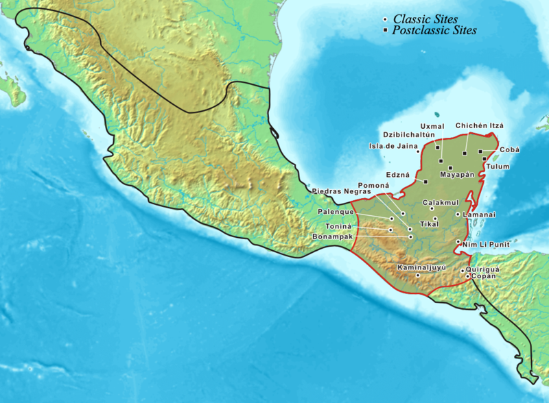
| தற்போதைய | 20:27, 20 சூலை 2006 |  | 1,074 × 789 (1,010 KB) | Kmusser | Map showing the extent of the Maya civilization, adopted from Mayas.png. |
கோப்பு பயன்பாடு
பின்வரும் 2 பக்கங்கள் இணைப்பு இப் படிமத்துக்கு இணைக்கபட்டுள்ளது(ளன):
கோப்பின் முழுமையான பயன்பாடு
கீழ்கண்ட மற்ற விக்கிகள் இந்த கோப்பை பயன்படுத்துகின்றன:
- af.wikipedia.org-திட்டத்தில் இதன் பயன்பாடு
- ar.wikipedia.org-திட்டத்தில் இதன் பயன்பாடு
- azb.wikipedia.org-திட்டத்தில் இதன் பயன்பாடு
- az.wikipedia.org-திட்டத்தில் இதன் பயன்பாடு
- ba.wikipedia.org-திட்டத்தில் இதன் பயன்பாடு
- be-tarask.wikipedia.org-திட்டத்தில் இதன் பயன்பாடு
- bg.wikipedia.org-திட்டத்தில் இதன் பயன்பாடு
- bo.wikipedia.org-திட்டத்தில் இதன் பயன்பாடு
- br.wikipedia.org-திட்டத்தில் இதன் பயன்பாடு
- ca.wikipedia.org-திட்டத்தில் இதன் பயன்பாடு
- cs.wikipedia.org-திட்டத்தில் இதன் பயன்பாடு
- cy.wikipedia.org-திட்டத்தில் இதன் பயன்பாடு
- da.wikipedia.org-திட்டத்தில் இதன் பயன்பாடு
- diq.wikipedia.org-திட்டத்தில் இதன் பயன்பாடு
- el.wikipedia.org-திட்டத்தில் இதன் பயன்பாடு
- en.wikipedia.org-திட்டத்தில் இதன் பயன்பாடு
- Belize
- Tikal
- Maya peoples
- List of conflicts in North America
- User:Kmusser/Images
- List of Maya sites
- Maya civilization
- User talk:Jayantanth/Archive 1
- Pre-Columbian Belize
- History of Belize
- Maya city
- User:Wiki Raja/Gallery
- List of conflicts in Mexico
- Wikipedia:Wikipedia Signpost/2015-08-05/Featured content
- Wikipedia:Wikipedia Signpost/Single/2015-08-05
- Talk:Maya civilization/WTF
- Portal:Civilizations
- User:SomeGuyWhoRandomlyEdits/List of conflicts in Mexico
- en.wikibooks.org-திட்டத்தில் இதன் பயன்பாடு
- es.wikipedia.org-திட்டத்தில் இதன் பயன்பாடு
- et.wikipedia.org-திட்டத்தில் இதன் பயன்பாடு
- eu.wikipedia.org-திட்டத்தில் இதன் பயன்பாடு
- fa.wikipedia.org-திட்டத்தில் இதன் பயன்பாடு
- fi.wikipedia.org-திட்டத்தில் இதன் பயன்பாடு
- fr.wikipedia.org-திட்டத்தில் இதன் பயன்பாடு
- gl.wikipedia.org-திட்டத்தில் இதன் பயன்பாடு
சிறப்பு பக்கம்-மொத்த பயன்பாடு - இதன் மூலம் இந்த கோப்பின் மொத்த பயன்பாட்டை அறிய முடியும்


