
படிமம்:Map of Long Valley Mono area.png

இந்த முன்னோட்டத்தின் அளவு: 538 × 599 படப்புள்ளிகள் . மற்ற பிரிதிறன்கள்: 216 × 240 படப்புள்ளிகள் | 600 × 668 படப்புள்ளிகள் .
மூலக்கோப்பு (600 × 668 படவணுக்கள், கோப்பின் அளவு: 178 KB, MIME வகை: image/png)
| இது விக்கிமீடியா பொதுக்கோப்பகத்தில் இருக்கும் ஒரு கோப்பாகும். இக்கோப்பைக் குறித்து அங்கே காணப்படும் படிம விளக்கப் பக்கத்தை இங்கே கீழே காணலாம்.
|
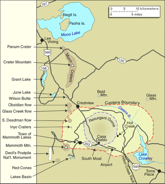
| விளக்கம் | United States Geological Survey map of the Long Valley Caldera and Mono Lake, California | |||
| நாள் | by 1999 | |||
| மூலம் | Archived source link | |||
| ஆசிரியர் | USGS | |||
| அனுமதி (இக்கோப்பை மீண்டும் பயன்படுத்துதல்) |
|
|||
| ஒத்தக்கோப்பு |

கோப்பின் வரலாறு
குறித்த நேரத்தில் இருந்த படிமத்தைப் பார்க்க அந்நேரத்தின் மீது சொடுக்கவும்.
| நாள்/நேரம் | நகம் அளவு சிறுபடம் | அளவுகள் | பயனர் | கருத்து | |
|---|---|---|---|---|---|
| தற்போதைய | 15:24, 21 சூன் 2005 | | 600 × 668 (178 KB) | Hike395 | United States Geological Survey map of the Long Valley Caldera and Mono Lake, California {{PD-USGov-USGS}} Source URL: http://lvo.wr.usgs.gov/gallery/MapGallery.html |
கோப்பு பயன்பாடு
இப் படிமத்துக்கு இணைக்கப்பட்டுள்ள பக்கங்கள் எதுவும் இல்லை.