
படிமம்:MapCambodiaByFussi.png

இந்த முன்னோட்டத்தின் அளவு: 719 × 600 படப்புள்ளிகள் . மற்ற பிரிதிறன்கள்: 288 × 240 படப்புள்ளிகள் | 576 × 480 படப்புள்ளிகள் | 921 × 768 படப்புள்ளிகள் | 1,228 × 1,024 படப்புள்ளிகள் | 2,456 × 2,048 படப்புள்ளிகள் | 3,012 × 2,512 படப்புள்ளிகள் .
மூலக்கோப்பு (3,012 × 2,512 படவணுக்கள், கோப்பின் அளவு: 976 KB, MIME வகை: image/png)
| இது விக்கிமீடியா பொதுக்கோப்பகத்தில் இருக்கும் ஒரு கோப்பாகும். இக்கோப்பைக் குறித்து அங்கே காணப்படும் படிம விளக்கப் பக்கத்தை இங்கே கீழே காணலாம்.
|
சுருக்கம்
| விளக்கம் |
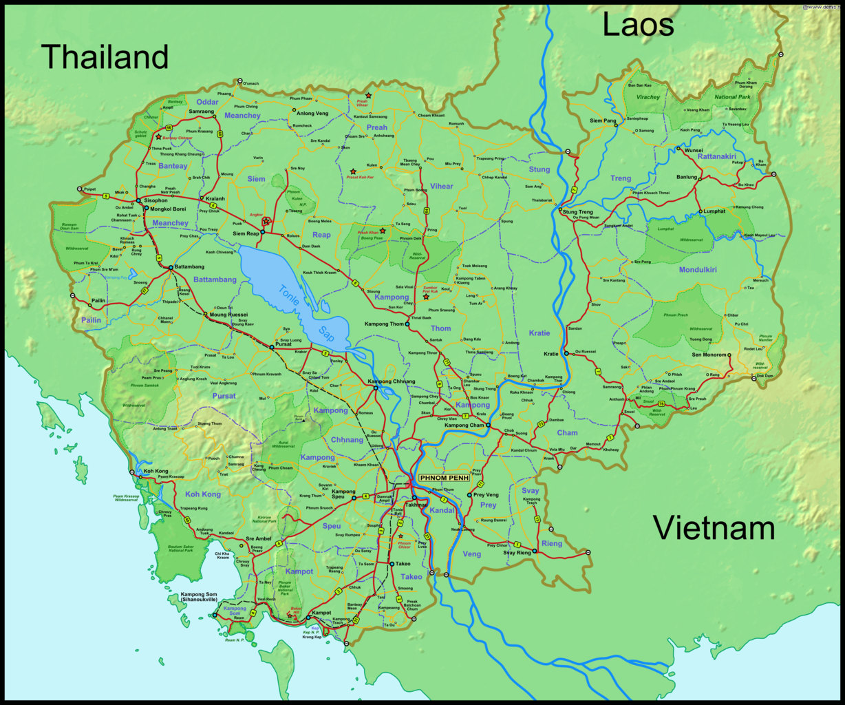
Deutsch: Karte von Kambodscha (Version 1.06)
English: Map of Cambodia (Version 1.06) |
|||||||||||||||||
| நாள் | ||||||||||||||||||
| மூலம் |
சொந்த முயற்சி - self drawn map own work based on data from Demis.nl |
|||||||||||||||||
| ஆசிரியர் |
|
|||||||||||||||||

அனுமதி
This image is in the public domain because it came from the site https://www.demis.nl/products/web-map-server/examples/ and was released by the copyright holder. Permission is granted to copy, distribute and/or modify this map since it is based on free of copyright images from: www.demis.nl. See also approval email on de.wp and its clarification.
|
| This work has been released into the public domain by its copyright holder, www.demis.nl. This applies worldwide. சில நாடுகளில் இது சாத்தியமில்லாது போகலாம். அவ்வாறாயின் : www.demis.nl grants anyone the right to use this work for any purpose, without any conditions, unless such conditions are required by law.
|
Original upload log
| This file was imported from Wikivoyage Shared. |
The original description page was here. All following user names refer to wikivoyage-old/shared.
- 2007-02-13 13:29 DerFussi archive copy at the Wayback Machine 3012×2512 (4660905 bytes) == Beschreibung == {{Information |Description={{En|Map of the Cambodia (Version 1.0)}} {{De|Karte von [[:de:Kambodscha|Kambodscha]] (Version 1.0)}} |Author=Stefan Fussan - [[User:DerFussi|Der Fussi]] |Date=13. February 2007 |Source={{En|self-made}} {{De|s
- 2007-03-08 06:08 DerFussi archive copy at the Wayback Machine 3012×2512 (4670153 bytes) V1.01 - Da fehlte eine Provinzgrenze und ein Name
- 2007-07-10 04:59 DerFussi archive copy at the Wayback Machine 3012×2512 (999484 bytes)
கோப்பின் வரலாறு
குறித்த நேரத்தில் இருந்த படிமத்தைப் பார்க்க அந்நேரத்தின் மீது சொடுக்கவும்.
| நாள்/நேரம் | நகம் அளவு சிறுபடம் | அளவுகள் | பயனர் | கருத்து | |
|---|---|---|---|---|---|
| தற்போதைய | 10:48, 14 நவம்பர் 2012 | | 3,012 × 2,512 (976 KB) | MGA73bot2 | {{BotMoveToCommons|shared.oldwikivoyage|year={{subst:CURRENTYEAR}}|month={{subst:CURRENTMONTHNAME}}|day={{subst:CURRENTDAY}}}} == {{int:filedesc}} == {{Information |description={{En|Map of Cambodia (Version 1.06)}} {{De|Karte von Kambodscha (Version 1.... |
கோப்பு பயன்பாடு
பின்வரும் பக்க இணைப்புகள் இப் படிமத்துக்கு இணைக்கபட்டுள்ளது(ளன):
கோப்பின் முழுமையான பயன்பாடு
கீழ்கண்ட மற்ற விக்கிகள் இந்த கோப்பை பயன்படுத்துகின்றன:
- bn.wikipedia.org-திட்டத்தில் இதன் பயன்பாடு
- de.wikivoyage.org-திட்டத்தில் இதன் பயன்பாடு
- en.wikipedia.org-திட்டத்தில் இதன் பயன்பாடு
- fr.wikipedia.org-திட்டத்தில் இதன் பயன்பாடு
- it.wikipedia.org-திட்டத்தில் இதன் பயன்பாடு
- th.wikipedia.org-திட்டத்தில் இதன் பயன்பாடு
- uk.wikipedia.org-திட்டத்தில் இதன் பயன்பாடு
- uz.wikipedia.org-திட்டத்தில் இதன் பயன்பாடு
- vi.wikipedia.org-திட்டத்தில் இதன் பயன்பாடு