
படிமம்:Loessplateau-kl.jpg
இதைவிட அளவில் பெரிய படிமம் இல்லை.
Loessplateau-kl.jpg (500 × 444 படவணுக்கள், கோப்பின் அளவு: 31 KB, MIME வகை: image/jpeg)
| இது விக்கிமீடியா பொதுக்கோப்பகத்தில் இருக்கும் ஒரு கோப்பாகும். இக்கோப்பைக் குறித்து அங்கே காணப்படும் படிம விளக்கப் பக்கத்தை இங்கே கீழே காணலாம்.
|

|
This map image could be re-created using vector graphics as an SVG file. This has several advantages; see Commons:Media for cleanup for more information. If an SVG form of this image is available, please upload it and afterwards replace this template with
{{vector version available|new image name}}.
It is recommended to name the SVG file “Loessplateau-kl.svg”—then the template Vector version available (or Vva) does not need the new image name parameter. |


சுருக்கம்
| விளக்கம் |
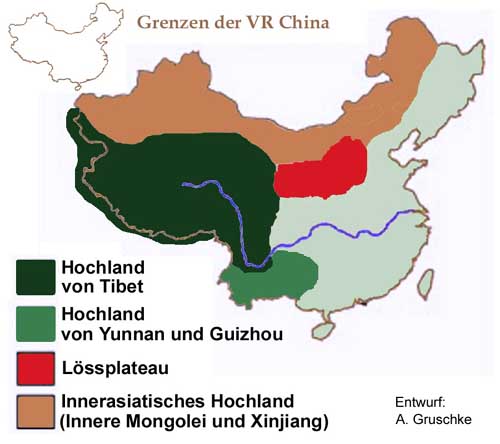
Deutsch: Karte der Hochländer in China |
| நாள் | |
| மூலம் | Andreas Gruschke (Entwurf und Ausführung) |
| ஆசிரியர் | Andreas Gruschke |
அனுமதி
This file is licensed under the Creative Commons Attribution-Share Alike 2.0 Germany license.
- நீங்கள் சுதந்திரமாக:
- பகிர்ந்து கொள்ள – வேலையை நகலெடுக்க, விநியோகிக்க மற்றும் அனுப்ப
- மீண்டும் கலக்க – வேலைக்கு பழகிக்கொள்ள.
- கீழ்க்காணும் விதிகளுக்கு ஏற்ப,
- பண்புக்கூறுகள் – நீங்கள் பொருத்தமான உரிமையை வழங்க வேண்டும், உரிமத்திற்கான இணைப்பை வழங்க வேண்டும் மற்றும் மாற்றங்கள் செய்யப்பட்டிருந்தால் குறிப்பிட வேண்டும். நீங்கள் ஏற்புடைய எந்த முறையிலும் அவ்வாறு செய்யலாம், ஆனால் எந்த வகையிலும் உரிமதாரர் உங்களை அல்லது உங்கள் பயன்பாட்டிற்கு ஒப்புதல் அளிக்கும் படி பரிந்துரைக்க கூடாது.
- அதே மாதிரி பகிர் – நீங்கள் ரீமிக்ஸ் செய்தாலோ, உருமாற்றம் செய்தாலோ அல்லது பொருளை உருவாக்கினாலோ, உங்கள் பங்களிப்புகளை அல்லது இணக்கமான உரிமம் கீழ் அசலாக விநியோகிக்க வேண்டும்.

Original upload log
Transferred from de.wikipedia to Commons by Wdwdbot using CommonsHelper.
The original description page was here. All following user names refer to de.wikipedia.
- 2008-07-22 07:38 Gruschke 500×444× (31905 bytes) {{Information |Beschreibung = Karte der Hochländer in China |Quelle = Andreas Gruschke (Entwurf und Ausführung) |Urheber = Andreas Gruschke |Datum = 22.07.2008 |Genehmigung = |Andere Versionen = |Anmerkungen = }}
கோப்பின் வரலாறு
குறித்த நேரத்தில் இருந்த படிமத்தைப் பார்க்க அந்நேரத்தின் மீது சொடுக்கவும்.
| நாள்/நேரம் | நகம் அளவு சிறுபடம் | அளவுகள் | பயனர் | கருத்து | |
|---|---|---|---|---|---|
| தற்போதைய | 19:02, 14 செப்டெம்பர் 2013 | | 500 × 444 (31 KB) | File Upload Bot (Magnus Manske) | Transfered from de.wikipedia by User:wdwdbot using CommonsHelper |
கோப்பு பயன்பாடு
பின்வரும் பக்க இணைப்புகள் இப் படிமத்துக்கு இணைக்கபட்டுள்ளது(ளன):
கோப்பின் முழுமையான பயன்பாடு
கீழ்கண்ட மற்ற விக்கிகள் இந்த கோப்பை பயன்படுத்துகின்றன:
- bg.wikipedia.org-திட்டத்தில் இதன் பயன்பாடு
- de.wikipedia.org-திட்டத்தில் இதன் பயன்பாடு
- en.wikipedia.org-திட்டத்தில் இதன் பயன்பாடு
- hr.wikipedia.org-திட்டத்தில் இதன் பயன்பாடு
- id.wikipedia.org-திட்டத்தில் இதன் பயன்பாடு
- nl.wikipedia.org-திட்டத்தில் இதன் பயன்பாடு
- sr.wikipedia.org-திட்டத்தில் இதன் பயன்பாடு