
படிமம்:Location map Fatih.jpg
மூலக்கோப்பு (1,957 × 1,929 படவணுக்கள், கோப்பின் அளவு: 822 KB, MIME வகை: image/jpeg)
| இது விக்கிமீடியா பொதுக்கோப்பகத்தில் இருக்கும் ஒரு கோப்பாகும். இக்கோப்பைக் குறித்து அங்கே காணப்படும் படிம விளக்கப் பக்கத்தை இங்கே கீழே காணலாம்.
|

|
This map image could be re-created using vector graphics as an SVG file. This has several advantages; see Commons:Media for cleanup for more information. If an SVG form of this image is available, please upload it and afterwards replace this template with
{{vector version available|new image name}}.
It is recommended to name the SVG file “Location map Fatih.svg”—then the template Vector version available (or Vva) does not need the new image name parameter. |


சுருக்கம்
| விளக்கம் |
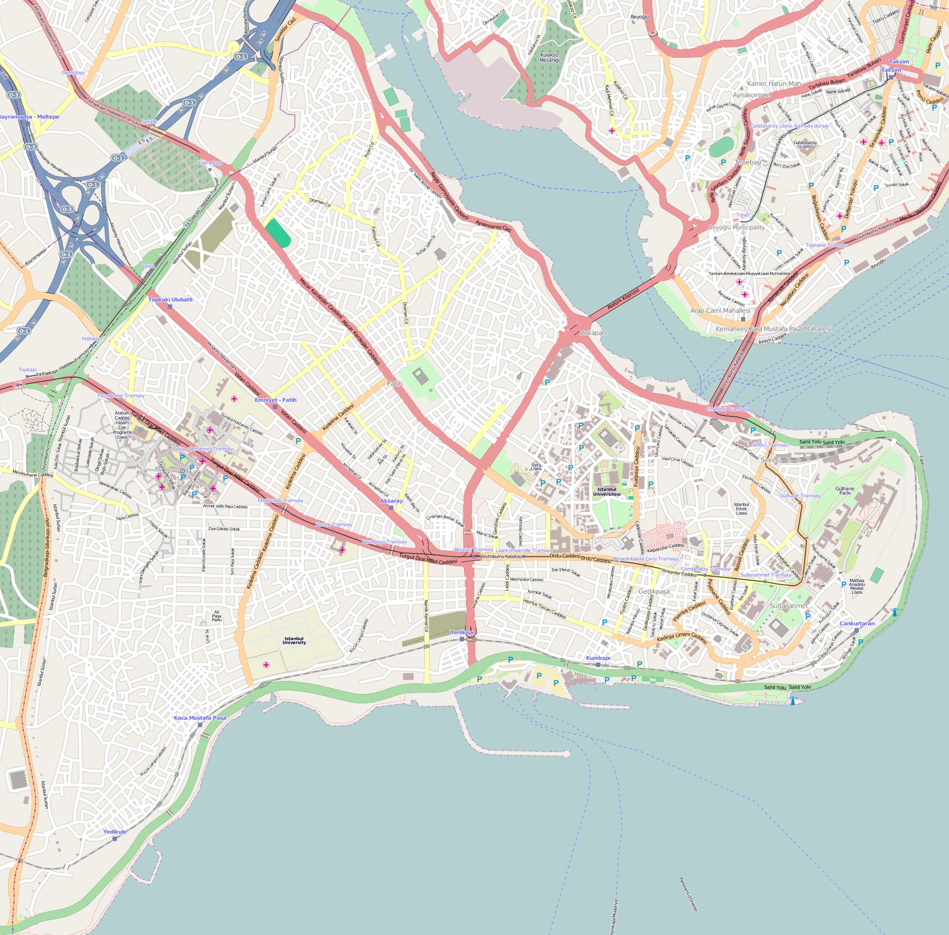
English: Location map of Fatih district of Istanbul. Borders coordinates:
N: 41.0411 W: 28.9181 E: 28.9895 S: 40.988 |
| நாள் | |
| மூலம் | http://www.openstreetmap.org |
| ஆசிரியர் | OpenStreetMap |
அனுமதி
- நீங்கள் சுதந்திரமாக:
- பகிர்ந்து கொள்ள – வேலையை நகலெடுக்க, விநியோகிக்க மற்றும் அனுப்ப
- மீண்டும் கலக்க – வேலைக்கு பழகிக்கொள்ள.
- கீழ்க்காணும் விதிகளுக்கு ஏற்ப,
- பண்புக்கூறுகள் – நீங்கள் பொருத்தமான உரிமையை வழங்க வேண்டும், உரிமத்திற்கான இணைப்பை வழங்க வேண்டும் மற்றும் மாற்றங்கள் செய்யப்பட்டிருந்தால் குறிப்பிட வேண்டும். நீங்கள் ஏற்புடைய எந்த முறையிலும் அவ்வாறு செய்யலாம், ஆனால் எந்த வகையிலும் உரிமதாரர் உங்களை அல்லது உங்கள் பயன்பாட்டிற்கு ஒப்புதல் அளிக்கும் படி பரிந்துரைக்க கூடாது.
- அதே மாதிரி பகிர் – நீங்கள் ரீமிக்ஸ் செய்தாலோ, உருமாற்றம் செய்தாலோ அல்லது பொருளை உருவாக்கினாலோ, உங்கள் பங்களிப்புகளை அல்லது இணக்கமான உரிமம் கீழ் அசலாக விநியோகிக்க வேண்டும்.
| Description |
This map was created from OpenStreetMap project data, collected by the community. This map may be incomplete, and may contain errors. Don't rely solely on it for navigation. |
|||
| நாள் | (see file history) | |||
| மூலம் | openstreetmap.org | |||
| படைப்பாளி |
OpenStreetMap contributors |
|||
| அனுமதி (இக்கோப்பை மீண்டும் பயன்படுத்துதல்) |
OpenStreetMap data is available under the Open Database License (details). Map tiles are licensed under the Creative Commons Attribution-ShareAlike 2.0 license (CC-BY-SA 2.0).
This file is licensed under the Creative Commons Attribution-Share Alike 2.0 Generic license.
|
|||
| Georeferencing | If inappropriate please set warp_status = skip to hide. |
கோப்பின் வரலாறு
குறித்த நேரத்தில் இருந்த படிமத்தைப் பார்க்க அந்நேரத்தின் மீது சொடுக்கவும்.
| நாள்/நேரம் | நகம் அளவு சிறுபடம் | அளவுகள் | பயனர் | கருத்து | |
|---|---|---|---|---|---|
| தற்போதைய | 17:06, 11 சூலை 2020 | | 1,957 × 1,929 (822 KB) | Nick | Reverted to version as of 17:05, 11 July 2020 (UTC) |
| 17:06, 11 சூலை 2020 | சிறுதோற்றம் இல்லை | 300 × 168 (14 KB) | Darren-M | Reverted to version as of 17:04, 11 July 2020 (UTC) | |
| 17:05, 11 சூலை 2020 |  | 1,957 × 1,929 (822 KB) | Mdaniels5757 | Reverted to version as of 17:04, 11 July 2020 (UTC) | |
| 17:04, 11 சூலை 2020 | சிறுதோற்றம் இல்லை | 300 × 168 (14 KB) | EvanHumphrey12 | Reverted to version as of 17:04, 11 July 2020 (UTC) | |
| 17:04, 11 சூலை 2020 |  | 1,957 × 1,929 (822 KB) | Mdaniels5757 | Reverted to version as of 17:04, 11 July 2020 (UTC) | |
| 17:04, 11 சூலை 2020 | சிறுதோற்றம் இல்லை | 300 × 168 (14 KB) | EvanHumphrey12 | Reverted to version as of 17:03, 11 July 2020 (UTC) | |
| 17:04, 11 சூலை 2020 |  | 1,957 × 1,929 (822 KB) | Mdaniels5757 | Reverted to version as of 17:03, 11 July 2020 (UTC) | |
| 17:03, 11 சூலை 2020 | சிறுதோற்றம் இல்லை | 300 × 168 (14 KB) | EvanHumphrey12 | Reverted to version as of 17:02, 11 July 2020 (UTC) | |
| 17:03, 11 சூலை 2020 |  | 1,957 × 1,929 (822 KB) | Mdaniels5757 | Reverted to version as of 17:02, 11 July 2020 (UTC) | |
| 17:02, 11 சூலை 2020 | சிறுதோற்றம் இல்லை | 300 × 168 (14 KB) | EvanHumphrey12 | Reverted to version as of 17:01, 11 July 2020 (UTC) |
கோப்பு பயன்பாடு
பின்வரும் பக்க இணைப்புகள் இப் படிமத்துக்கு இணைக்கபட்டுள்ளது(ளன):
கோப்பின் முழுமையான பயன்பாடு
கீழ்கண்ட மற்ற விக்கிகள் இந்த கோப்பை பயன்படுத்துகின்றன:
- bg.wikipedia.org-திட்டத்தில் இதன் பயன்பாடு
- bn.wikipedia.org-திட்டத்தில் இதன் பயன்பாடு
- cs.wikipedia.org-திட்டத்தில் இதன் பயன்பாடு
- en.wikipedia.org-திட்டத்தில் இதன் பயன்பாடு
- Fener
- Süleymaniye Mosque
- Bulgarian St. Stephen Church
- Basilica Cistern
- Rüstem Pasha Mosque
- Arap Mosque
- Bayezid II Mosque, Istanbul
- Boukoleon Palace
- Hagia Irene
- The Chora
- Fatih Mosque, Istanbul
- Zeynep Sultan Mosque
- New Mosque, Istanbul
- Column of Marcian
- St. George's Cathedral, Istanbul
- Little Hagia Sophia
- Zeyrek Mosque
- Laleli Mosque
- Fenari Isa Mosque
- Church of St. Anthony of Padua, Istanbul
- Pammakaristos Church
- Ahrida Synagogue of Istanbul
- Kalenderhane Mosque
- Gül Mosque
- Bodrum Mosque
- Yedikule Fortress
- Eski Imaret Mosque
- Church-Mosque of Vefa
- Kefeli Mosque
- Şehzade Mosque
- Sulukule
- Church of Saint Mary of the Mongols
- Hirami Ahmet Pasha Mosque
- Çarşamba, Fatih
- Ayakapı
- Koca Mustafa Pasha Mosque
- Atik Mustafa Pasha Mosque
- Pertevniyal Valide Sultan Mosque
- Vefa
- Theodosius Cistern
- Cistern of Philoxenos
- Sancaktar Hayrettin Mosque
- Church of St. Mary of Blachernae
சிறப்பு பக்கம்-மொத்த பயன்பாடு - இதன் மூலம் இந்த கோப்பின் மொத்த பயன்பாட்டை அறிய முடியும்