
படிமம்:LA2-Bering-Sea-UTM-zones.png

இந்த முன்னோட்டத்தின் அளவு: 800 × 430 படப்புள்ளிகள் . மற்ற பிரிதிறன்கள்: 320 × 172 படப்புள்ளிகள் | 640 × 344 படப்புள்ளிகள் | 960 × 516 படப்புள்ளிகள் .
மூலக்கோப்பு (960 × 516 படவணுக்கள், கோப்பின் அளவு: 103 KB, MIME வகை: image/png)
| இது விக்கிமீடியா பொதுக்கோப்பகத்தில் இருக்கும் ஒரு கோப்பாகும். இக்கோப்பைக் குறித்து அங்கே காணப்படும் படிம விளக்கப் பக்கத்தை இங்கே கீழே காணலாம்.
|
சுருக்கம்
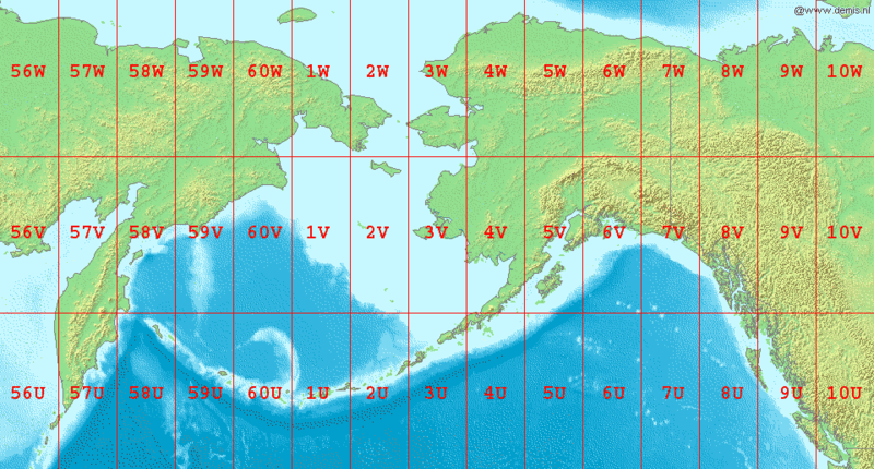
English: Map of en:Bering Sea, showing the latitude and longitude zones of the en:Universal Transverse Mercator coordinate system, from 56U to 10W.
National borders between Alaska, Canada, and the continental United States are also shown.
Bounding box West 150°, South 48°, East -120°, North 72°.
Center at 60°00′00″N 165°00′00″W / 60.00000°N 165.00000°W.
அனுமதி
This image is in the public domain because it came from the site https://www.demis.nl/products/web-map-server/examples/ and was released by the copyright holder. Permission is granted to copy, distribute and/or modify this map since it is based on free of copyright images from: www.demis.nl. See also approval email on de.wp and its clarification.
|
| This work has been released into the public domain by its copyright holder, www.demis.nl. This applies worldwide. சில நாடுகளில் இது சாத்தியமில்லாது போகலாம். அவ்வாறாயின் : www.demis.nl grants anyone the right to use this work for any purpose, without any conditions, unless such conditions are required by law.
|
கோப்பின் வரலாறு
குறித்த நேரத்தில் இருந்த படிமத்தைப் பார்க்க அந்நேரத்தின் மீது சொடுக்கவும்.
| நாள்/நேரம் | நகம் அளவு சிறுபடம் | அளவுகள் | பயனர் | கருத்து | |
|---|---|---|---|---|---|
| தற்போதைய | 07:04, 3 செப்டெம்பர் 2006 | | 960 × 516 (103 KB) | LA2 | Map of en:Bering Sea, showing the latitude and longitude zones of the en:Universal Transverse Mercator coordinate system, from 56U to 10W. National borders between Alaska, Canada, and the continental United States are also shown. Bounding box W |
கோப்பு பயன்பாடு
பின்வரும் பக்க இணைப்புகள் இப் படிமத்துக்கு இணைக்கபட்டுள்ளது(ளன):
கோப்பின் முழுமையான பயன்பாடு
கீழ்கண்ட மற்ற விக்கிகள் இந்த கோப்பை பயன்படுத்துகின்றன:
- ar.wikipedia.org-திட்டத்தில் இதன் பயன்பாடு
- ast.wikipedia.org-திட்டத்தில் இதன் பயன்பாடு
- da.wikipedia.org-திட்டத்தில் இதன் பயன்பாடு
- el.wikipedia.org-திட்டத்தில் இதன் பயன்பாடு
- en.wikipedia.org-திட்டத்தில் இதன் பயன்பாடு
- es.wikipedia.org-திட்டத்தில் இதன் பயன்பாடு
- fa.wikipedia.org-திட்டத்தில் இதன் பயன்பாடு
- gv.wikipedia.org-திட்டத்தில் இதன் பயன்பாடு
- hr.wikipedia.org-திட்டத்தில் இதன் பயன்பாடு
- hu.wikipedia.org-திட்டத்தில் இதன் பயன்பாடு
- id.wikipedia.org-திட்டத்தில் இதன் பயன்பாடு
- it.wikipedia.org-திட்டத்தில் இதன் பயன்பாடு
- kk.wikipedia.org-திட்டத்தில் இதன் பயன்பாடு
- la.wikipedia.org-திட்டத்தில் இதன் பயன்பாடு
- ml.wikipedia.org-திட்டத்தில் இதன் பயன்பாடு
- my.wikipedia.org-திட்டத்தில் இதன் பயன்பாடு
- nl.wikipedia.org-திட்டத்தில் இதன் பயன்பாடு
- nn.wikipedia.org-திட்டத்தில் இதன் பயன்பாடு
- pa.wikipedia.org-திட்டத்தில் இதன் பயன்பாடு
- pl.wikipedia.org-திட்டத்தில் இதன் பயன்பாடு
- sr.wikipedia.org-திட்டத்தில் இதன் பயன்பாடு
- th.wikipedia.org-திட்டத்தில் இதன் பயன்பாடு
- tr.wikipedia.org-திட்டத்தில் இதன் பயன்பாடு
- ur.wikipedia.org-திட்டத்தில் இதன் பயன்பாடு
- yi.wikipedia.org-திட்டத்தில் இதன் பயன்பாடு