
படிமம்:Kurdish-inhabited areas of the Middle East and the Soviet Union in 1986.jpg

இந்த முன்னோட்டத்தின் அளவு: 748 × 600 படப்புள்ளிகள் . மற்ற பிரிதிறன்கள்: 299 × 240 படப்புள்ளிகள் | 599 × 480 படப்புள்ளிகள் | 958 × 768 படப்புள்ளிகள் | 1,190 × 954 படப்புள்ளிகள் .
மூலக்கோப்பு (1,190 × 954 படவணுக்கள், கோப்பின் அளவு: 288 KB, MIME வகை: image/jpeg)
| இது விக்கிமீடியா பொதுக்கோப்பகத்தில் இருக்கும் ஒரு கோப்பாகும். இக்கோப்பைக் குறித்து அங்கே காணப்படும் படிம விளக்கப் பக்கத்தை இங்கே கீழே காணலாம்.
|
சுருக்கம்
| விளக்கம் |
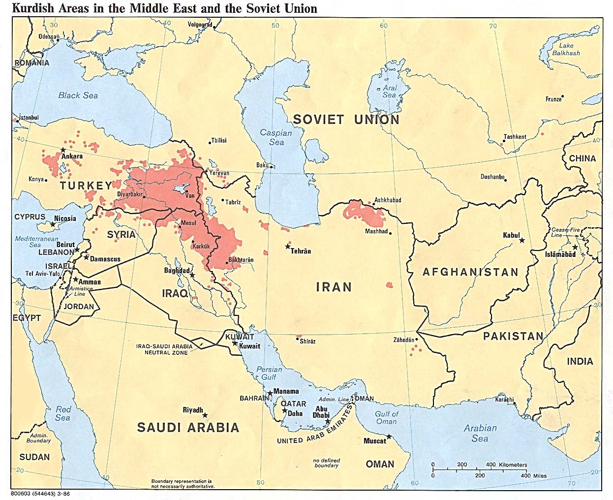
English: Kurdish-inhabited areas of the Middle East and the Soviet Union in 1986 |
| நாள் | |
| மூலம் | 800603 (544643) 3-86 |
| ஆசிரியர் | U.S. Central Intelligence Agency |
| அனுமதி (இக்கோப்பை மீண்டும் பயன்படுத்துதல்) |
See the list of maps at http://www.lib.utexas.edu/maps/iraq.html for a link to this map and related maps. That page says: "The following maps were produced by the U.S. Central Intelligence Agency, unless otherwise indicated." This particular map is labeled there as "Kurdish Areas in the Middle East and the Soviet Union. 1986." |
| ஒத்தக்கோப்பு | File:Kurdish language.jpg |
அனுமதி
| This image is a work of a Central Intelligence Agency employee, taken or made as part of that person's official duties. As a Work of the United States Government, this image or media is in the public domain in the United States.
|

|
கோப்பின் வரலாறு
குறித்த நேரத்தில் இருந்த படிமத்தைப் பார்க்க அந்நேரத்தின் மீது சொடுக்கவும்.
| நாள்/நேரம் | நகம் அளவு சிறுபடம் | அளவுகள் | பயனர் | கருத்து | |
|---|---|---|---|---|---|
| தற்போதைய | 15:32, 27 சூலை 2022 | | 1,190 × 954 (288 KB) | Eidiporia2 | The user vandalized a historical map |
| 11:12, 15 சூலை 2022 |  | 1,190 × 954 (232 KB) | Vajd | Reverted to version as of 20:56, 19 August 2010 (UTC) | |
| 16:48, 3 மார்ச்சு 2013 |  | 1,190 × 954 (288 KB) | Takabeg | Reverted to version as of 18:52, 16 September 2011 Ojanfar | |
| 19:19, 3 சனவரி 2013 |  | 1,190 × 954 (415 KB) | Ojanfar | corrector in south of the areas. | |
| 18:52, 16 செப்டெம்பர் 2011 |  | 1,190 × 954 (288 KB) | Kathovo | Reverted to version as of 15:17, 17 July 2010 | |
| 20:56, 19 ஆகத்து 2010 |  | 1,190 × 954 (232 KB) | Saadwand | Reverted to version as of 13:40, 4 July 2010 | |
| 15:17, 17 சூலை 2010 |  | 1,190 × 954 (288 KB) | Persia2099 | Reverted to version as of 11:33, 30 September 2005 | |
| 13:40, 4 சூலை 2010 |  | 1,190 × 954 (232 KB) | Saadwand | minor. | |
| 21:29, 17 சூன் 2010 |  | 1,190 × 954 (229 KB) | Saadwand | minor: Distribution of Kurds | |
| 22:59, 8 சூன் 2010 |  | 1,190 × 954 (230 KB) | Saadwand | (new version) |
கோப்பு பயன்பாடு
பின்வரும் பக்க இணைப்புகள் இப் படிமத்துக்கு இணைக்கபட்டுள்ளது(ளன):
கோப்பின் முழுமையான பயன்பாடு
கீழ்கண்ட மற்ற விக்கிகள் இந்த கோப்பை பயன்படுத்துகின்றன:
- af.wikipedia.org-திட்டத்தில் இதன் பயன்பாடு
- ast.wikipedia.org-திட்டத்தில் இதன் பயன்பாடு
- az.wikipedia.org-திட்டத்தில் இதன் பயன்பாடு
- be-tarask.wikipedia.org-திட்டத்தில் இதன் பயன்பாடு
- be.wikipedia.org-திட்டத்தில் இதன் பயன்பாடு
- bg.wikipedia.org-திட்டத்தில் இதன் பயன்பாடு
- ca.wikipedia.org-திட்டத்தில் இதன் பயன்பாடு
- en.wikipedia.org-திட்டத்தில் இதன் பயன்பாடு
- eo.wikipedia.org-திட்டத்தில் இதன் பயன்பாடு
- es.wikipedia.org-திட்டத்தில் இதன் பயன்பாடு
- eu.wikipedia.org-திட்டத்தில் இதன் பயன்பாடு
- fi.wikipedia.org-திட்டத்தில் இதன் பயன்பாடு
- fr.wikipedia.org-திட்டத்தில் இதன் பயன்பாடு
- he.wikipedia.org-திட்டத்தில் இதன் பயன்பாடு
- is.wikipedia.org-திட்டத்தில் இதன் பயன்பாடு
- kab.wikipedia.org-திட்டத்தில் இதன் பயன்பாடு
- ku.wikipedia.org-திட்டத்தில் இதன் பயன்பாடு
- kv.wikipedia.org-திட்டத்தில் இதன் பயன்பாடு
- lt.wikipedia.org-திட்டத்தில் இதன் பயன்பாடு
- mk.wikipedia.org-திட்டத்தில் இதன் பயன்பாடு
- nn.wikipedia.org-திட்டத்தில் இதன் பயன்பாடு
- oc.wikipedia.org-திட்டத்தில் இதன் பயன்பாடு
- pl.wikipedia.org-திட்டத்தில் இதன் பயன்பாடு
- pl.wikinews.org-திட்டத்தில் இதன் பயன்பாடு
- pl.wikiquote.org-திட்டத்தில் இதன் பயன்பாடு
- scn.wikipedia.org-திட்டத்தில் இதன் பயன்பாடு
- tr.wikipedia.org-திட்டத்தில் இதன் பயன்பாடு
- tt.wikipedia.org-திட்டத்தில் இதன் பயன்பாடு
- uk.wikipedia.org-திட்டத்தில் இதன் பயன்பாடு