
படிமம்:Greater Jerusalem May 2006 CIA remote-sensing map 3500px.jpg

இந்த முன்னோட்டத்தின் அளவு: 463 × 599 படப்புள்ளிகள் . மற்ற பிரிதிறன்கள்: 185 × 240 படப்புள்ளிகள் | 371 × 480 படப்புள்ளிகள் | 593 × 768 படப்புள்ளிகள் | 791 × 1,024 படப்புள்ளிகள் | 1,582 × 2,048 படப்புள்ளிகள் | 3,500 × 4,530 படப்புள்ளிகள் .
மூலக்கோப்பு (3,500 × 4,530 படவணுக்கள், கோப்பின் அளவு: 5.54 MB, MIME வகை: image/jpeg)
| இது விக்கிமீடியா பொதுக்கோப்பகத்தில் இருக்கும் ஒரு கோப்பாகும். இக்கோப்பைக் குறித்து அங்கே காணப்படும் படிம விளக்கப் பக்கத்தை இங்கே கீழே காணலாம்.
|
Note: This is a smaller 3500-pixel-wide version of the original map. The original map on the Commons is 8,264 × 10,696 pixels and has a huge file size of 53.3 MB. This 3500-pixel-wide version of the map is 5.54 MB. A warning on the page for the larger image: {{LargeImage}}
| விளக்கம் |
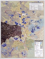
English: Greater Jerusalem, May 2006. United States. Central Intelligence Agency. CREATED/PUBLISHED [Washington, D.C.] : Central Intelligence Agency, [2006] NOTES Shows settlements, refugee camps, fences, walls, etc. "Imagery base: SPOT 5 multispectral imagery acquired July 2004." Includes chart describing plans for new settlements. "803197AI (G00307) 5-06." Scale 1:40,000 ; universal transverse Mercator proj. (E 35006'--E 35021'/N 31054'--N 310390). MEDIUM 1 remote-sensing map : col. ; 87 x 67 cm. CALL NUMBER G7504.J4G4 2006 .U5 REPOSITORY Library of Congress Geography and Map Division Washington, D.C. 20540-4650 USA DIGITAL ID g7504j ct001915 http://hdl.loc.gov/loc.gmd/g7504j.ct001915 Note:Image converted from jp2 -> jpg |
| நாள் | (UTC) |
| மூலம் | This is a 3500-pixel-wide version of the above-linked original map that is 8,264 × 10,696 pixels, with a file size of 53.3 MB. This 3500-pixel-wide version is 5.54 MB. |
| ஆசிரியர் |
|
| ஒத்தக்கோப்பு |
.jpg)
| This work is from the Library of Congress. According to the library, there are no known copyright restrictions on the use of this work. |  |
Original upload log
This image is a derivative work of the following images:
- File:Greater_Jerusalem_May_2006_CIA_remote-sensing_map_.jpg licensed with PD-USGov
- 2010-04-24T11:10:11Z Sean.hoyland 8264x10696 (55888328 Bytes) {{Information |Description={{en|1=Greater Jerusalem, May 2006. United States. Central Intelligence Agency. CREATED/PUBLISHED [Washington, D.C.] : Central Intelligence Agency, [2006] NOTES Shows settlements, refugee camps, fe
Uploaded with derivativeFX
கோப்பின் வரலாறு
குறித்த நேரத்தில் இருந்த படிமத்தைப் பார்க்க அந்நேரத்தின் மீது சொடுக்கவும்.
| நாள்/நேரம் | நகம் அளவு சிறுபடம் | அளவுகள் | பயனர் | கருத்து | |
|---|---|---|---|---|---|
| தற்போதைய | 06:15, 3 அக்டோபர் 2010 | | 3,500 × 4,530 (5.54 MB) | Timeshifter | {{Information |Description={{en|1=Greater Jerusalem, May 2006. United States. Central Intelligence Agency.<br> CREATED/PUBLISHED<br> [Washington, D.C.] : Central Intelligence Agency, [2006]<br> NOTES<br> Shows settlements, refugee camps, fences, walls, e |
கோப்பு பயன்பாடு
பின்வரும் பக்க இணைப்புகள் இப் படிமத்துக்கு இணைக்கபட்டுள்ளது(ளன):
கோப்பின் முழுமையான பயன்பாடு
கீழ்கண்ட மற்ற விக்கிகள் இந்த கோப்பை பயன்படுத்துகின்றன:
- ar.wikipedia.org-திட்டத்தில் இதன் பயன்பாடு
- arz.wikipedia.org-திட்டத்தில் இதன் பயன்பாடு
- azb.wikipedia.org-திட்டத்தில் இதன் பயன்பாடு
- de.wikipedia.org-திட்டத்தில் இதன் பயன்பாடு
- en.wikipedia.org-திட்டத்தில் இதன் பயன்பாடு
- eo.wikipedia.org-திட்டத்தில் இதன் பயன்பாடு
- es.wikipedia.org-திட்டத்தில் இதன் பயன்பாடு
- id.wikipedia.org-திட்டத்தில் இதன் பயன்பாடு
- ja.wikipedia.org-திட்டத்தில் இதன் பயன்பாடு
- nn.wikipedia.org-திட்டத்தில் இதன் பயன்பாடு
- no.wikipedia.org-திட்டத்தில் இதன் பயன்பாடு
- or.wikipedia.org-திட்டத்தில் இதன் பயன்பாடு
- pt.wikipedia.org-திட்டத்தில் இதன் பயன்பாடு
- ru.wikipedia.org-திட்டத்தில் இதன் பயன்பாடு
- sl.wikipedia.org-திட்டத்தில் இதன் பயன்பாடு
- tl.wikipedia.org-திட்டத்தில் இதன் பயன்பாடு
- tr.wikipedia.org-திட்டத்தில் இதன் பயன்பாடு
- zh.wikipedia.org-திட்டத்தில் இதன் பயன்பாடு