
படிமம்:France colonial Empire10.png
இந்த முன்னோட்டத்தின் அளவு: 800 × 370 படப்புள்ளிகள் . மற்ற பிரிதிறன்கள்: 320 × 148 படப்புள்ளிகள் | 640 × 296 படப்புள்ளிகள் | 1,357 × 628 படப்புள்ளிகள் .
மூலக்கோப்பு (1,357 × 628 படவணுக்கள், கோப்பின் அளவு: 43 KB, MIME வகை: image/png)
| இது விக்கிமீடியா பொதுக்கோப்பகத்தில் இருக்கும் ஒரு கோப்பாகும். இக்கோப்பைக் குறித்து அங்கே காணப்படும் படிம விளக்கப் பக்கத்தை இங்கே கீழே காணலாம்.
|
சுருக்கம்
From en:Image:France colonial Empire10.png List of internet sources (to complete) :
- http://www.tu-dresden.de/sulcifra/quebec/geschqu/paris.htm
- http://homepages.rootsweb.com/~poyntz/India/images/india_shepherd_1923.jpg
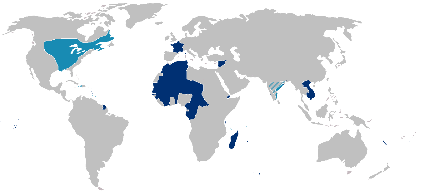
Map of the first (light blue) and second (dark blue) French colonial empires. Hatched portions mark spheres of French influence rather than possessions.
Note that the state of France's actual control over much of interior North America west and south of Great Lakes was almost purely nominal.
அனுமதி
| இந்த கோப்பு Creative Commons Attribution-Share Alike 3.0 Unported உரிமத்தின் கீழ் உள்ளது. Subject to disclaimers. | ||
| ||
| This licensing tag was added to this file as part of the GFDL licensing update. |

|
GNU Free Documentation License விதிமுறைகளின் கீழ் இந்த ஆவணத்தை நகலெடுக்க, விநியோகிக்க மற்றும்/அல்லது மாற்றுவதற்கு அனுமதி வழங்கப்பட்டுள்ளது, Free Software Foundation;ஆல் வெளியிடப்பட்ட பதிப்பு 1.2 அல்லது அதற்குப் பிந்தைய பதிப்பு, மாற்றமில்லாத பிரிவுகள், முன் அட்டை உரைகள் மற்றும் பின் அட்டை உரைகள் இல்லாமல் வெளியிடப்பட்டது. GNU Free Documentation License என்ற தலைப்பில் உரிமத்தின் நகல் சேர்க்கப்பட்டுள்ளது. Subject to disclaimers. |
Other versions

|
This historical map image could be re-created using vector graphics as an SVG file. This has several advantages; see Commons:Media for cleanup for more information. If an SVG form of this image is available, please upload it and afterwards replace this template with
{{vector version available|new image name}}.
It is recommended to name the SVG file “France colonial Empire10.svg”—then the template Vector version available (or Vva) does not need the new image name parameter. |
கோப்பின் வரலாறு
குறித்த நேரத்தில் இருந்த படிமத்தைப் பார்க்க அந்நேரத்தின் மீது சொடுக்கவும்.
| நாள்/நேரம் | நகம் அளவு சிறுபடம் | அளவுகள் | பயனர் | கருத்து | |
|---|---|---|---|---|---|
| தற்போதைய | 16:43, 3 மார்ச்சு 2019 | | 1,357 × 628 (43 KB) | Rzzgn | Corrections |
| 23:43, 9 ஆகத்து 2011 |  | 1,357 × 628 (15 KB) | Omar-Toons | corr. oversizing | |
| 17:10, 8 ஆகத்து 2011 |  | 1,357 × 628 (14 KB) | Bokpasa | Tarfaya and Ifni, was part of Spain, not France | |
| 23:07, 13 சூன் 2010 |  | 1,357 × 628 (11 KB) | Jahoe | compressed using pngout | |
| 15:29, 31 மே 2010 |  | 1,357 × 628 (45 KB) | Max96 | Evened out the striping | |
| 19:14, 6 சனவரி 2009 |  | 1,357 × 628 (31 KB) | Kmusser | Reverted to version as of 20:52, 19 March 2007 | |
| 23:30, 31 திசம்பர் 2008 |  | 1,357 × 628 (26 KB) | The Red Hat of Pat Ferrick | Corrections. | |
| 20:52, 19 மார்ச்சு 2007 |  | 1,357 × 628 (31 KB) | Kmusser | Changed portion of India, Siam to hatched, exaggerated and added some islands. | |
| 16:17, 14 அக்டோபர் 2005 |  | 1,357 × 628 (24 KB) | Yug | From en:Image:France colonial Empire10.png |
கோப்பு பயன்பாடு
பின்வரும் பக்க இணைப்புகள் இப் படிமத்துக்கு இணைக்கபட்டுள்ளது(ளன):
கோப்பின் முழுமையான பயன்பாடு
கீழ்கண்ட மற்ற விக்கிகள் இந்த கோப்பை பயன்படுத்துகின்றன:
- azb.wikipedia.org-திட்டத்தில் இதன் பயன்பாடு
- en.wikipedia.org-திட்டத்தில் இதன் பயன்பாடு
- eo.wikipedia.org-திட்டத்தில் இதன் பயன்பாடு
- fa.wikipedia.org-திட்டத்தில் இதன் பயன்பாடு
- fr.wikipedia.org-திட்டத்தில் இதன் பயன்பாடு
- Politique extérieure française de 1814 à 1914
- Discussion utilisateur:Reynier
- Projet:Nouvelle-France/Brasserie Port-Royal/Archives 2
- Wikipédia:Atelier graphique/Cartes/Archives/décembre 2007
- Dates des indépendances dans l'empire colonial français
- Histoire de France
- Projet:Nouvelle-France/Brasserie Port-Royal/Archives
- ku.wikipedia.org-திட்டத்தில் இதன் பயன்பாடு
- mg.wikipedia.org-திட்டத்தில் இதன் பயன்பாடு
- mk.wikipedia.org-திட்டத்தில் இதன் பயன்பாடு
- pt.wikipedia.org-திட்டத்தில் இதன் பயன்பாடு
- sr.wikipedia.org-திட்டத்தில் இதன் பயன்பாடு
- ug.wikipedia.org-திட்டத்தில் இதன் பயன்பாடு
- zh-yue.wikipedia.org-திட்டத்தில் இதன் பயன்பாடு