
படிமம்:Egypt and neighbors 1880 map de.png
இந்த முன்னோட்டத்தின் அளவு: 606 × 600 படப்புள்ளிகள் . மற்ற பிரிதிறன்கள்: 243 × 240 படப்புள்ளிகள் | 485 × 480 படப்புள்ளிகள் | 776 × 768 படப்புள்ளிகள் | 1,035 × 1,024 படப்புள்ளிகள் | 2,122 × 2,100 படப்புள்ளிகள் .
மூலக்கோப்பு (2,122 × 2,100 படவணுக்கள், கோப்பின் அளவு: 896 KB, MIME வகை: image/png)
| இது விக்கிமீடியா பொதுக்கோப்பகத்தில் இருக்கும் ஒரு கோப்பாகும். இக்கோப்பைக் குறித்து அங்கே காணப்படும் படிம விளக்கப் பக்கத்தை இங்கே கீழே காணலாம்.
|
சுருக்கம்
| விளக்கம் |
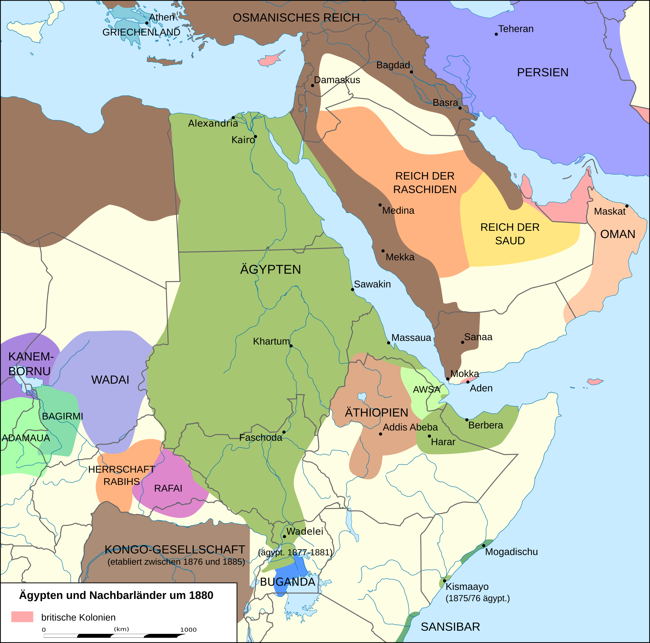
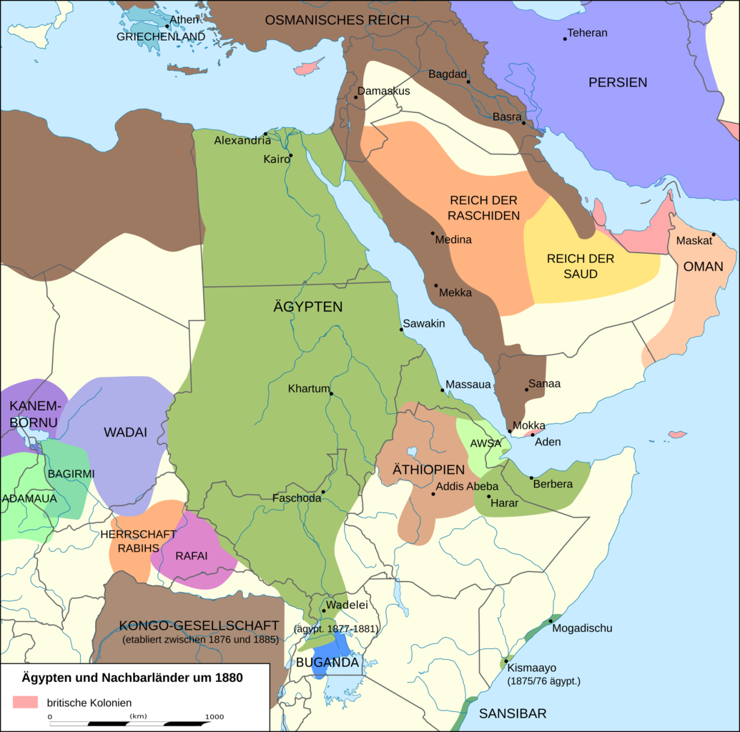
English: Map of Egypt and its neighbors 1880 in German.
Deutsch: Karte Ägyptens und seiner Nachbarn 1880.
Quellen:
|
| நாள் | |
| மூலம் | சொந்த முயற்சி, derivate of File:Africa location map.svg |
| ஆசிரியர் | Don-kun, Eric Gaba (Sting - fr:Sting) |
| ஒத்தக்கோப்பு |
 |
.png)
அனுமதி
இந்த ஆக்கத்தின் காப்புரிமையாளரான நான் இதனைப் பின்வரும் உரிமத்தின் கீழ் வெளியிடுகின்றேன்:

|
GNU Free Documentation License விதிமுறைகளின் கீழ் இந்த ஆவணத்தை நகலெடுக்க, விநியோகிக்க மற்றும்/அல்லது மாற்றுவதற்கு அனுமதி வழங்கப்பட்டுள்ளது, Free Software Foundation;ஆல் வெளியிடப்பட்ட பதிப்பு 1.2 அல்லது அதற்குப் பிந்தைய பதிப்பு, மாற்றமில்லாத பிரிவுகள், முன் அட்டை உரைகள் மற்றும் பின் அட்டை உரைகள் இல்லாமல் வெளியிடப்பட்டது. GNU Free Documentation License என்ற தலைப்பில் உரிமத்தின் நகல் சேர்க்கப்பட்டுள்ளது. |
This file is licensed under the Creative Commons Attribution 3.0 Unported license.
- நீங்கள் சுதந்திரமாக:
- பகிர்ந்து கொள்ள – வேலையை நகலெடுக்க, விநியோகிக்க மற்றும் அனுப்ப
- மீண்டும் கலக்க – வேலைக்கு பழகிக்கொள்ள.
- கீழ்க்காணும் விதிகளுக்கு ஏற்ப,
- பண்புக்கூறுகள் – நீங்கள் பொருத்தமான உரிமையை வழங்க வேண்டும், உரிமத்திற்கான இணைப்பை வழங்க வேண்டும் மற்றும் மாற்றங்கள் செய்யப்பட்டிருந்தால் குறிப்பிட வேண்டும். நீங்கள் ஏற்புடைய எந்த முறையிலும் அவ்வாறு செய்யலாம், ஆனால் எந்த வகையிலும் உரிமதாரர் உங்களை அல்லது உங்கள் பயன்பாட்டிற்கு ஒப்புதல் அளிக்கும் படி பரிந்துரைக்க கூடாது.
நீர் உமக்கு விருப்பமான உரிமத்தை தேர்ந்தெடுக்கலாம்.
கோப்பின் வரலாறு
குறித்த நேரத்தில் இருந்த படிமத்தைப் பார்க்க அந்நேரத்தின் மீது சொடுக்கவும்.
| நாள்/நேரம் | நகம் அளவு சிறுபடம் | அளவுகள் | பயனர் | கருத்து | |
|---|---|---|---|---|---|
| தற்போதைய | 20:39, 28 சனவரி 2016 | | 2,122 × 2,100 (896 KB) | Don-kun | see discussion and following sources |
| 16:34, 6 மே 2015 |  | 2,123 × 2,101 (843 KB) | Middayexpress | The area was indeed at the time controlled by Somali sultanates, not the Zanzibaris: https://commons.wikimedia.org/wiki/File:1867_Horn_of_Africa_map.jpg | |
| 04:58, 6 மே 2015 |  | 2,123 × 2,101 (840 KB) | Don-kun | you obviously didnt | |
| 17:15, 5 மே 2015 |  | 2,123 × 2,101 (843 KB) | Middayexpress | The area was controlled by Somali Sultanates. Those were the polities that the Italian colonial administration actually signed treaties with, not the Zanzibaris. Please see: https://en.wikipedia.org/wiki/Italian_Somaliland https://en.wikipedia.org/wi... | |
| 15:14, 5 மே 2015 |  | 2,123 × 2,101 (840 KB) | Don-kun | unless you can cite a source confirming the modern border of kenia for 1880 and so forth the map remins as before | |
| 19:03, 2 மே 2015 |  | 2,123 × 2,101 (843 KB) | Middayexpress | Zanzibari authority was indeed only nominal. The Geledi Sultanate actually resided in and ruled the area. | |
| 10:12, 1 மே 2015 |  | 2,123 × 2,101 (840 KB) | Don-kun | as stated before: Sansibarian garrison in Mogadishu since 1874 and insist on todays border for 1880 is just absurd | |
| 20:45, 30 ஏப்பிரல் 2015 |  | 2,123 × 2,101 (843 KB) | AcidSnow | They had no authority in Mogadishu, let alone any other Somali city. All power was in the hands of the Geledi Sultanate. | |
| 05:54, 24 பெப்பிரவரி 2015 |  | 2,123 × 2,101 (840 KB) | Don-kun | Reverted to version as of 21:59, 2 November 2011 Sansibarian garrison in Mogadishu since 1874, Kenian/Somalian border nonexistent in that time | |
| 22:17, 23 பெப்பிரவரி 2015 |  | 2,123 × 2,101 (843 KB) | AcidSnow | The Geledi controlled southern Somalia. |
கோப்பு பயன்பாடு
பின்வரும் பக்க இணைப்புகள் இப் படிமத்துக்கு இணைக்கபட்டுள்ளது(ளன):
கோப்பின் முழுமையான பயன்பாடு
கீழ்கண்ட மற்ற விக்கிகள் இந்த கோப்பை பயன்படுத்துகின்றன:
- azb.wikipedia.org-திட்டத்தில் இதன் பயன்பாடு
- de.wikipedia.org-திட்டத்தில் இதன் பயன்பாடு
- en.wikipedia.org-திட்டத்தில் இதன் பயன்பாடு
- fi.wikipedia.org-திட்டத்தில் இதன் பயன்பாடு
- fr.wikipedia.org-திட்டத்தில் இதன் பயன்பாடு
- it.wikipedia.org-திட்டத்தில் இதன் பயன்பாடு
- it.wikiquote.org-திட்டத்தில் இதன் பயன்பாடு
- ja.wikipedia.org-திட்டத்தில் இதன் பயன்பாடு
- ka.wikipedia.org-திட்டத்தில் இதன் பயன்பாடு
- uk.wikipedia.org-திட்டத்தில் இதன் பயன்பாடு