படிமம்:DojiBaraFamineInJoppen1907India1795a.jpg

மூலக்கோப்பு (828 × 1,200 படவணுக்கள், கோப்பின் அளவு: 209 KB, MIME வகை: image/jpeg)
| Description |
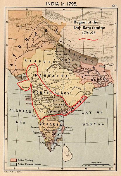
Doji bara famine shown on Map of India in 1795 from: Joppen, Charles [SJ.] (1907), A Historical Atlas of India for the use of High-Schools, Colleges, and Private Students, London, New York, Bombay, and Calcutta: Longman Green and Co. Pp. 16, 26 maps. Scanned from personal copy, famine region drawn, reduced, uploaded by Fowler&fowler«Talk» 06:04, 19 February 2011 (UTC) |
|---|---|
| Source |
(Fowler&fowler«Talk») created this work entirely by himself. |
| Date |
06:04, 19 February 2011 (UTC) (drawn on map made in 1907 |
| Author |
Fowler&fowler«Talk» (drawn on map by Justus Perthes, Gotha./Charles Joppen) |
| Permission (Reusing this file) |
See below.
|
| இந்த படைப்பானது, படைப்பாக்கப் பொதுமங்கள் Attribution-ShareAlike 3.0 என்ற உரிமத்தின் கீழ் அமைகிறது. Attribution: GFDL |
கோப்பின் வரலாறு
குறித்த நேரத்தில் இருந்த படிமத்தைப் பார்க்க அந்நேரத்தின் மீது சொடுக்கவும்.
| நாள்/நேரம் | நகம் அளவு சிறுபடம் | அளவுகள் | பயனர் | கருத்து | |
|---|---|---|---|---|---|
| தற்போதைய | 17:27, 6 மார்ச்சு 2012 |  | 828 × 1,200 (209 KB) | Sodabottle (பேச்சு | பங்களிப்புகள்) |
நீங்கள் இந்தக் கோப்பை மேலெழுத முடியாது.
கோப்பு பயன்பாடு
பின்வரும் பக்க இணைப்புகள் இப் படிமத்துக்கு இணைக்கபட்டுள்ளது(ளன):
