படிமம்:Districts of Libya Controlled by Gaddafi and the NTC.png

மற்ற மொழிகளில் ஆதரிக்கப்படாத பக்க உள்ளடக்கம்.
கட்டற்ற கலைக்களஞ்சியமான விக்கிப்பீடியாவில் இருந்து.

Districts_of_Libya_Controlled_by_Gaddafi_and_the_NTC.png(462 × 427 படவணுக்கள், கோப்பின் அளவு: 6 KB, MIME வகை: image/png)

இது விக்கிமீடியா பொதுக்கோப்பகத்தில் இருக்கும் ஒரு கோப்பாகும். இக்கோப்பைக் குறித்து அங்கே காணப்படும் படிம விளக்கப் பக்கத்தை இங்கே கீழே காணலாம்.
பொதுக்கோப்பகம் ஒரு கட்டற்ற கோப்புகளின் சேமிப்பகமாகும். நீங்களும் உதவலாம்.

சுருக்கம்

விளக்கம்
English:
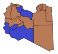
Blue: Districts which neither party has overall control.


Brown: Districts controlled by the National Transitional Council.


This map is based on 2011 Libyan uprising Wikipedia article map
நாள் First uploaded 29 March 2011
மூலம் சொந்த முயற்சி
ஆசிரியர் IJA
ஒத்தக்கோப்பு

[தொகு]

English: Maps of the whole country by language
English: Maps of a single area of the country
Sidra
Western Libya
Tripoli
Misrata
Sirte
English: Historical maps
Other maps

அனுமதி

இந்த ஆக்கத்தின் காப்புரிமையாளரான நான் இதனைப் பின்வரும் உரிமத்தின் கீழ் வெளியிடுகின்றேன்:
Creative Commons CC-Zero This file is made available under the Creative Commons CC0 1.0 Universal Public Domain Dedication.
The person who associated a work with this deed has dedicated the work to the public domain by waiving all of their rights to the work worldwide under copyright law, including all related and neighboring rights, to the extent allowed by law. You can copy, modify, distribute and perform the work, even for commercial purposes, all without asking permission.

Captions

Add a one-line explanation of what this file represents

some value

Wikimedia username ஆங்கிலம்: IJA
author name string ஆங்கிலம்: IJA

source of file ஆங்கிலம்

original creation by uploader ஆங்கிலம்

கோப்பின் வரலாறு

குறித்த நேரத்தில் இருந்த படிமத்தைப் பார்க்க அந்நேரத்தின் மீது சொடுக்கவும்.

(மிகப் புதிய | மிகப் பழைய) (புதிய 10 | ) (10 | 20 | 50 | 100 | 250 | 500) பக்கங்களைப் பார்.
நாள்/நேரம்நகம் அளவு சிறுபடம்அளவுகள்பயனர்கருத்து
தற்போதைய14:12, 20 அக்டோபர் 201114:12, 20 அக்டோபர் 2011 இலிருந்த பதிப்புக்கான சிறு தோற்றம்462 × 427 (6 KB)VectrexSirte fell, Gaddafi died
20:20, 18 அக்டோபர் 201120:20, 18 அக்டோபர் 2011 இலிருந்த பதிப்புக்கான சிறு தோற்றம்462 × 427 (5 KB)SpaceshuttlediscoveryBani Walid captured by the rebels.
15:39, 9 அக்டோபர் 201115:39, 9 அக்டோபர் 2011 இலிருந்த பதிப்புக்கான சிறு தோற்றம்462 × 427 (9 KB)VectrexGhat to NTC
11:55, 30 செப்டெம்பர் 201111:55, 30 செப்டெம்பர் 2011 இலிருந்த பதிப்புக்கான சிறு தோற்றம்462 × 427 (9 KB)Nightstallionfuqaha taken
15:13, 25 செப்டெம்பர் 201115:13, 25 செப்டெம்பர் 2011 இலிருந்த பதிப்புக்கான சிறு தோற்றம்462 × 427 (9 KB)VectrexQatrun appears to be liberated after all
11:19, 24 செப்டெம்பர் 201111:19, 24 செப்டெம்பர் 2011 இலிருந்த பதிப்புக்கான சிறு தோற்றம்462 × 427 (9 KB)VectrexUpdate
12:33, 23 செப்டெம்பர் 201112:33, 23 செப்டெம்பர் 2011 இலிருந்த பதிப்புக்கான சிறு தோற்றம்462 × 427 (8 KB)NightstallionFuqaha still under Qaddafi control
08:14, 22 செப்டெம்பர் 201108:14, 22 செப்டெம்பர் 2011 இலிருந்த பதிப்புக்கான சிறு தோற்றம்462 × 427 (8 KB)Nightstallionthis map seems about right
23:47, 21 செப்டெம்பர் 201123:47, 21 செப்டெம்பர் 2011 இலிருந்த பதிப்புக்கான சிறு தோற்றம்463 × 436 (5 KB)SpaceshuttlediscoverySabha under NTC control.
23:42, 21 செப்டெம்பர் 201123:42, 21 செப்டெம்பர் 2011 இலிருந்த பதிப்புக்கான சிறு தோற்றம்462 × 427 (8 KB)SpaceshuttlediscoverySabha liberated by the NTC on September 21
(மிகப் புதிய | மிகப் பழைய) (புதிய 10 | ) (10 | 20 | 50 | 100 | 250 | 500) பக்கங்களைப் பார்.

பின்வரும் பக்க இணைப்புகள் இப் படிமத்துக்கு இணைக்கபட்டுள்ளது(ளன):

கோப்பின் முழுமையான பயன்பாடு

கீழ்கண்ட மற்ற விக்கிகள் இந்த கோப்பை பயன்படுத்துகின்றன:

மேனிலைத் தரவு

"https://ta.wikipedia.org/wiki/படிமம்:Districts_of_Libya_Controlled_by_Gaddafi_and_the_NTC.png" இலிருந்து மீள்விக்கப்பட்டது