
படிமம்:China Xinjiang relief location map.jpg
மூலக்கோப்பு (2,220 × 1,939 படவணுக்கள், கோப்பின் அளவு: 1.38 MB, MIME வகை: image/jpeg)
| இது விக்கிமீடியா பொதுக்கோப்பகத்தில் இருக்கும் ஒரு கோப்பாகும். இக்கோப்பைக் குறித்து அங்கே காணப்படும் படிம விளக்கப் பக்கத்தை இங்கே கீழே காணலாம்.
|


|
This file requires updating because: The China-Tajikistan border has changed, the Kazakhstan-Russia border is inexplicably missing, Kunyu, Xinjiang is not included, etc. problems In doing so, you could add a timestamp to the file.
|
சுருக்கம்
| விளக்கம் |
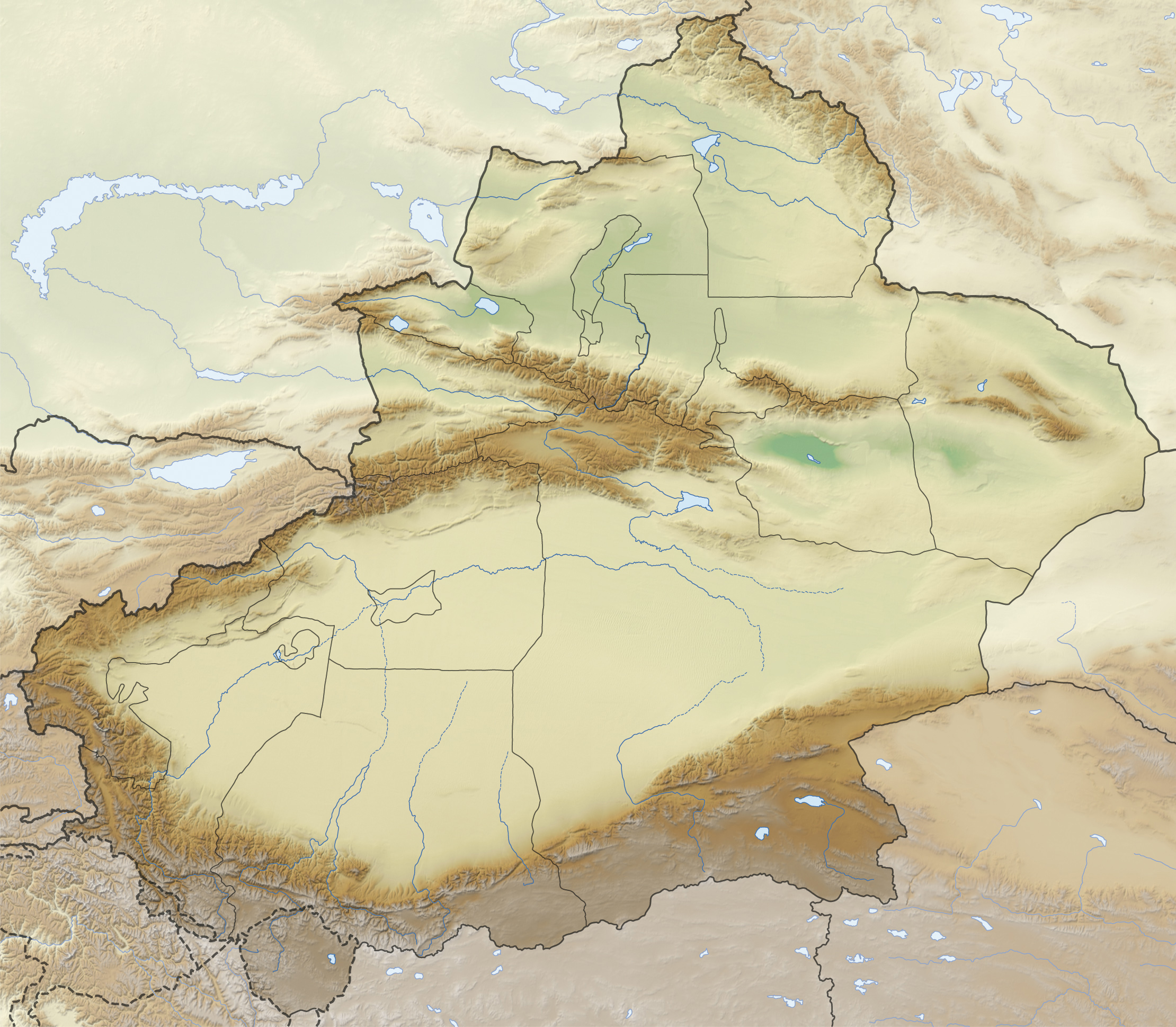
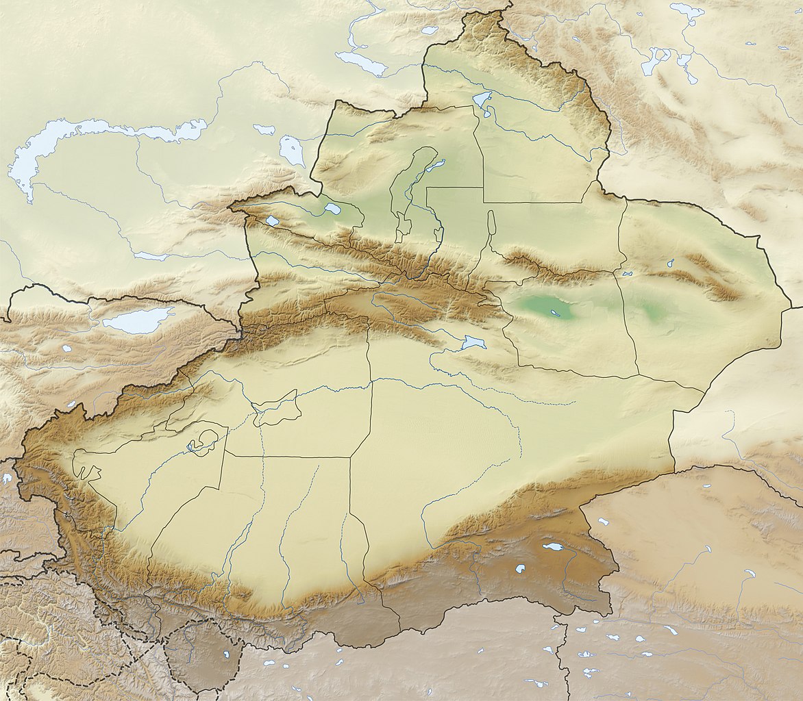
Quadratische Plattkarte, N-S-Streckung 135 %. Geographische Begrenzung der Karte:
Equirectangular projection, N/S stretching 135 %. Geographic limits of the map:
|
|
| நாள் | ||
| மூலம் |
சொந்த முயற்சி, using
|
|
| ஆசிரியர் | NordNordWest | |
| அனுமதி (இக்கோப்பை மீண்டும் பயன்படுத்துதல்) |
This file is licensed under the Creative Commons Attribution-Share Alike 3.0 Germany license.
 |
|
| ஒத்தக்கோப்பு |
|


|
This map has been made or improved in the German Kartenwerkstatt (Map Lab). You can propose maps to improve as well.
|
அனுமதி
- நீங்கள் சுதந்திரமாக:
- பகிர்ந்து கொள்ள – வேலையை நகலெடுக்க, விநியோகிக்க மற்றும் அனுப்ப
- மீண்டும் கலக்க – வேலைக்கு பழகிக்கொள்ள.
- கீழ்க்காணும் விதிகளுக்கு ஏற்ப,
- பண்புக்கூறுகள் – நீங்கள் பொருத்தமான உரிமையை வழங்க வேண்டும், உரிமத்திற்கான இணைப்பை வழங்க வேண்டும் மற்றும் மாற்றங்கள் செய்யப்பட்டிருந்தால் குறிப்பிட வேண்டும். நீங்கள் ஏற்புடைய எந்த முறையிலும் அவ்வாறு செய்யலாம், ஆனால் எந்த வகையிலும் உரிமதாரர் உங்களை அல்லது உங்கள் பயன்பாட்டிற்கு ஒப்புதல் அளிக்கும் படி பரிந்துரைக்க கூடாது.
- அதே மாதிரி பகிர் – நீங்கள் ரீமிக்ஸ் செய்தாலோ, உருமாற்றம் செய்தாலோ அல்லது பொருளை உருவாக்கினாலோ, உங்கள் பங்களிப்புகளை அல்லது இணக்கமான உரிமம் கீழ் அசலாக விநியோகிக்க வேண்டும்.
கோப்பின் வரலாறு
குறித்த நேரத்தில் இருந்த படிமத்தைப் பார்க்க அந்நேரத்தின் மீது சொடுக்கவும்.
| நாள்/நேரம் | நகம் அளவு சிறுபடம் | அளவுகள் | பயனர் | கருத்து | |
|---|---|---|---|---|---|
| தற்போதைய | 15:36, 28 திசம்பர் 2012 | | 2,220 × 1,939 (1.38 MB) | NordNordWest | upd |
| 21:38, 26 நவம்பர் 2012 |  | 2,220 × 1,939 (1.38 MB) | NordNordWest | =={{int:filedesc}}== {{Information |Description= {{de|Positionskarte von Xinjiang, Volksrepublik China}} Quadratische Plattkarte, N-S-Streckung 135 %. Geographische Begrenzung der Karte: * N: 49.4° N * S: 3... |
கோப்பு பயன்பாடு
கோப்பின் முழுமையான பயன்பாடு
கீழ்கண்ட மற்ற விக்கிகள் இந்த கோப்பை பயன்படுத்துகின்றன:
- arz.wikipedia.org-திட்டத்தில் இதன் பயன்பாடு
- bg.wikipedia.org-திட்டத்தில் இதன் பயன்பாடு
- Кашгар
- Турфан
- Лобнор
- Урумчи
- Корла
- Аксу
- Шъхъдзъ
- Хотан
- Тарим
- Шаблон:ПК Китай Синдзян-уйгурски автономен регион
- Ебинур
- Карашар
- Куча
- Турфанска падина
- Манас (река в Китай)
- Руски хребет
- Тарбагатай
- Хами
- Черчен (река)
- Черчен
- Яркенд
- Саур
- Емел
- Текес
- Артуш
- Алтънтаг
- Аркатаг
- Богдо Ула
- Кашгарски хребет
- Конгур (планински масив)
- Куруктаг
- Гашунска Гоби
- Кулджинска равнина
- Хамийска котловина
- Боротала
- Каш
- Керия
- Кончедаря
- Кунгес
- Урунгу
- Хотан (река)
- Яркенд (река)
- Баграшкьол
- Баркьол
- Айдънкьол
- Карабуранкьол
- Улюнгур
- Гьоздаря
- ce.wikipedia.org-திட்டத்தில் இதன் பயன்பாடு
சிறப்பு பக்கம்-மொத்த பயன்பாடு - இதன் மூலம் இந்த கோப்பின் மொத்த பயன்பாட்டை அறிய முடியும்