
படிமம்:Brunei location map Topographic.png

இந்த முன்னோட்டத்தின் அளவு: 739 × 600 படப்புள்ளிகள் . மற்ற பிரிதிறன்கள்: 296 × 240 படப்புள்ளிகள் | 591 × 480 படப்புள்ளிகள் | 946 × 768 படப்புள்ளிகள் | 1,262 × 1,024 படப்புள்ளிகள் | 2,331 × 1,892 படப்புள்ளிகள் .
மூலக்கோப்பு (2,331 × 1,892 படவணுக்கள், கோப்பின் அளவு: 5.92 MB, MIME வகை: image/png)
| இது விக்கிமீடியா பொதுக்கோப்பகத்தில் இருக்கும் ஒரு கோப்பாகும். இக்கோப்பைக் குறித்து அங்கே காணப்படும் படிம விளக்கப் பக்கத்தை இங்கே கீழே காணலாம்.
|
சுருக்கம்
| விளக்கம் |
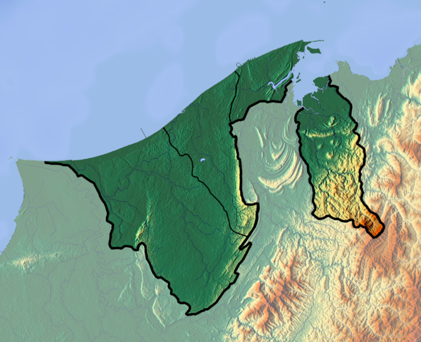
Deutsch: Positionskarte von Brunei
Quadratische Plattkarte. Geographische Begrenzung der Karte:
English: Location map of Brunei
Equirectangular projection. Geographic limits of the map:
|
| நாள் | |
| மூலம் |
சொந்த முயற்சி
|
| ஆசிரியர் | Dr Brains |
அனுமதி
இந்த ஆக்கத்தின் காப்புரிமையாளரான நான் இதனைப் பின்வரும் உரிமத்தின் கீழ் வெளியிடுகின்றேன்:

|
Permission is granted to copy, distribute and/or modify this document under the terms of the GNU Free Documentation License, Version 1.2 only as published by the Free Software Foundation; with no Invariant Sections, no Front-Cover Texts, and no Back-Cover Texts. A copy of the license is included in the section entitled GNU Free Documentation License. | 1.2 மட்டுமே |
|
|
Permission is granted to copy, distribute and/or modify this document under the terms of the GNU Free Documentation License, Version 1.3 or any later version published by the Free Software Foundation; with no Invariant Sections, no Front-Cover Texts, and no Back-Cover Texts. A copy of the license is included in the section entitled GNU Free Documentation License.
|
நீர் உமக்கு விருப்பமான உரிமத்தை தேர்ந்தெடுக்கலாம்.
கோப்பின் வரலாறு
குறித்த நேரத்தில் இருந்த படிமத்தைப் பார்க்க அந்நேரத்தின் மீது சொடுக்கவும்.
| நாள்/நேரம் | நகம் அளவு சிறுபடம் | அளவுகள் | பயனர் | கருத்து | |
|---|---|---|---|---|---|
| தற்போதைய | 11:22, 10 சூன் 2012 | | 2,331 × 1,892 (5.92 MB) | Dr Brains |
கோப்பு பயன்பாடு
பின்வரும் பக்க இணைப்புகள் இப் படிமத்துக்கு இணைக்கபட்டுள்ளது(ளன):
கோப்பின் முழுமையான பயன்பாடு
கீழ்கண்ட மற்ற விக்கிகள் இந்த கோப்பை பயன்படுத்துகின்றன:
- ar.wikipedia.org-திட்டத்தில் இதன் பயன்பாடு
- ast.wikipedia.org-திட்டத்தில் இதன் பயன்பாடு
- bcl.wikipedia.org-திட்டத்தில் இதன் பயன்பாடு
- bn.wikipedia.org-திட்டத்தில் இதன் பயன்பாடு
- bs.wikipedia.org-திட்டத்தில் இதன் பயன்பாடு
- ceb.wikipedia.org-திட்டத்தில் இதன் பயன்பாடு
- ce.wikipedia.org-திட்டத்தில் இதன் பயன்பாடு
- cs.wikipedia.org-திட்டத்தில் இதன் பயன்பாடு
- el.wikipedia.org-திட்டத்தில் இதன் பயன்பாடு
- en.wikipedia.org-திட்டத்தில் இதன் பயன்பாடு
- Brunei
- Geography of Brunei
- Bandar Seri Begawan
- Brunei Bay
- Jerudong Park
- Brunei Open
- Pagon Hill
- Aberdeen Brunei Senior Masters
- Tasek Merimbun
- Ulu Temburong National Park
- Module:Location map/data/Brunei/doc
- Batu Apoi Forest Reserve
- Seria oil field
- Benutan Dam
- Ulu Tutong Dam
- Ash-Shaliheen Mosque
- Pehin Khatib Abdullah Mosque
- Hassanal Bolkiah Mosque
- Hassanal Bolkiah Mosque, Mentiri
- Module:Location map/data/Brunei
- Kedayan River
- Kianggeh River
- Jerudong Park Amphitheater
- Saeh Hill
- Retak Hill
- Tudal Hill
- Lalak Lake
- Serasa Bay
- Teraja Waterfall
- fa.wikipedia.org-திட்டத்தில் இதன் பயன்பாடு
- fr.wikipedia.org-திட்டத்தில் இதன் பயன்பாடு
சிறப்பு பக்கம்-மொத்த பயன்பாடு - இதன் மூலம் இந்த கோப்பின் மொத்த பயன்பாட்டை அறிய முடியும்