
படிமம்:Arab Spring and Regional Conflict Map.svg

Size of this PNG preview of this SVG file: 800 × 406 படப்புள்ளிகள். மற்ற பிரிதிறன்கள்: 320 × 162 படப்புள்ளிகள் | 640 × 325 படப்புள்ளிகள் | 1,024 × 520 படப்புள்ளிகள் | 1,280 × 650 படப்புள்ளிகள் | 2,560 × 1,299 படப்புள்ளிகள் | 940 × 477 படப்புள்ளிகள் .
மூலக்கோப்பு (SVG கோப்பு, பெயரளவில் 940 × 477 பிக்சல்கள், கோப்பு அளவு: 533 KB)
| இது விக்கிமீடியா பொதுக்கோப்பகத்தில் இருக்கும் ஒரு கோப்பாகும். இக்கோப்பைக் குறித்து அங்கே காணப்படும் படிம விளக்கப் பக்கத்தை இங்கே கீழே காணலாம்.
|
சுருக்கம்
| விளக்கம் |
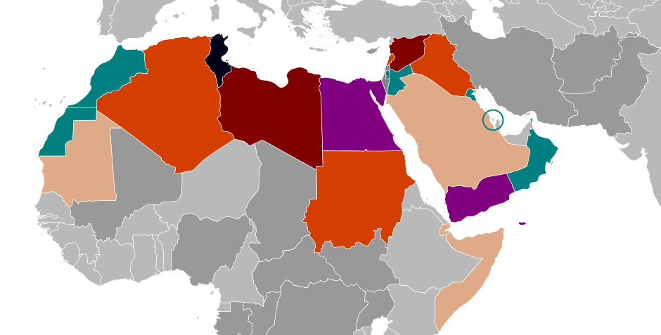
English: A map detailing the various levels of conflict in the West Asian and North African regions. ▇ Government overthrown multiple times ▇ Government overthrown ▇ Civil war ▇ Protests and governmental changes ▇ Major protests ▇ Minor protests |
| நாள் | |
| மூலம் |
This file was derived from: BlankMap-Middle East.svg |
| ஆசிரியர் | Ian Remsen |
| SVG genesis |
அனுமதி
| This work has been released into the public domain by its author, Remsense at ஆங்கிலம் விக்கிப்பீடியா. This applies worldwide. சில நாடுகளில் இது சாத்தியமில்லாது போகலாம். அவ்வாறாயின் : Remsense grants anyone the right to use this work for any purpose, without any conditions, unless such conditions are required by law. |
Original upload log
The original description page was here. All following user names refer to en.wikipedia.
| நாள்/நேரம் | அளவுகள் | பயனர் | கருத்து |
|---|---|---|---|
| 2014-07-24 21:13 | 940×477× (547199 bytes) | Remsense | Uploading a public-domain item using [[Wikipedia:File_Upload_Wizard|File Upload Wizard]] |
கோப்பின் வரலாறு
குறித்த நேரத்தில் இருந்த படிமத்தைப் பார்க்க அந்நேரத்தின் மீது சொடுக்கவும்.
| நாள்/நேரம் | நகம் அளவு சிறுபடம் | அளவுகள் | பயனர் | கருத்து | |
|---|---|---|---|---|---|
| தற்போதைய | 15:33, 8 அக்டோபர் 2022 | | 940 × 477 (533 KB) | Ratherous | Reverted to version as of 15:05, 23 September 2022 (UTC) This has been on the map for year and is included in the many infoboxes on different wikis. Helps to distinguish between outside conflicts and arab spring conflicts. |
| 18:09, 3 அக்டோபர் 2022 |  | 811 × 471 (485 KB) | Weaveravel | Reverted to version as of 11:34, 30 August 2022 (UTC) Sorry but this map is about Arab Spring. Unnecessary to add irrelevant countries to the mix. | |
| 15:05, 23 செப்டெம்பர் 2022 |  | 940 × 477 (533 KB) | Ratherous | Reverted to version as of 23:04, 24 January 2017 (UTC) | |
| 11:34, 30 ஆகத்து 2022 |  | 811 × 471 (485 KB) | Weaveravel | Irrelevant colors removed | |
| 23:04, 24 சனவரி 2017 |  | 940 × 477 (533 KB) | TriadicRelation98 | Changed to a more prominent and unique purple | |
| 00:46, 23 பெப்பிரவரி 2015 |  | 940 × 477 (534 KB) | MiguelMadeira | Change in Libya and Yemen | |
| 09:22, 11 திசம்பர் 2014 |  | 940 × 477 (534 KB) | AntanO | Transferred from en.wikipedia |
கோப்பு பயன்பாடு
பின்வரும் பக்க இணைப்புகள் இப் படிமத்துக்கு இணைக்கபட்டுள்ளது(ளன):
கோப்பின் முழுமையான பயன்பாடு
கீழ்கண்ட மற்ற விக்கிகள் இந்த கோப்பை பயன்படுத்துகின்றன:
- ar.wikipedia.org-திட்டத்தில் இதன் பயன்பாடு
- ary.wikipedia.org-திட்டத்தில் இதன் பயன்பாடு
- arz.wikipedia.org-திட்டத்தில் இதன் பயன்பாடு
- ba.wikipedia.org-திட்டத்தில் இதன் பயன்பாடு
- bg.wikipedia.org-திட்டத்தில் இதன் பயன்பாடு
- ca.wikipedia.org-திட்டத்தில் இதன் பயன்பாடு
- ckb.wikipedia.org-திட்டத்தில் இதன் பயன்பாடு
- cs.wikipedia.org-திட்டத்தில் இதன் பயன்பாடு
- cy.wikipedia.org-திட்டத்தில் இதன் பயன்பாடு
- el.wikipedia.org-திட்டத்தில் இதன் பயன்பாடு
- en.wikipedia.org-திட்டத்தில் இதன் பயன்பாடு
- en.wikinews.org-திட்டத்தில் இதன் பயன்பாடு
- es.wikipedia.org-திட்டத்தில் இதன் பயன்பாடு
- fa.wikipedia.org-திட்டத்தில் இதன் பயன்பாடு
- ga.wikipedia.org-திட்டத்தில் இதன் பயன்பாடு
- gl.wikipedia.org-திட்டத்தில் இதன் பயன்பாடு
- it.wikipedia.org-திட்டத்தில் இதன் பயன்பாடு
- kab.wikipedia.org-திட்டத்தில் இதன் பயன்பாடு
- ka.wikipedia.org-திட்டத்தில் இதன் பயன்பாடு
- ki.wikipedia.org-திட்டத்தில் இதன் பயன்பாடு
- ko.wikipedia.org-திட்டத்தில் இதன் பயன்பாடு
- ml.wikipedia.org-திட்டத்தில் இதன் பயன்பாடு
- ne.wikipedia.org-திட்டத்தில் இதன் பயன்பாடு
- nl.wikipedia.org-திட்டத்தில் இதன் பயன்பாடு
- pl.wikipedia.org-திட்டத்தில் இதன் பயன்பாடு
- pnb.wikipedia.org-திட்டத்தில் இதன் பயன்பாடு
- pt.wikipedia.org-திட்டத்தில் இதன் பயன்பாடு
- ru.wikinews.org-திட்டத்தில் இதன் பயன்பாடு
- sk.wikipedia.org-திட்டத்தில் இதன் பயன்பாடு
- th.wikipedia.org-திட்டத்தில் இதன் பயன்பாடு
- tr.wikiquote.org-திட்டத்தில் இதன் பயன்பாடு
- uk.wikipedia.org-திட்டத்தில் இதன் பயன்பாடு
- ur.wikipedia.org-திட்டத்தில் இதன் பயன்பாடு
- www.wikidata.org-திட்டத்தில் இதன் பயன்பாடு
- zh.wikipedia.org-திட்டத்தில் இதன் பயன்பாடு