
படிமம்:Map Anatolia ancient regions-en.svg

மூலக்கோப்பு (SVG கோப்பு, பெயரளவில் 921 × 596 பிக்சல்கள், கோப்பு அளவு: 256 KB)
| இது விக்கிமீடியா பொதுக்கோப்பகத்தில் இருக்கும் ஒரு கோப்பாகும். இக்கோப்பைக் குறித்து அங்கே காணப்படும் படிம விளக்கப் பக்கத்தை இங்கே கீழே காணலாம்.
|
| விளக்கம் |
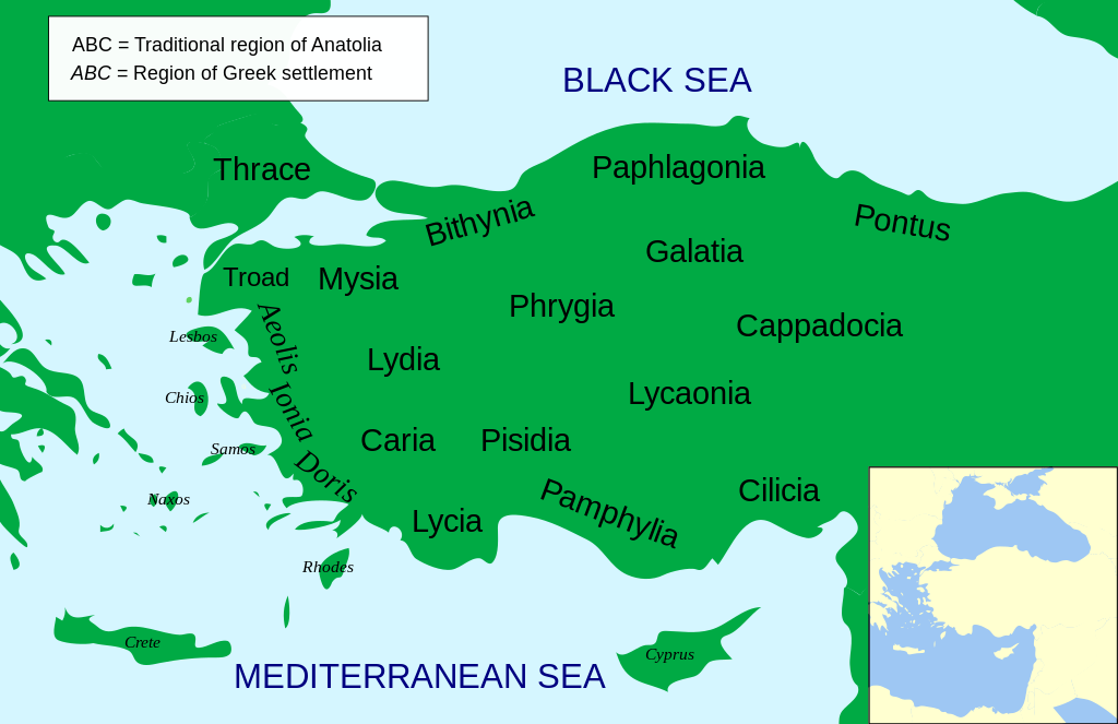
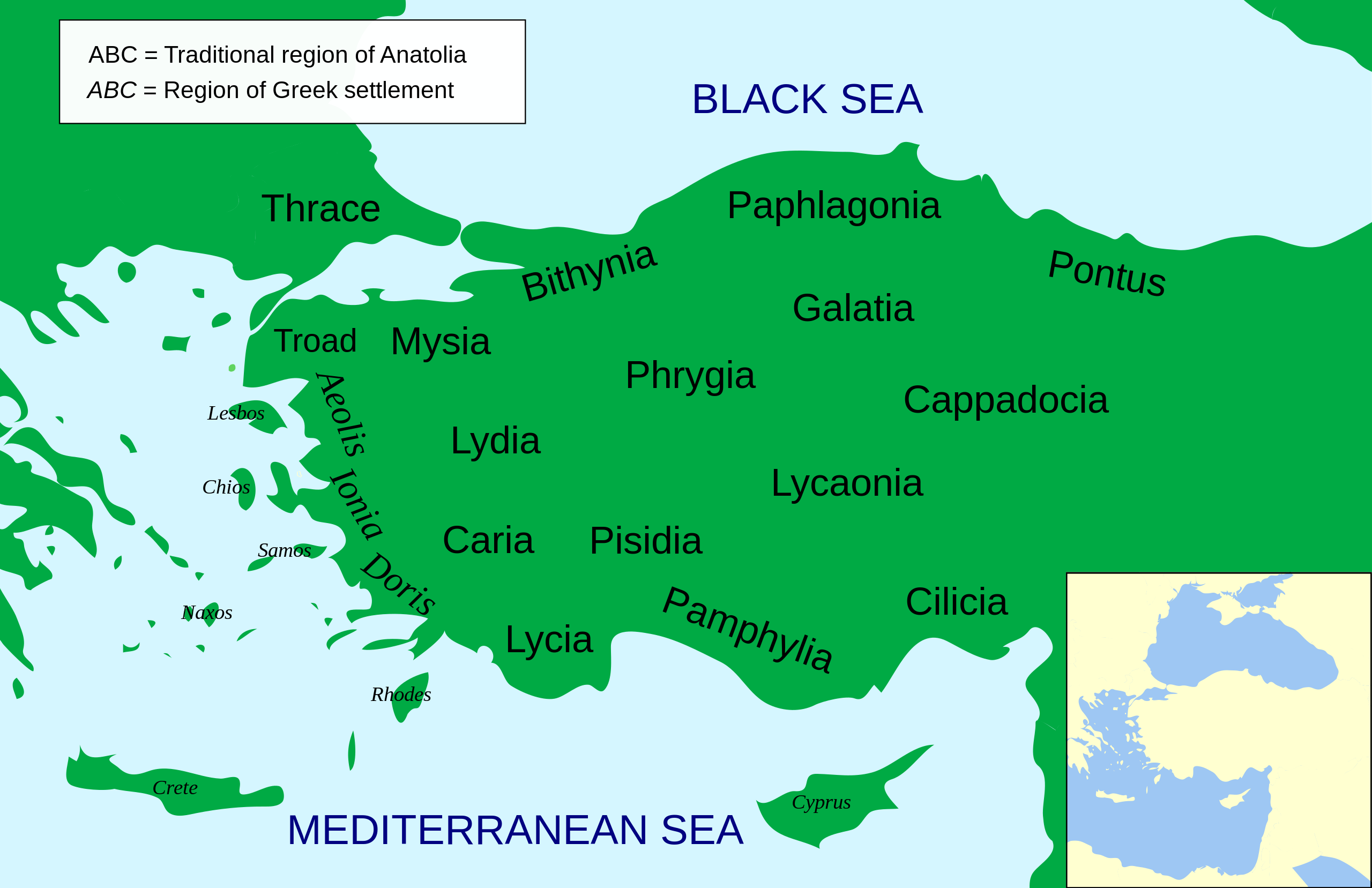
Català: Mapa regional d'Àsia Menor al segle II aC
English: Regional map of Asia Minor in the 2nd Century BC |
| நாள் | (UTC) |
| மூலம் | |
| ஆசிரியர் |
|
| ஒத்தக்கோப்பு |
Other related versions: []
Derivative works of this file: |


.svg)


|
This SVG file contains embedded text that can be translated into your language, using any capable SVG editor, text editor or the SVG Translate tool. For more information see: About translating SVG files. |
This file is translated using SVG <switch> elements. All translations are stored in the same file! Learn more.
For most Wikipedia projects, you can embed the file normally (without a To translate the text into your language, you can use the SVG Translate tool. Alternatively, you can download the file to your computer, add your translations using whatever software you're familiar with, and re-upload it with the same name. You will find help in Graphics Lab if you're not sure how to do this. |
| இது ஒரு திருத்தப்பட்ட படிமமாகும், அதாவது இதன் மூல வடிவத்திலிருந்து கணினி மூலம் இதில் மாற்றங்கள் செய்யப்பட்டுள்ளது. திருத்தங்கள்: Increased legibility, slight corrections in position. மூலக்கோப்பை இங்கு காணலாம்: Asia Minor Political 500BC.svg. திருத்தங்களைச் செய்தவர் MinisterForBadTimes.
|
- நீங்கள் சுதந்திரமாக:
- பகிர்ந்து கொள்ள – வேலையை நகலெடுக்க, விநியோகிக்க மற்றும் அனுப்ப
- மீண்டும் கலக்க – வேலைக்கு பழகிக்கொள்ள.
- கீழ்க்காணும் விதிகளுக்கு ஏற்ப,
- பண்புக்கூறுகள் – நீங்கள் பொருத்தமான உரிமையை வழங்க வேண்டும், உரிமத்திற்கான இணைப்பை வழங்க வேண்டும் மற்றும் மாற்றங்கள் செய்யப்பட்டிருந்தால் குறிப்பிட வேண்டும். நீங்கள் ஏற்புடைய எந்த முறையிலும் அவ்வாறு செய்யலாம், ஆனால் எந்த வகையிலும் உரிமதாரர் உங்களை அல்லது உங்கள் பயன்பாட்டிற்கு ஒப்புதல் அளிக்கும் படி பரிந்துரைக்க கூடாது.
- அதே மாதிரி பகிர் – நீங்கள் ரீமிக்ஸ் செய்தாலோ, உருமாற்றம் செய்தாலோ அல்லது பொருளை உருவாக்கினாலோ, உங்கள் பங்களிப்புகளை அல்லது இணக்கமான உரிமம் கீழ் அசலாக விநியோகிக்க வேண்டும்.

|
GNU Free Documentation License விதிமுறைகளின் கீழ் இந்த ஆவணத்தை நகலெடுக்க, விநியோகிக்க மற்றும்/அல்லது மாற்றுவதற்கு அனுமதி வழங்கப்பட்டுள்ளது, Free Software Foundation;ஆல் வெளியிடப்பட்ட பதிப்பு 1.2 அல்லது அதற்குப் பிந்தைய பதிப்பு, மாற்றமில்லாத பிரிவுகள், முன் அட்டை உரைகள் மற்றும் பின் அட்டை உரைகள் இல்லாமல் வெளியிடப்பட்டது. GNU Free Documentation License என்ற தலைப்பில் உரிமத்தின் நகல் சேர்க்கப்பட்டுள்ளது. |
Original upload log
This image is a derivative work of the following images:
- File:Asia_Minor_Political_500BC.svg licensed with Cc-by-sa-3.0, GFDL
- 2009-04-22T07:38:42Z MinisterForBadTimes 921x596 (283615 Bytes) Coloured in rogue region
- 2009-04-22T07:36:20Z MinisterForBadTimes 921x596 (283353 Bytes) Changed fonts...again
- 2009-04-22T07:33:39Z MinisterForBadTimes 921x596 (283414 Bytes) Changed fonts
- 2009-04-22T07:25:50Z MinisterForBadTimes 921x596 (284262 Bytes) {{Information |Description={{en|1= Political map of Asia Minor in 500 BC}} |Source=*[[:File:Mysia.svg|]] |Date=2009-04-22 08:23 (UTC) |Author=*[[:File:Mysia.svg|]]: [[User:Emok|Emok]] *derivative work: *[[:Image:Mysia_map_anc
Uploaded with derivativeFX
கோப்பின் வரலாறு
குறித்த நேரத்தில் இருந்த படிமத்தைப் பார்க்க அந்நேரத்தின் மீது சொடுக்கவும்.
| நாள்/நேரம் | நகம் அளவு சிறுபடம் | அளவுகள் | பயனர் | கருத்து | |
|---|---|---|---|---|---|
| தற்போதைய | 14:14, 15 பெப்பிரவரி 2024 | | 921 × 596 (256 KB) | Manlleus | File uploaded using svgtranslate tool (https://svgtranslate.toolforge.org/). Added translation for ca. |
| 14:01, 15 பெப்பிரவரி 2024 |  | 921 × 596 (235 KB) | Manlleus | fixed text labels for translation | |
| 19:48, 23 ஏப்பிரல் 2009 |  | 921 × 596 (278 KB) | MinisterForBadTimes | Added Galatia, minor other changes | |
| 16:01, 22 ஏப்பிரல் 2009 |  | 921 × 596 (277 KB) | MinisterForBadTimes | {{Information |Description={{en|1= Political map of Asia Minor in 500 BC}} |Source=*File:Asia_Minor_Political_500BC.svg |Date=2009-04-22 17:00 (UTC) |Author=*File:Asia_Minor_Political_500BC.svg: *Mysia.svg: [[User:Emok|Emok |
கோப்பு பயன்பாடு
பின்வரும் பக்க இணைப்புகள் இப் படிமத்துக்கு இணைக்கபட்டுள்ளது(ளன):
கோப்பின் முழுமையான பயன்பாடு
கீழ்கண்ட மற்ற விக்கிகள் இந்த கோப்பை பயன்படுத்துகின்றன:
- af.wikipedia.org-திட்டத்தில் இதன் பயன்பாடு
- als.wikipedia.org-திட்டத்தில் இதன் பயன்பாடு
- am.wikipedia.org-திட்டத்தில் இதன் பயன்பாடு
- ar.wikipedia.org-திட்டத்தில் இதன் பயன்பாடு
- azb.wikipedia.org-திட்டத்தில் இதன் பயன்பாடு
- az.wikipedia.org-திட்டத்தில் இதன் பயன்பாடு
- be-tarask.wikipedia.org-திட்டத்தில் இதன் பயன்பாடு
- bg.wikipedia.org-திட்டத்தில் இதன் பயன்பாடு
- bn.wikipedia.org-திட்டத்தில் இதன் பயன்பாடு
- br.wikipedia.org-திட்டத்தில் இதன் பயன்பாடு
- bs.wikipedia.org-திட்டத்தில் இதன் பயன்பாடு
- ca.wikipedia.org-திட்டத்தில் இதன் பயன்பாடு
- cs.wikipedia.org-திட்டத்தில் இதன் பயன்பாடு
- da.wikipedia.org-திட்டத்தில் இதன் பயன்பாடு
- de.wikipedia.org-திட்டத்தில் இதன் பயன்பாடு
- diq.wikipedia.org-திட்டத்தில் இதன் பயன்பாடு
- en.wikipedia.org-திட்டத்தில் இதன் பயன்பாடு
சிறப்பு பக்கம்-மொத்த பயன்பாடு - இதன் மூலம் இந்த கோப்பின் மொத்த பயன்பாட்டை அறிய முடியும்