
படிமம்:AMH-4554-NA Map of Vyf Sinnen castle at Nagapatnam.jpg
இந்த முன்னோட்டத்தின் அளவு: 800 × 569 படப்புள்ளிகள் . மற்ற பிரிதிறன்கள்: 320 × 227 படப்புள்ளிகள் | 640 × 455 படப்புள்ளிகள் | 1,024 × 728 படப்புள்ளிகள் | 1,280 × 910 படப்புள்ளிகள் | 2,400 × 1,706 படப்புள்ளிகள் .
மூலக்கோப்பு (2,400 × 1,706 படவணுக்கள், கோப்பின் அளவு: 680 KB, MIME வகை: image/jpeg)
| இது விக்கிமீடியா பொதுக்கோப்பகத்தில் இருக்கும் ஒரு கோப்பாகும். இக்கோப்பைக் குறித்து அங்கே காணப்படும் படிம விளக்கப் பக்கத்தை இங்கே கீழே காணலாம்.
|
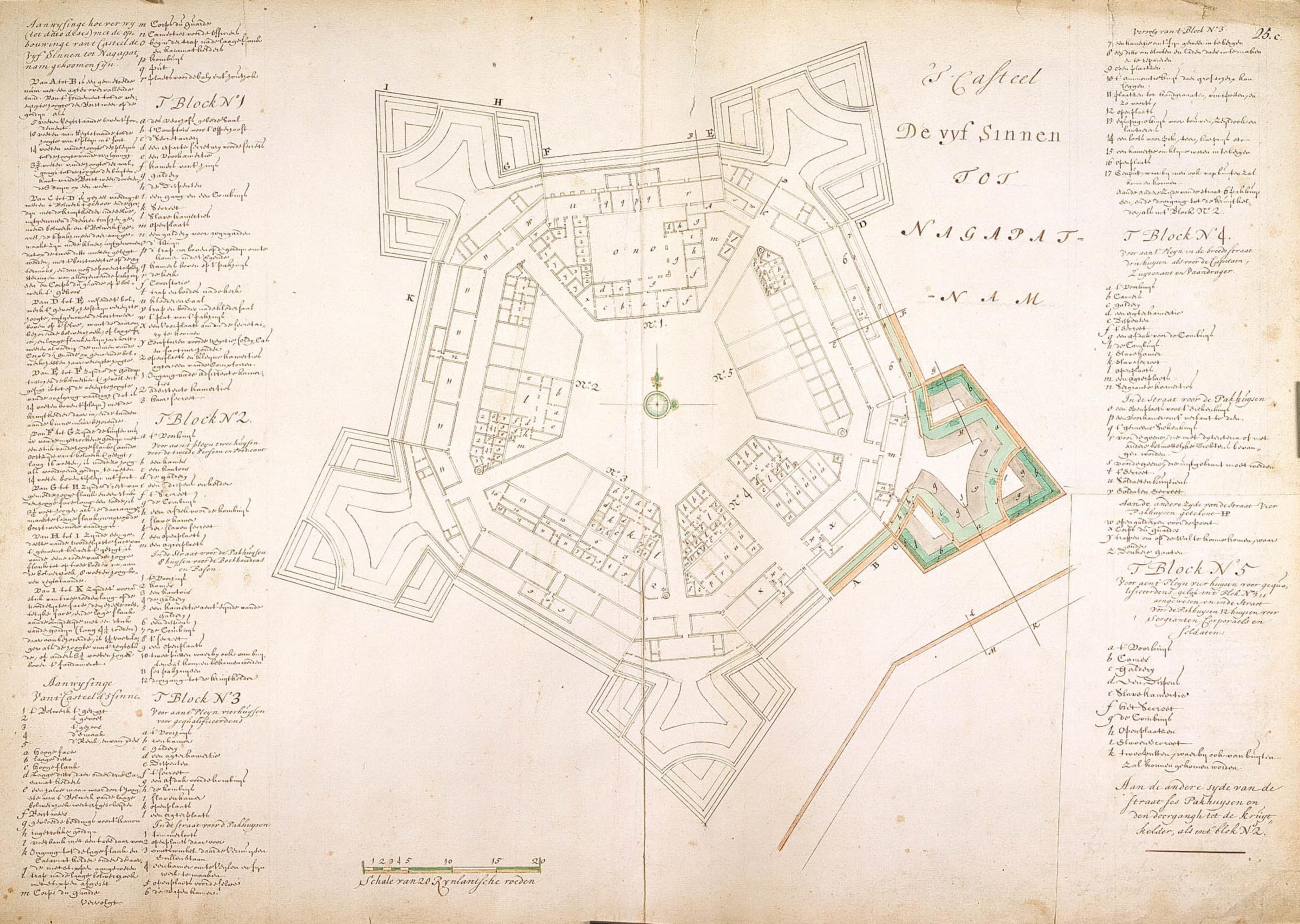
சுருக்கம்
Nederlands: Plattegrond van kasteel de Vyf Sinnen te Nagapatnam
English: Map of Vyf Sinnen castle at Nagapatnam( |
||||||||||||||||||||||||||
|---|---|---|---|---|---|---|---|---|---|---|---|---|---|---|---|---|---|---|---|---|---|---|---|---|---|---|
| ஆசிரியர் |
Nederlands: Isaac de Graaff (landmeter / kaartenmaker)
English: Isaac de Graaff (land surveyor / mapmaker) |
|||||||||||||||||||||||||
| தலைப்பு |
Nederlands: Plattegrond van kasteel de Vyf Sinnen te Nagapatnam
English: Map of Vyf Sinnen castle at Nagapatnam |
|||||||||||||||||||||||||
| விளக்கம் |
Nederlands: Titel catalogus Leupe (NA): Plan van 't Casteel de Vyf Sinnen, tot Nagapatnam.
Diverse legenda's.
English: According to the Leupe catalogue (NA), the original title reads: Plan van 't Casteel de Vyf Sinnen, tot Nagapatnam.
Various keys. |
|||||||||||||||||||||||||
| நாள் | 1700 - 1800 | |||||||||||||||||||||||||
| நடுத்தரம் |
Nederlands: ingekleurde tekening op papier
English: coloured drawing on paper |
|||||||||||||||||||||||||
| பரிமானங்கள் | உயரம்: ௭௫.௦ ச.மீ.; அகலம்: ௫௩.௦ ச.மீ. | |||||||||||||||||||||||||
| திரட்டு |
|
|||||||||||||||||||||||||
| ஏற்பு இலக்கம் |
NL-HaNA_4.VEL_1083 (old number: VEL1083) |
|||||||||||||||||||||||||
| பதிவு செய்தல் |
'T Casteel De Vyf Sinnen tot Nagapatnam
|
|||||||||||||||||||||||||
| குறிப்புகள் |
English: Subjects: key, fortification, chart / map / plan
Nederlands: Onderwerpen: legenda, vesting, plattegrond / kaart
English: Fort: this image is related to a VOC fort called fort Vijf Sinnen |
|||||||||||||||||||||||||
| மூலம்/படப்பிடிப்பாளர் |
|
|||||||||||||||||||||||||
| அனுமதி (இக்கோப்பை மீண்டும் பயன்படுத்துதல்) |
|
|||||||||||||||||||||||||

| Object location | | View this and other nearby images on: OpenStreetMap |
|---|
கோப்பின் வரலாறு
குறித்த நேரத்தில் இருந்த படிமத்தைப் பார்க்க அந்நேரத்தின் மீது சொடுக்கவும்.
| நாள்/நேரம் | நகம் அளவு சிறுபடம் | அளவுகள் | பயனர் | கருத்து | |
|---|---|---|---|---|---|
| தற்போதைய | 16:36, 10 சூன் 2014 | | 2,400 × 1,706 (680 KB) | HuskyBot | == {{int:filedesc}} == {{Artwork |title = {{nl|1=Plattegrond van kasteel de Vyf Sinnen te Nagapatnam}} {{en|1=Map of Vyf Sinnen castle at Nagapatnam}} |description = {{nl|1=Titel catalogus Leupe (NA): ''Plan va... |
கோப்பு பயன்பாடு
பின்வரும் பக்க இணைப்புகள் இப் படிமத்துக்கு இணைக்கபட்டுள்ளது(ளன):
கோப்பின் முழுமையான பயன்பாடு
கீழ்கண்ட மற்ற விக்கிகள் இந்த கோப்பை பயன்படுத்துகின்றன:
- en.wikipedia.org-திட்டத்தில் இதன் பயன்பாடு
- nl.wikipedia.org-திட்டத்தில் இதன் பயன்பாடு
- www.wikidata.org-திட்டத்தில் இதன் பயன்பாடு