
படிமம்:1995 Atlantic hurricane season summary map.png

இந்த முன்னோட்டத்தின் அளவு: 800 × 495 படப்புள்ளிகள் . மற்ற பிரிதிறன்கள்: 320 × 198 படப்புள்ளிகள் | 640 × 396 படப்புள்ளிகள் | 1,024 × 634 படப்புள்ளிகள் | 1,280 × 792 படப்புள்ளிகள் | 2,560 × 1,585 படப்புள்ளிகள் | 4,000 × 2,476 படப்புள்ளிகள் .
மூலக்கோப்பு (4,000 × 2,476 படவணுக்கள், கோப்பின் அளவு: 6.37 MB, MIME வகை: image/png)
| இது விக்கிமீடியா பொதுக்கோப்பகத்தில் இருக்கும் ஒரு கோப்பாகும். இக்கோப்பைக் குறித்து அங்கே காணப்படும் படிம விளக்கப் பக்கத்தை இங்கே கீழே காணலாம்.
|
| விளக்கம் |
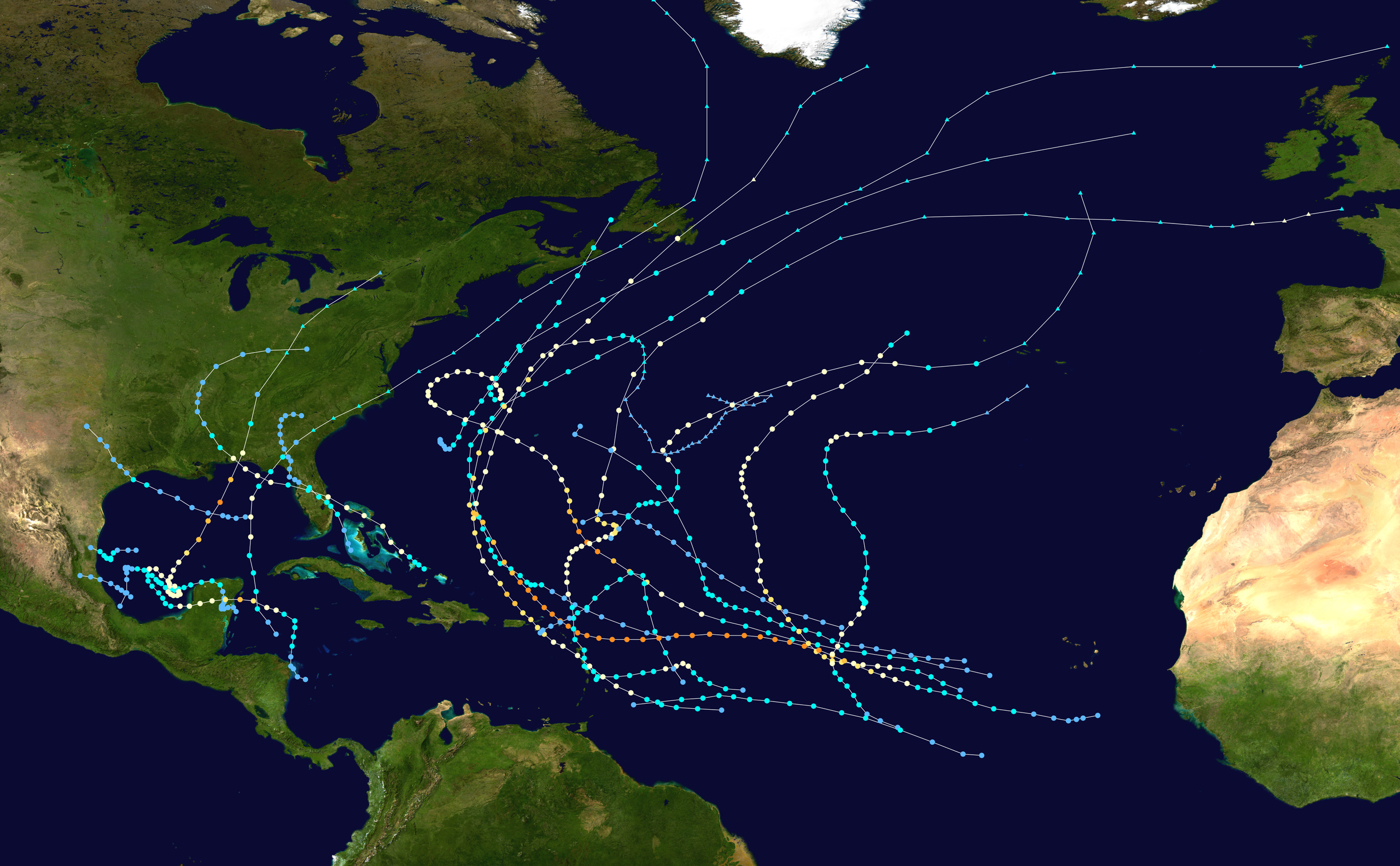
English: This map shows the tracks of all tropical cyclones in the 1995 Atlantic hurricane season. The points show the location of each storm at 6-hour intervals. The colour represents the storm's maximum sustained wind speeds as classified in the Saffir-Simpson Hurricane Scale (see below), and the shape of the data points represent the type of the storm.
Tropical depression (≤38 mph, ≤62 km/h)
Tropical storm (39–73 mph, 63–118 km/h)
Category 1 (74–95 mph, 119–153 km/h)
Category 2 (96–110 mph, 154–177 km/h)
Category 3 (111–129 mph, 178–208 km/h)
Category 4 (130–156 mph, 209–251 km/h)
Category 5 (≥157 mph, ≥252 km/h)
Unknown
Storm type |
| மூலம் | Created using Wikipedia:WikiProject Tropical cyclones/Tracks. The background image is from தேசிய வானூர்தியியல் மற்றும் விண்வெளி நிர்வாகம் [1]. The tracking data is from the National Hurricane Center's Atlantic hurricane database |
| ஆசிரியர் | Supportstorm |

|
This file may be updated to reflect new information. If you wish to use a specific version of the file without new updates being mirrored, please upload the required version as a separate file. |
| This work has been released into the public domain by its author, Supportstorm. This applies worldwide. சில நாடுகளில் இது சாத்தியமில்லாது போகலாம். அவ்வாறாயின் : Supportstorm grants anyone the right to use this work for any purpose, without any conditions, unless such conditions are required by law. |
கோப்பின் வரலாறு
குறித்த நேரத்தில் இருந்த படிமத்தைப் பார்க்க அந்நேரத்தின் மீது சொடுக்கவும்.
| நாள்/நேரம் | நகம் அளவு சிறுபடம் | அளவுகள் | பயனர் | கருத்து | |
|---|---|---|---|---|---|
| தற்போதைய | 03:33, 28 சனவரி 2020 | | 4,000 × 2,476 (6.37 MB) | Supportstorm | Standard dimensions |
| 18:52, 9 சூன் 2013 |  | 3,000 × 1,854 (4.27 MB) | Supportstorm | {{Hurricane season auto track map|start=|end=|source=ATL|type=hurricane|basin=Atlantic|year=1995|author=Supportstorm}} |
கோப்பு பயன்பாடு
பின்வரும் பக்க இணைப்புகள் இப் படிமத்துக்கு இணைக்கபட்டுள்ளது(ளன):
கோப்பின் முழுமையான பயன்பாடு
கீழ்கண்ட மற்ற விக்கிகள் இந்த கோப்பை பயன்படுத்துகின்றன:
- de.wikipedia.org-திட்டத்தில் இதன் பயன்பாடு
- en.wikipedia.org-திட்டத்தில் இதன் பயன்பாடு
- Hurricane Opal
- 1995 Atlantic hurricane season
- Hurricane Roxanne
- Hurricane Luis
- Hurricane Marilyn
- Hurricane Erin (1995)
- Hurricane Allison (1995)
- Template:1995 Atlantic hurricane season buttons
- Hurricane Felix (1995)
- Tropical Storm Jerry (1995)
- Hurricane Iris (1995)
- Tropical Storm Gabrielle (1995)
- Tropical Storm Dean (1995)
- Hurricane Tanya
- Timeline of the 1995 Atlantic hurricane season
- Meteorological history of Hurricane Luis
- User:TheAustinMan/sandbox/Hurricane Opal
- User:Khaled98/1995 hurricane reanalysis
- es.wikipedia.org-திட்டத்தில் இதன் பயன்பாடு
- fr.wikipedia.org-திட்டத்தில் இதன் பயன்பாடு
- he.wikipedia.org-திட்டத்தில் இதன் பயன்பாடு