
படிமம்:Six Day War Territories 2.png
இதைவிட அளவில் பெரிய படிமம் இல்லை.
Six_Day_War_Territories_2.png (398 × 599 படவணுக்கள், கோப்பின் அளவு: 52 KB, MIME வகை: image/png)
| இது விக்கிமீடியா பொதுக்கோப்பகத்தில் இருக்கும் ஒரு கோப்பாகும். இக்கோப்பைக் குறித்து அங்கே காணப்படும் படிம விளக்கப் பக்கத்தை இங்கே கீழே காணலாம்.
|
சுருக்கம்

|
File:Six Day War Terrritories.svg என்பது இந்தக் கோப்பின் திசையன் வடிவமாகும். இந்தக் PNG கோப்பின் இடத்தில் திசையன் கோப்புத் தரம் குறைவாக இல்லாவனில் இதைப் பயன்படுத்த வேண்டும்.
File:Six Day War Territories 2.png → File:Six Day War Terrritories.svg
மேலும் தகவலுக்கு, உதவி:SVG பார்க்கவும். |
 |
| விளக்கம் |
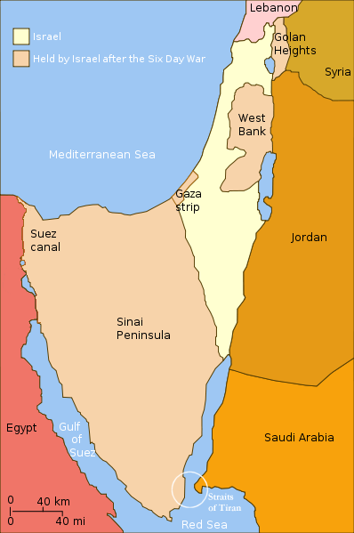
English: Israel and the territories Israel occupied in the Six day war. |
| நாள் | (UTC) |
| மூலம் | |
| ஆசிரியர் |
|
| ஒத்தக்கோப்பு |
[]
|


.png)


| இது ஒரு திருத்தப்பட்ட படிமமாகும், அதாவது இதன் மூல வடிவத்திலிருந்து கணினி மூலம் இதில் மாற்றங்கள் செய்யப்பட்டுள்ளது. திருத்தங்கள்: Changed "Israeli territory before the Six day war" to "Israel", since Israels territory before the Six day war is the same as after. மூலக்கோப்பை இங்கு காணலாம்: Six Day War Terrritories.png. திருத்தங்களைச் செய்தவர் Supreme Deliciousness.
|
இந்த ஆக்கத்தின் காப்புரிமையாளரான நான் இதனைப் பின்வரும் உரிமத்தின் கீழ் வெளியிடுகின்றேன்:
This file is licensed under the Creative Commons Attribution-Share Alike 2.5 Generic license.
- நீங்கள் சுதந்திரமாக:
- பகிர்ந்து கொள்ள – வேலையை நகலெடுக்க, விநியோகிக்க மற்றும் அனுப்ப
- மீண்டும் கலக்க – வேலைக்கு பழகிக்கொள்ள.
- கீழ்க்காணும் விதிகளுக்கு ஏற்ப,
- பண்புக்கூறுகள் – நீங்கள் பொருத்தமான உரிமையை வழங்க வேண்டும், உரிமத்திற்கான இணைப்பை வழங்க வேண்டும் மற்றும் மாற்றங்கள் செய்யப்பட்டிருந்தால் குறிப்பிட வேண்டும். நீங்கள் ஏற்புடைய எந்த முறையிலும் அவ்வாறு செய்யலாம், ஆனால் எந்த வகையிலும் உரிமதாரர் உங்களை அல்லது உங்கள் பயன்பாட்டிற்கு ஒப்புதல் அளிக்கும் படி பரிந்துரைக்க கூடாது.
- அதே மாதிரி பகிர் – நீங்கள் ரீமிக்ஸ் செய்தாலோ, உருமாற்றம் செய்தாலோ அல்லது பொருளை உருவாக்கினாலோ, உங்கள் பங்களிப்புகளை அல்லது இணக்கமான உரிமம் கீழ் அசலாக விநியோகிக்க வேண்டும்.
Original upload log
This image is a derivative work of the following images:
- File:Six_Day_War_Terrritories.png licensed with Cc-by-sa-2.5
- 2010-11-11T21:32:04Z 99of9 398x599 (53810 Bytes) Reverted to version as of 07:04, 25 July 2010. Both POV versions should be at different locations, marked with POV and linked.
- 2010-11-08T11:06:48Z Supreme Deliciousness 398x599 (53223 Bytes) Israeli territory before the Six day war is the same as after the Six day war.
- 2010-07-25T07:04:14Z Ling.Nut 398x599 (53810 Bytes) {{Information |Description={{en|1=Israeli territories before and after the Six Day War. The Straits of Tiran are circled, between the Gulf of Aqaba, and the Red Sea.}} |Source=Yom Kippur War map.svg |Author=[[User:Ling.Nut]]
Uploaded with derivativeFX
கோப்பின் வரலாறு
குறித்த நேரத்தில் இருந்த படிமத்தைப் பார்க்க அந்நேரத்தின் மீது சொடுக்கவும்.
| நாள்/நேரம் | நகம் அளவு சிறுபடம் | அளவுகள் | பயனர் | கருத்து | |
|---|---|---|---|---|---|
| தற்போதைய | 12:15, 12 நவம்பர் 2010 | | 398 × 599 (52 KB) | Supreme Deliciousness | {{Information |Description={{en|1=Israel and the territories Israel occupied in the Six day war.</br>in yellow: Israel within the "Green Line" borders (per 1949 ceasefire agreements); in light maroon: Territories Israel seized during |
கோப்பு பயன்பாடு
பின்வரும் பக்க இணைப்புகள் இப் படிமத்துக்கு இணைக்கபட்டுள்ளது(ளன):
கோப்பின் முழுமையான பயன்பாடு
கீழ்கண்ட மற்ற விக்கிகள் இந்த கோப்பை பயன்படுத்துகின்றன:
- als.wikipedia.org-திட்டத்தில் இதன் பயன்பாடு
- da.wikipedia.org-திட்டத்தில் இதன் பயன்பாடு
- en.wikipedia.org-திட்டத்தில் இதன் பயன்பாடு
- fr.wikipedia.org-திட்டத்தில் இதன் பயன்பாடு
- gl.wikipedia.org-திட்டத்தில் இதன் பயன்பாடு
- ja.wikipedia.org-திட்டத்தில் இதன் பயன்பாடு
- my.wikipedia.org-திட்டத்தில் இதன் பயன்பாடு
- no.wikipedia.org-திட்டத்தில் இதன் பயன்பாடு
- pl.wikipedia.org-திட்டத்தில் இதன் பயன்பாடு
- sh.wikipedia.org-திட்டத்தில் இதன் பயன்பாடு
- sv.wikipedia.org-திட்டத்தில் இதன் பயன்பாடு
- sv.wikiversity.org-திட்டத்தில் இதன் பயன்பாடு