
படிமம்:DST Countries Map.png

இந்த முன்னோட்டத்தின் அளவு: 800 × 355 படப்புள்ளிகள் . மற்ற பிரிதிறன்கள்: 320 × 142 படப்புள்ளிகள் | 640 × 284 படப்புள்ளிகள் | 1,024 × 454 படப்புள்ளிகள் | 1,280 × 568 படப்புள்ளிகள் | 2,560 × 1,136 படப்புள்ளிகள் | 4,952 × 2,197 படப்புள்ளிகள் .
மூலக்கோப்பு (4,952 × 2,197 படவணுக்கள், கோப்பின் அளவு: 462 KB, MIME வகை: image/png)
| இது விக்கிமீடியா பொதுக்கோப்பகத்தில் இருக்கும் ஒரு கோப்பாகும். இக்கோப்பைக் குறித்து அங்கே காணப்படும் படிம விளக்கப் பக்கத்தை இங்கே கீழே காணலாம்.
|
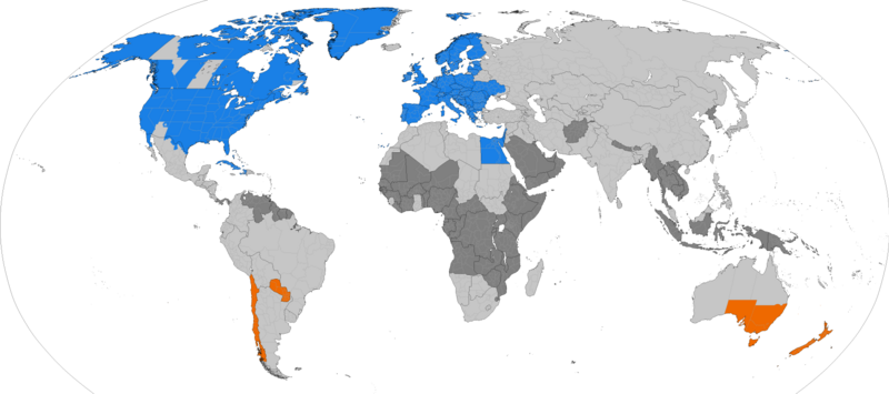
Dark grey places have never used daylight savings, light grey places formerly used it. Orange places use daylight savings in the southern hemisphere summer. Blue places use daylight savings in the northern hemisphere summer.

|
This file may be updated to reflect new information. If you wish to use a specific version of the file without new updates being mirrored, please upload the required version as a separate file. |

|
This map of the world image could be re-created using vector graphics as an SVG file. This has several advantages; see Commons:Media for cleanup for more information. If an SVG form of this image is available, please upload it and afterwards replace this template with
{{vector version available|new image name}}.
It is recommended to name the SVG file “DST Countries Map.svg”—then the template Vector version available (or Vva) does not need the new image name parameter. |
சுருக்கம்
| விளக்கம் |
English: Larger map of the previous version. Distinguished from summertime in the northern hemisphere and southern hemisphere.
Northern hemisphere summer
Southern hemisphere summer
Formerly used daylight savings
Never used daylight savings |
| நாள் | |
| மூலம் | சொந்த முயற்சி |
| ஆசிரியர் | TimeZonesBoy |
| ஒத்தக்கோப்பு |
Supplementary map: |

அனுமதி
இந்த ஆக்கத்தின் காப்புரிமையாளரான நான் இதனைப் பின்வரும் உரிமத்தின் கீழ் வெளியிடுகின்றேன்:
இந்த கோப்பு Creative Commons Attribution-Share Alike 3.0 Unported உரிமத்தின் கீழ் உள்ளது.
- நீங்கள் சுதந்திரமாக:
- பகிர்ந்து கொள்ள – வேலையை நகலெடுக்க, விநியோகிக்க மற்றும் அனுப்ப
- மீண்டும் கலக்க – வேலைக்கு பழகிக்கொள்ள.
- கீழ்க்காணும் விதிகளுக்கு ஏற்ப,
- பண்புக்கூறுகள் – நீங்கள் பொருத்தமான உரிமையை வழங்க வேண்டும், உரிமத்திற்கான இணைப்பை வழங்க வேண்டும் மற்றும் மாற்றங்கள் செய்யப்பட்டிருந்தால் குறிப்பிட வேண்டும். நீங்கள் ஏற்புடைய எந்த முறையிலும் அவ்வாறு செய்யலாம், ஆனால் எந்த வகையிலும் உரிமதாரர் உங்களை அல்லது உங்கள் பயன்பாட்டிற்கு ஒப்புதல் அளிக்கும் படி பரிந்துரைக்க கூடாது.
- அதே மாதிரி பகிர் – நீங்கள் ரீமிக்ஸ் செய்தாலோ, உருமாற்றம் செய்தாலோ அல்லது பொருளை உருவாக்கினாலோ, உங்கள் பங்களிப்புகளை அல்லது இணக்கமான உரிமம் கீழ் அசலாக விநியோகிக்க வேண்டும்.
கோப்பின் வரலாறு
குறித்த நேரத்தில் இருந்த படிமத்தைப் பார்க்க அந்நேரத்தின் மீது சொடுக்கவும்.
| நாள்/நேரம் | நகம் அளவு சிறுபடம் | அளவுகள் | பயனர் | கருத்து | |
|---|---|---|---|---|---|
| தற்போதைய | 06:06, 31 மார்ச்சு 2024 | | 4,952 × 2,197 (462 KB) | Heitordp | Adjusted Greenland |
| 11:27, 31 திசம்பர் 2023 |  | 4,952 × 2,197 (462 KB) | Heitordp | Updated Greenland, disputed borders, subdivisions of France, Morocco, DR Congo, South Sudan, Ethiopia, Somalia, India | |
| 09:44, 23 ஏப்பிரல் 2023 |  | 4,952 × 2,197 (463 KB) | Heitordp | Updated Ukraine | |
| 21:51, 5 ஏப்பிரல் 2023 |  | 4,952 × 2,197 (463 KB) | Heitordp | Updated most of Greenland, law specifies UTC–2 with no DST in 2023 | |
| 13:30, 27 மார்ச்சு 2023 |  | 4,952 × 2,197 (462 KB) | Heitordp | Corrected northeast Greenland and Qikiqtaaluk island | |
| 20:58, 1 மார்ச்சு 2023 |  | 4,952 × 2,197 (462 KB) | Heitordp | Updated Egypt, adjusted Kazakhstan | |
| 06:48, 30 நவம்பர் 2022 |  | 4,952 × 2,197 (462 KB) | Heitordp | Updated Mexico | |
| 08:01, 20 நவம்பர் 2022 |  | 4,952 × 2,197 (462 KB) | Heitordp | Removed Antarctica, added globe outline | |
| 09:29, 30 அக்டோபர் 2022 |  | 4,972 × 2,492 (466 KB) | Heitordp | Updated Mexico; adjusted US, Canada, Greenland | |
| 02:02, 6 அக்டோபர் 2022 |  | 4,972 × 2,492 (466 KB) | Heitordp | Updated Jordan and Syria |
கோப்பு பயன்பாடு
பின்வரும் பக்க இணைப்புகள் இப் படிமத்துக்கு இணைக்கபட்டுள்ளது(ளன):
கோப்பின் முழுமையான பயன்பாடு
கீழ்கண்ட மற்ற விக்கிகள் இந்த கோப்பை பயன்படுத்துகின்றன:
- ar.wikipedia.org-திட்டத்தில் இதன் பயன்பாடு
- azb.wikipedia.org-திட்டத்தில் இதன் பயன்பாடு
- bs.wikipedia.org-திட்டத்தில் இதன் பயன்பாடு
- en.wikipedia.org-திட்டத்தில் இதன் பயன்பாடு
- es.wikipedia.org-திட்டத்தில் இதன் பயன்பாடு
- fa.wikipedia.org-திட்டத்தில் இதன் பயன்பாடு
- ga.wikipedia.org-திட்டத்தில் இதன் பயன்பாடு
- hu.wikipedia.org-திட்டத்தில் இதன் பயன்பாடு
- hy.wikipedia.org-திட்டத்தில் இதன் பயன்பாடு
- ja.wikipedia.org-திட்டத்தில் இதன் பயன்பாடு
- lt.wikipedia.org-திட்டத்தில் இதன் பயன்பாடு
- pnb.wikipedia.org-திட்டத்தில் இதன் பயன்பாடு
- ru.wikipedia.org-திட்டத்தில் இதன் பயன்பாடு
- sh.wikipedia.org-திட்டத்தில் இதன் பயன்பாடு
- simple.wikipedia.org-திட்டத்தில் இதன் பயன்பாடு
- sq.wikipedia.org-திட்டத்தில் இதன் பயன்பாடு
- sr.wikipedia.org-திட்டத்தில் இதன் பயன்பாடு
- tr.wikipedia.org-திட்டத்தில் இதன் பயன்பாடு
- vi.wikipedia.org-திட்டத்தில் இதன் பயன்பாடு
- zh.wikipedia.org-திட்டத்தில் இதன் பயன்பாடு