
படிமம்:Chagatai Khanate (1490).png

இந்த முன்னோட்டத்தின் அளவு: 800 × 451 படப்புள்ளிகள் . மற்ற பிரிதிறன்கள்: 320 × 180 படப்புள்ளிகள் | 640 × 360 படப்புள்ளிகள் | 1,202 × 677 படப்புள்ளிகள் .
மூலக்கோப்பு (1,202 × 677 படவணுக்கள், கோப்பின் அளவு: 792 KB, MIME வகை: image/png)
| இது விக்கிமீடியா பொதுக்கோப்பகத்தில் இருக்கும் ஒரு கோப்பாகும். இக்கோப்பைக் குறித்து அங்கே காணப்படும் படிம விளக்கப் பக்கத்தை இங்கே கீழே காணலாம்.
|
.png)
சுருக்கம்
| விளக்கம் |
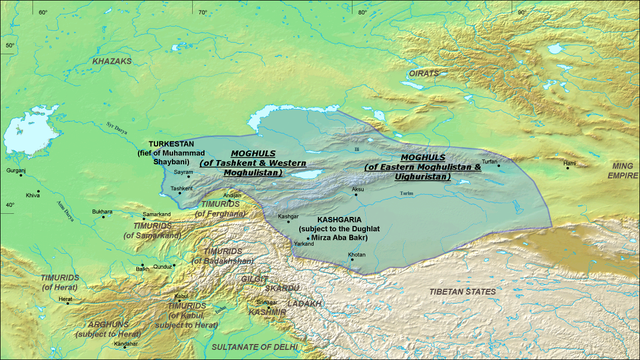
English: A map of the Moghul Chagatai Khanate in 1490 CE. Note: This map is compressed in vertical direction. Please, expand it about 1.3 times to see it undistorted.
ReferencesInformation for the borders of the Moghul khanate came mostly from these two sources:
|
| நாள் | 22 சூலை 2008 (original upload date) |
| மூலம் | Transferred from en.wikipedia to Commons by Betta27. |
| ஆசிரியர் | Ro4444 at ஆங்கிலம் விக்கிப்பீடியா |
அனுமதி
இந்த ஆக்கத்தின் காப்புரிமையாளரான Ro4444 at the English Wikipedia எனும் நான் இதனைப் பின்வரும் உரிமத்தின் கீழ் வெளியிடுகின்றேன்:

|
GNU Free Documentation License விதிமுறைகளின் கீழ் இந்த ஆவணத்தை நகலெடுக்க, விநியோகிக்க மற்றும்/அல்லது மாற்றுவதற்கு அனுமதி வழங்கப்பட்டுள்ளது, Free Software Foundation;ஆல் வெளியிடப்பட்ட பதிப்பு 1.2 அல்லது அதற்குப் பிந்தைய பதிப்பு, மாற்றமில்லாத பிரிவுகள், முன் அட்டை உரைகள் மற்றும் பின் அட்டை உரைகள் இல்லாமல் வெளியிடப்பட்டது. GNU Free Documentation License என்ற தலைப்பில் உரிமத்தின் நகல் சேர்க்கப்பட்டுள்ளது. |
| இந்த கோப்பு Creative Commons Attribution-Share Alike 3.0 Unported உரிமத்தின் கீழ் உள்ளது. | ||
| பண்புக்கூறுகள்: Ro4444 at the English Wikipedia | ||
| ||
| This licensing tag was added to this file as part of the GFDL licensing update. |
Original upload log
The original description page was here. All following user names refer to en.wikipedia.
- 2008-07-22 06:20 Ro4444 1202×677× (811049 bytes) {{Information |Description={{en|1=A map of the Moghul (Chagatai) Khanate in 1490}} |Source=Own work by uploader |Author=ro4444 |Date=22 July 2008 |Permission= |other_versions= }} {{ImageUpload|full}} ==References== Information for the borders of the Mog
]]
கோப்பின் வரலாறு
குறித்த நேரத்தில் இருந்த படிமத்தைப் பார்க்க அந்நேரத்தின் மீது சொடுக்கவும்.
| நாள்/நேரம் | நகம் அளவு சிறுபடம் | அளவுகள் | பயனர் | கருத்து | |
|---|---|---|---|---|---|
| தற்போதைய | 07:16, 30 அக்டோபர் 2010 | | 1,202 × 677 (792 KB) | Betta27 | {{Information |Description={{en|''no original description''}} |Source=Transferred from [http://en.wikipedia.org en.wikipedia]; transfer was stated to be made by User:Betta27. |Date={{Date|2008|07|22}} (original upload date) |Author=. Original uploader |
கோப்பு பயன்பாடு
பின்வரும் 2 பக்கங்கள் இணைப்பு இப் படிமத்துக்கு இணைக்கபட்டுள்ளது(ளன):
கோப்பின் முழுமையான பயன்பாடு
கீழ்கண்ட மற்ற விக்கிகள் இந்த கோப்பை பயன்படுத்துகின்றன:
- azb.wikipedia.org-திட்டத்தில் இதன் பயன்பாடு
- de.wikipedia.org-திட்டத்தில் இதன் பயன்பாடு
- en.wikipedia.org-திட்டத்தில் இதன் பயன்பாடு
- es.wikipedia.org-திட்டத்தில் இதன் பயன்பாடு
- fa.wikipedia.org-திட்டத்தில் இதன் பயன்பாடு
- fr.wikipedia.org-திட்டத்தில் இதன் பயன்பாடு
- it.wikipedia.org-திட்டத்தில் இதன் பயன்பாடு
- ja.wikipedia.org-திட்டத்தில் இதன் பயன்பாடு
- ko.wikipedia.org-திட்டத்தில் இதன் பயன்பாடு
- lt.wikipedia.org-திட்டத்தில் இதன் பயன்பாடு
- mni.wikipedia.org-திட்டத்தில் இதன் பயன்பாடு
- mn.wikipedia.org-திட்டத்தில் இதன் பயன்பாடு
- no.wikipedia.org-திட்டத்தில் இதன் பயன்பாடு
- ru.wikipedia.org-திட்டத்தில் இதன் பயன்பாடு
- sd.wikipedia.org-திட்டத்தில் இதன் பயன்பாடு
- simple.wikipedia.org-திட்டத்தில் இதன் பயன்பாடு
- sl.wikipedia.org-திட்டத்தில் இதன் பயன்பாடு
- tr.wikipedia.org-திட்டத்தில் இதன் பயன்பாடு
- uz.wikipedia.org-திட்டத்தில் இதன் பயன்பாடு
- vi.wikipedia.org-திட்டத்தில் இதன் பயன்பாடு
- zh.wikipedia.org-திட்டத்தில் இதன் பயன்பாடு
.png)