
படிமம்:US Navy 110320-M-0145H-063 A large ferry boat rests inland amidst destroyed houses after a 9.0 earthquake and subsequent tsunami struck Japan March.jpg
இந்த முன்னோட்டத்தின் அளவு: 800 × 533 படப்புள்ளிகள் . மற்ற பிரிதிறன்கள்: 320 × 213 படப்புள்ளிகள் | 640 × 427 படப்புள்ளிகள் | 1,023 × 682 படப்புள்ளிகள் .
மூலக்கோப்பு (1,023 × 682 படவணுக்கள், கோப்பின் அளவு: 221 KB, MIME வகை: image/jpeg)
| இது விக்கிமீடியா பொதுக்கோப்பகத்தில் இருக்கும் ஒரு கோப்பாகும். இக்கோப்பைக் குறித்து அங்கே காணப்படும் படிம விளக்கப் பக்கத்தை இங்கே கீழே காணலாம்.
|
சுருக்கம்
| விளக்கம் |
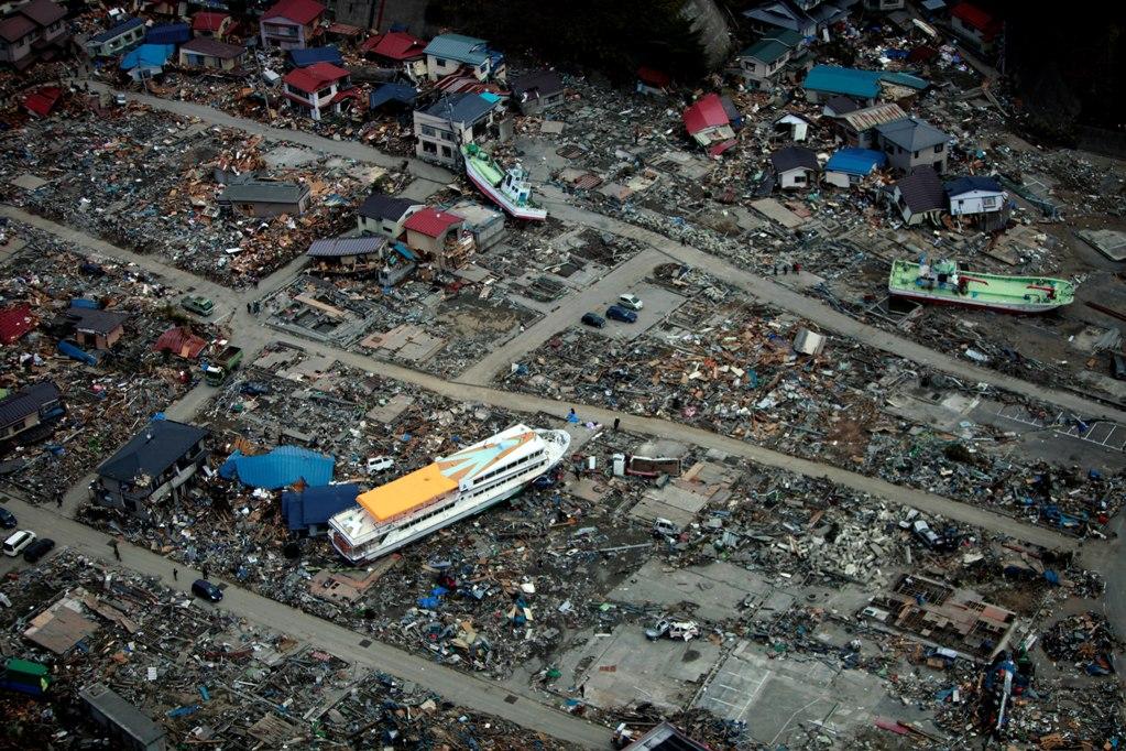
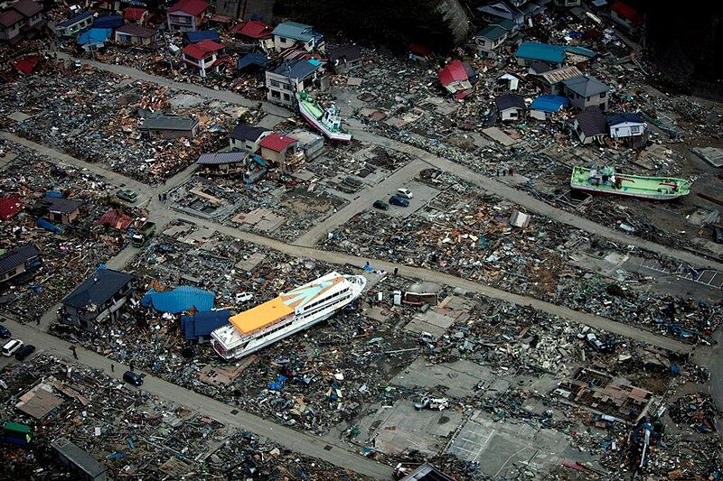
English: Miyako, Iwate Prefecture Japan (March 20, 2011). -- A large ferry boat rests inland amidst destroyed houses after a 9.0 earthquake and subsequent tsunami struck Japan March 11. As part of Operation Tomodachi, the 31st Marine Expeditionary Unit delivered much-needed relief supplies to the Japanese citizens in the area. (U.S. Marine Corps photo by Lance Cpl. Garry Welch/Released)
|
|||
| நாள் | Taken on 20 மார்ச்சு 2011 | |||
| மூலம் |
|
|||
| ஆசிரியர் | U.S. Marine Corps photo by Lance Cpl. Garry Welch |

| Camera location | | View this and other nearby images on: OpenStreetMap |
|---|
அனுமதி
This file is a work of a sailor or employee of the U.S. Navy, taken or made as part of that person's official duties. As a work of the U.S. federal government, it is in the public domain in the United States.
|
 | |
| This file has been identified as being free of known restrictions under copyright law, including all related and neighboring rights. | ||
கோப்பின் வரலாறு
குறித்த நேரத்தில் இருந்த படிமத்தைப் பார்க்க அந்நேரத்தின் மீது சொடுக்கவும்.
| நாள்/நேரம் | நகம் அளவு சிறுபடம் | அளவுகள் | பயனர் | கருத்து | |
|---|---|---|---|---|---|
| தற்போதைய | 02:08, 30 மார்ச்சு 2011 | | 1,023 × 682 (221 KB) | BotMultichillT | == {{int:filedesc}} == {{Information |description={{en|1=AICHI, Japan (March 20, 2011) A large ferry boat rests inland amidst destroyed houses after a 9.0 earthquake and subsequent tsunami struck Japan March 11. As part of Operation Tomodachi, the 31st Ma |
கோப்பு பயன்பாடு
பின்வரும் பக்க இணைப்புகள் இப் படிமத்துக்கு இணைக்கபட்டுள்ளது(ளன):
கோப்பின் முழுமையான பயன்பாடு
கீழ்கண்ட மற்ற விக்கிகள் இந்த கோப்பை பயன்படுத்துகின்றன:
- de.wikipedia.org-திட்டத்தில் இதன் பயன்பாடு
- en.wikipedia.org-திட்டத்தில் இதன் பயன்பாடு
- en.wikivoyage.org-திட்டத்தில் இதன் பயன்பாடு
- ja.wikipedia.org-திட்டத்தில் இதன் பயன்பாடு
- ja.wikinews.org-திட்டத்தில் இதன் பயன்பாடு
- ko.wikipedia.org-திட்டத்தில் இதன் பயன்பாடு
- ms.wikipedia.org-திட்டத்தில் இதன் பயன்பாடு
- pt.wikipedia.org-திட்டத்தில் இதன் பயன்பாடு
- sl.wikipedia.org-திட்டத்தில் இதன் பயன்பாடு
- sr.wikipedia.org-திட்டத்தில் இதன் பயன்பாடு
- sv.wikipedia.org-திட்டத்தில் இதன் பயன்பாடு