
படிமம்:OttomanEmpire1600.png
இந்த முன்னோட்டத்தின் அளவு: 800 × 484 படப்புள்ளிகள் . மற்ற பிரிதிறன்கள்: 320 × 194 படப்புள்ளிகள் | 640 × 387 படப்புள்ளிகள் | 1,024 × 620 படப்புள்ளிகள் | 1,357 × 821 படப்புள்ளிகள் .
மூலக்கோப்பு (1,357 × 821 படவணுக்கள், கோப்பின் அளவு: 44 KB, MIME வகை: image/png)
| இது விக்கிமீடியா பொதுக்கோப்பகத்தில் இருக்கும் ஒரு கோப்பாகும். இக்கோப்பைக் குறித்து அங்கே காணப்படும் படிம விளக்கப் பக்கத்தை இங்கே கீழே காணலாம்.
|

|
This locator map image could be re-created using vector graphics as an SVG file. This has several advantages; see Commons:Media for cleanup for more information. If an SVG form of this image is available, please upload it and afterwards replace this template with
{{vector version available|new image name}}.
It is recommended to name the SVG file “OttomanEmpire1600.svg”—then the template Vector version available (or Vva) does not need the new image name parameter. |
சுருக்கம்
| விளக்கம் |
العربية: خريطة الإمبراطورية العثمانية 1600 (القرن السابع عشر). (يعتمد جزئيًا على أطلس تاريخ العالم (2007) )
الأخضرالغامق : الإمبراطورية العثمانية. الإطار الفاتح: مناطق تابعة ،
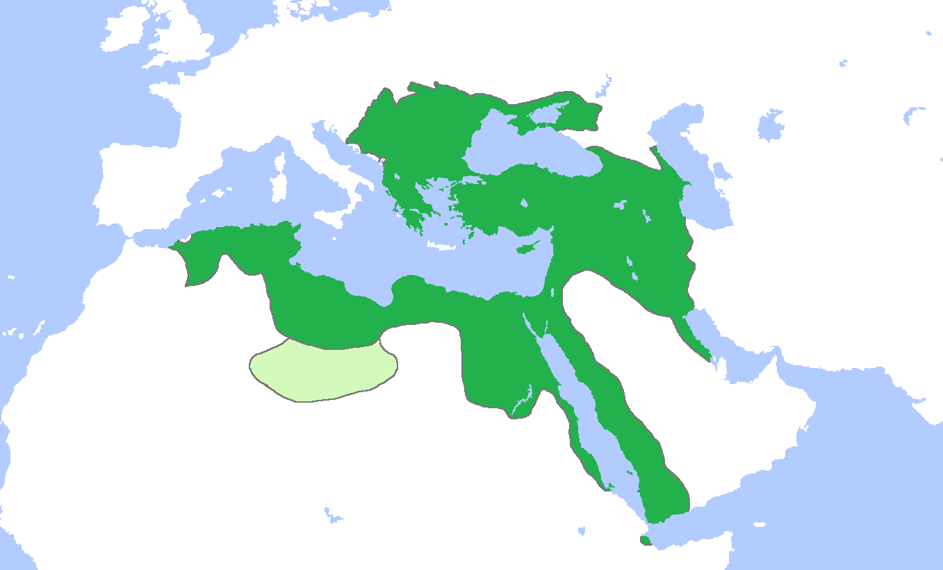
English: Locator map of the Ottoman Empire, c. 1600 (17th century).
(Partially based on Atlas of World History (2007) - The World 1500-1600, map) Green: Ottoman Empire. Light Green: Ottoman vassal, Fezzan. |
| நாள் | |
| மூலம் | சொந்த முயற்சி |
| ஆசிரியர் | Gabagool |
அனுமதி
இந்த ஆக்கத்தின் காப்புரிமையாளரான நான் இதனைப் பின்வரும் உரிமத்தின் கீழ் வெளியிடுகின்றேன்:
This file is licensed under the Creative Commons Attribution 3.0 Unported license.
- நீங்கள் சுதந்திரமாக:
- பகிர்ந்து கொள்ள – வேலையை நகலெடுக்க, விநியோகிக்க மற்றும் அனுப்ப
- மீண்டும் கலக்க – வேலைக்கு பழகிக்கொள்ள.
- கீழ்க்காணும் விதிகளுக்கு ஏற்ப,
- பண்புக்கூறுகள் – நீங்கள் பொருத்தமான உரிமையை வழங்க வேண்டும், உரிமத்திற்கான இணைப்பை வழங்க வேண்டும் மற்றும் மாற்றங்கள் செய்யப்பட்டிருந்தால் குறிப்பிட வேண்டும். நீங்கள் ஏற்புடைய எந்த முறையிலும் அவ்வாறு செய்யலாம், ஆனால் எந்த வகையிலும் உரிமதாரர் உங்களை அல்லது உங்கள் பயன்பாட்டிற்கு ஒப்புதல் அளிக்கும் படி பரிந்துரைக்க கூடாது.
கோப்பின் வரலாறு
குறித்த நேரத்தில் இருந்த படிமத்தைப் பார்க்க அந்நேரத்தின் மீது சொடுக்கவும்.
| நாள்/நேரம் | நகம் அளவு சிறுபடம் | அளவுகள் | பயனர் | கருத்து | |
|---|---|---|---|---|---|
| தற்போதைய | 04:32, 12 சூலை 2023 | | 1,357 × 821 (44 KB) | عبد العزيز علي | Reverted to version as of 20:01, 5 November 2009 (UTC) |
| 20:13, 25 சனவரி 2010 |  | 800 × 484 (90 KB) | Persia2099 | minor change | |
| 20:11, 25 சனவரி 2010 |  | 800 × 484 (90 KB) | Persia2099 | minor change | |
| 20:01, 5 நவம்பர் 2009 |  | 1,357 × 821 (44 KB) | Gabagool | slight crop | |
| 16:46, 5 நவம்பர் 2009 |  | 1,481 × 902 (53 KB) | Gabagool | {{Information |Description={{en|1=Locator map of the Ottoman Empire, c. 1600. (Partially based on ''Atlas of World History'' (2007) - The World 1500-1600, map)}} |Source={{own}} |Author=Gabagool / Jarle Grøhn |Date=2009-11-05 |Permiss |
கோப்பு பயன்பாடு
பின்வரும் 7 பக்கங்கள் இணைப்பு இப் படிமத்துக்கு இணைக்கபட்டுள்ளது(ளன):
கோப்பின் முழுமையான பயன்பாடு
கீழ்கண்ட மற்ற விக்கிகள் இந்த கோப்பை பயன்படுத்துகின்றன:
- ar.wikipedia.org-திட்டத்தில் இதன் பயன்பாடு
- bg.wikipedia.org-திட்டத்தில் இதன் பயன்பாடு
- en.wikipedia.org-திட்டத்தில் இதன் பயன்பாடு
- es.wikipedia.org-திட்டத்தில் இதன் பயன்பாடு
- fa.wikipedia.org-திட்டத்தில் இதன் பயன்பாடு
- fr.wikipedia.org-திட்டத்தில் இதன் பயன்பாடு
- hu.wikipedia.org-திட்டத்தில் இதன் பயன்பாடு
- it.wikipedia.org-திட்டத்தில் இதன் பயன்பாடு
- ru.wikipedia.org-திட்டத்தில் இதன் பயன்பாடு
- uk.wikipedia.org-திட்டத்தில் இதன் பயன்பாடு
- vi.wikipedia.org-திட்டத்தில் இதன் பயன்பாடு