
படிமம்:Map of war in Yugoslavia, 1993.png

இந்த முன்னோட்டத்தின் அளவு: 800 × 527 படப்புள்ளிகள் . மற்ற பிரிதிறன்கள்: 320 × 211 படப்புள்ளிகள் | 640 × 421 படப்புள்ளிகள் | 1,024 × 674 படப்புள்ளிகள் | 1,280 × 842 படப்புள்ளிகள் | 1,887 × 1,242 படப்புள்ளிகள் .
மூலக்கோப்பு (1,887 × 1,242 படவணுக்கள், கோப்பின் அளவு: 195 KB, MIME வகை: image/png)
| இது விக்கிமீடியா பொதுக்கோப்பகத்தில் இருக்கும் ஒரு கோப்பாகும். இக்கோப்பைக் குறித்து அங்கே காணப்படும் படிம விளக்கப் பக்கத்தை இங்கே கீழே காணலாம்.
|

|
This military map image could be re-created using vector graphics as an SVG file. This has several advantages; see Commons:Media for cleanup for more information. If an SVG form of this image is available, please upload it and afterwards replace this template with
{{vector version available|new image name}}.
It is recommended to name the SVG file “Map of war in Yugoslavia, 1993.svg”—then the template Vector version available (or Vva) does not need the new image name parameter. |
சுருக்கம்
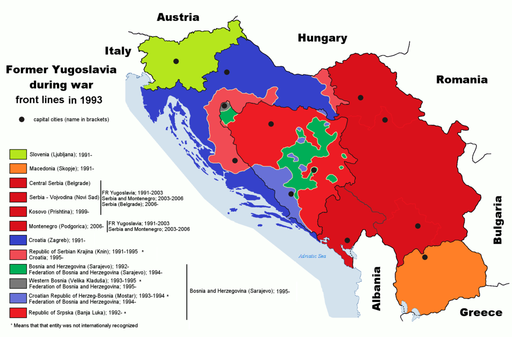
| விளக்கம் | Map of former Yugoslavia during last wars. War political entities in Croatia and Bosnia-Herzegovia are marked |
| நாள் | 6 செப்டெம்பர் 2006 (original upload date) |
| மூலம் | English Wikipedia |
| ஆசிரியர் | Paweł Goleniowski |
| ஒத்தக்கோப்பு |
|


அனுமதி
இந்த ஆக்கத்தின் காப்புரிமையாளரான English Wikipedia user swPawel எனும் நான் இதனைப் பின்வரும் உரிமத்தின் கீழ் வெளியிடுகின்றேன்:

|
GNU Free Documentation License விதிமுறைகளின் கீழ் இந்த ஆவணத்தை நகலெடுக்க, விநியோகிக்க மற்றும்/அல்லது மாற்றுவதற்கு அனுமதி வழங்கப்பட்டுள்ளது, Free Software Foundation;ஆல் வெளியிடப்பட்ட பதிப்பு 1.2 அல்லது அதற்குப் பிந்தைய பதிப்பு, மாற்றமில்லாத பிரிவுகள், முன் அட்டை உரைகள் மற்றும் பின் அட்டை உரைகள் இல்லாமல் வெளியிடப்பட்டது. GNU Free Documentation License என்ற தலைப்பில் உரிமத்தின் நகல் சேர்க்கப்பட்டுள்ளது. |
| இந்த கோப்பு Creative Commons Attribution-Share Alike 3.0 Unported உரிமத்தின் கீழ் உள்ளது. | ||
| பண்புக்கூறுகள்: English Wikipedia user swPawel | ||
| ||
| This licensing tag was added to this file as part of the GFDL licensing update. |
Original upload log
The original description page was here. All following user names refer to en.wikipedia.
- 2011-07-21 10:50 DIREKTOR 1887×1242× (101751 bytes) Colors
- 2011-07-21 01:14 DIREKTOR 1887×1242× (101751 bytes) Further
- 2011-07-21 01:05 DIREKTOR 1887×1242× (95186 bytes) rm IEBL
- 2011-07-20 21:29 DIREKTOR 1887×1242× (96335 bytes) Fixed hues
- 2011-07-20 19:33 DIREKTOR 1887×1242× (96341 bytes) Colors
- 2008-08-10 11:19 Ceha 1887×1242× (97449 bytes) Changed front lines around Bihać. See http://en.wikipedia.org/wiki/Image:Western_Bosnia_1994.png
- 2006-09-06 00:05 Ceha 1887×1242× (97506 bytes)
கோப்பின் வரலாறு
குறித்த நேரத்தில் இருந்த படிமத்தைப் பார்க்க அந்நேரத்தின் மீது சொடுக்கவும்.
| நாள்/நேரம் | நகம் அளவு சிறுபடம் | அளவுகள் | பயனர் | கருத்து | |
|---|---|---|---|---|---|
| தற்போதைய | 18:07, 26 ஏப்பிரல் 2023 | | 1,887 × 1,242 (195 KB) | Drax90 | little fix: updated map |
| 12:54, 26 ஏப்பிரல் 2023 |  | 1,887 × 1,242 (195 KB) | Drax90 | New color version; updated map | |
| 08:31, 11 சனவரி 2016 |  | 1,887 × 1,242 (196 KB) | Drax90 | latest version of the 1993 map | |
| 08:53, 4 சனவரி 2016 |  | 1,887 × 1,242 (146 KB) | Drax90 | Added new version of border colors for the internationally recognized Yugoslav republics | |
| 08:47, 4 சனவரி 2016 |  | 1,887 × 1,242 (196 KB) | Drax90 | New version of this map, with improved colors | |
| 18:36, 15 ஏப்பிரல் 2012 |  | 1,887 × 1,242 (86 KB) | Spesh531 | updated colors and made all capital city circles the same, added for montenegro, vojvodina, and kosova. | |
| 11:41, 19 திசம்பர் 2011 |  | 1,887 × 1,242 (100 KB) | DIREKTOR | Colours | |
| 19:56, 18 திசம்பர் 2011 |  | 1,887 × 1,242 (100 KB) | DIREKTOR | Minor fixes | |
| 12:39, 12 நவம்பர் 2011 |  | 1,887 × 1,242 (99 KB) | OgreBot | (BOT): Uploading old version of file from en.wikipedia; originally uploaded on 2011-07-21 01:14:33 by DIREKTOR | |
| 12:39, 12 நவம்பர் 2011 |  | 1,887 × 1,242 (93 KB) | OgreBot | (BOT): Uploading old version of file from en.wikipedia; originally uploaded on 2011-07-21 01:05:54 by DIREKTOR |
கோப்பு பயன்பாடு
பின்வரும் பக்க இணைப்புகள் இப் படிமத்துக்கு இணைக்கபட்டுள்ளது(ளன):
கோப்பின் முழுமையான பயன்பாடு
கீழ்கண்ட மற்ற விக்கிகள் இந்த கோப்பை பயன்படுத்துகின்றன:
- ar.wikipedia.org-திட்டத்தில் இதன் பயன்பாடு
- ast.wikipedia.org-திட்டத்தில் இதன் பயன்பாடு
- azb.wikipedia.org-திட்டத்தில் இதன் பயன்பாடு
- ca.wikipedia.org-திட்டத்தில் இதன் பயன்பாடு
- en.wikipedia.org-திட்டத்தில் இதன் பயன்பாடு
- es.wikipedia.org-திட்டத்தில் இதன் பயன்பாடு
- fr.wikipedia.org-திட்டத்தில் இதன் பயன்பாடு
- id.wikipedia.org-திட்டத்தில் இதன் பயன்பாடு
- ro.wikipedia.org-திட்டத்தில் இதன் பயன்பாடு
- uk.wikipedia.org-திட்டத்தில் இதன் பயன்பாடு