
படிமம்:Klimagürtel-der-erde.png

இந்த முன்னோட்டத்தின் அளவு: 800 × 400 படப்புள்ளிகள் . மற்ற பிரிதிறன்கள்: 320 × 160 படப்புள்ளிகள் | 640 × 320 படப்புள்ளிகள் | 1,024 × 512 படப்புள்ளிகள் | 1,280 × 640 படப்புள்ளிகள் | 3,600 × 1,800 படப்புள்ளிகள் .
மூலக்கோப்பு (3,600 × 1,800 படவணுக்கள், கோப்பின் அளவு: 591 KB, MIME வகை: image/png)
| இது விக்கிமீடியா பொதுக்கோப்பகத்தில் இருக்கும் ஒரு கோப்பாகும். இக்கோப்பைக் குறித்து அங்கே காணப்படும் படிம விளக்கப் பக்கத்தை இங்கே கீழே காணலாம்.
|
சுருக்கம்
| விளக்கம் |
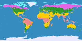
English: This map shows the Earth zones with tropical climate.
Ice cap climate Tundra climate Boreal climate Warm temperate climate Subtropical climate Tropical climate
Deutsch: Diese Karte stellt die Klimagürtel der Erde dar.
Eisklima Tundrenklima Boreales Klima Warmgemäßigtes Klima Subtropisches Klima Tropisches Klima
Ελληνικά: Αυτός ο χάρτης δείχνει τις ζώνες της γης με τροπικό κλίμα.
Πολικό κλίμα Κλίμα τούνδρας Αρκτικό κλίμα Εύκρατο κλίμα Υποτροπικό κλίμα Τροπικό κλίμα
Português: Este mapa mostra as áreas do planeta Terra com clima tropical.
Clima Polar Clima de Tundra Clima Boreal Clima Temperado Clima Subtropical Clima Tropical
Español: Este mapa muestra las zonas de la Tierra con clima tropical.
Clima Polar Clima de Tundra Clima Boreal Clima Templado Clima Subtropical Clima Tropical |
| நாள் | |
| மூலம் |
English: Own work on the basis of the following data: Deutsch: Selbst erstellt auf Basis dieser Geodaten:
|
| ஆசிரியர் | |
| ஒத்தக்கோப்பு |
|

அனுமதி
இந்த கோப்பு Creative Commons Attribution-Share Alike 3.0 Unported உரிமத்தின் கீழ் உள்ளது.
- நீங்கள் சுதந்திரமாக:
- பகிர்ந்து கொள்ள – வேலையை நகலெடுக்க, விநியோகிக்க மற்றும் அனுப்ப
- மீண்டும் கலக்க – வேலைக்கு பழகிக்கொள்ள.
- கீழ்க்காணும் விதிகளுக்கு ஏற்ப,
- பண்புக்கூறுகள் – நீங்கள் பொருத்தமான உரிமையை வழங்க வேண்டும், உரிமத்திற்கான இணைப்பை வழங்க வேண்டும் மற்றும் மாற்றங்கள் செய்யப்பட்டிருந்தால் குறிப்பிட வேண்டும். நீங்கள் ஏற்புடைய எந்த முறையிலும் அவ்வாறு செய்யலாம், ஆனால் எந்த வகையிலும் உரிமதாரர் உங்களை அல்லது உங்கள் பயன்பாட்டிற்கு ஒப்புதல் அளிக்கும் படி பரிந்துரைக்க கூடாது.
- அதே மாதிரி பகிர் – நீங்கள் ரீமிக்ஸ் செய்தாலோ, உருமாற்றம் செய்தாலோ அல்லது பொருளை உருவாக்கினாலோ, உங்கள் பங்களிப்புகளை அல்லது இணக்கமான உரிமம் கீழ் அசலாக விநியோகிக்க வேண்டும்.
கோப்பின் வரலாறு
குறித்த நேரத்தில் இருந்த படிமத்தைப் பார்க்க அந்நேரத்தின் மீது சொடுக்கவும்.
| நாள்/நேரம் | நகம் அளவு சிறுபடம் | அளவுகள் | பயனர் | கருத்து | |
|---|---|---|---|---|---|
| தற்போதைய | 19:08, 24 சூன் 2017 | | 3,600 × 1,800 (591 KB) | Alatab | Costa Rican Central Valley has a Cwb clasification (Oceanic climate). |
| 21:01, 11 அக்டோபர் 2016 |  | 3,600 × 1,800 (765 KB) | Maphobbyist | The Caspian Sea was omitted. The Köppen system is based on the concept that climate types are correlated with the natural vegetation. | |
| 14:50, 15 அக்டோபர் 2007 |  | 3,600 × 1,800 (662 KB) | Lortordermur | == Beschreibung == {{Information |Description=Diese Karte stellt die Klimagürtel der Erde dar. {{legend|#eaeaff|Eisklima}} {{legend|#19ebed|Tundrenklima}} {{legend|#e465e6|Boreales Klima}} {{legend|#2a982a|Warmgemäßigtes Klima}} {{legend|#ffcc00|Su | |
| 20:27, 23 மே 2007 |  | 3,445 × 1,731 (704 KB) | Lortordermur | {{Information |Description=Diese Karte stellt die Klimagürtel der Erde dar. {{legend|#eaeaff|Eisklima}} {{legend|#19ebed|Tundrenklima}} {{legend|#e465e6|Boreales Klima}} {{legend|#2a982a|Warmgemäßigtes Klima}} {{legend|#ffcc00|Subtropisches Klima}} |
கோப்பு பயன்பாடு
பின்வரும் 2 பக்கங்கள் இணைப்பு இப் படிமத்துக்கு இணைக்கபட்டுள்ளது(ளன):
கோப்பின் முழுமையான பயன்பாடு
கீழ்கண்ட மற்ற விக்கிகள் இந்த கோப்பை பயன்படுத்துகின்றன:
- ang.wikipedia.org-திட்டத்தில் இதன் பயன்பாடு
- ast.wikipedia.org-திட்டத்தில் இதன் பயன்பாடு
- be.wikipedia.org-திட்டத்தில் இதன் பயன்பாடு
- bg.wikipedia.org-திட்டத்தில் இதன் பயன்பாடு
- bn.wikipedia.org-திட்டத்தில் இதன் பயன்பாடு
- bs.wikipedia.org-திட்டத்தில் இதன் பயன்பாடு
- ca.wikipedia.org-திட்டத்தில் இதன் பயன்பாடு
- ce.wikipedia.org-திட்டத்தில் இதன் பயன்பாடு
- el.wikipedia.org-திட்டத்தில் இதன் பயன்பாடு
- en.wikipedia.org-திட்டத்தில் இதன் பயன்பாடு
- eo.wikipedia.org-திட்டத்தில் இதன் பயன்பாடு
- et.wikipedia.org-திட்டத்தில் இதன் பயன்பாடு
- eu.wikipedia.org-திட்டத்தில் இதன் பயன்பாடு
- fa.wikipedia.org-திட்டத்தில் இதன் பயன்பாடு
- fi.wikipedia.org-திட்டத்தில் இதன் பயன்பாடு
- fr.wikipedia.org-திட்டத்தில் இதன் பயன்பாடு
- gl.wikipedia.org-திட்டத்தில் இதன் பயன்பாடு
- he.wiktionary.org-திட்டத்தில் இதன் பயன்பாடு
- hi.wikipedia.org-திட்டத்தில் இதன் பயன்பாடு
- hy.wikipedia.org-திட்டத்தில் இதன் பயன்பாடு
- id.wikipedia.org-திட்டத்தில் இதன் பயன்பாடு
- is.wikipedia.org-திட்டத்தில் இதன் பயன்பாடு
- it.wikipedia.org-திட்டத்தில் இதன் பயன்பாடு
- it.wikibooks.org-திட்டத்தில் இதன் பயன்பாடு
- it.wikiversity.org-திட்டத்தில் இதன் பயன்பாடு
- kk.wikipedia.org-திட்டத்தில் இதன் பயன்பாடு
- la.wikipedia.org-திட்டத்தில் இதன் பயன்பாடு
- mk.wikipedia.org-திட்டத்தில் இதன் பயன்பாடு
- my.wikipedia.org-திட்டத்தில் இதன் பயன்பாடு
- nn.wikipedia.org-திட்டத்தில் இதன் பயன்பாடு
- no.wikipedia.org-திட்டத்தில் இதன் பயன்பாடு
- ro.wikipedia.org-திட்டத்தில் இதன் பயன்பாடு
- ru.wikipedia.org-திட்டத்தில் இதன் பயன்பாடு
- simple.wikipedia.org-திட்டத்தில் இதன் பயன்பாடு
- si.wikipedia.org-திட்டத்தில் இதன் பயன்பாடு
- sv.wikipedia.org-திட்டத்தில் இதன் பயன்பாடு
- uk.wikipedia.org-திட்டத்தில் இதன் பயன்பாடு
- vi.wikipedia.org-திட்டத்தில் இதன் பயன்பாடு
- zh-min-nan.wikipedia.org-திட்டத்தில் இதன் பயன்பாடு